MATTHEWS c1856 Map Of Upper Canada Ontario Indian Land Agency Divisions Scarce!Luis Porretta Fine Arts4.3(10)See Sold PriceMar 02, 2024
DEVINE c1856 Dr Salters Map Of Lake Huron Ontario Indian Lands etc. No. 7 ScarceLuis Porretta Fine Arts4.3(10)See Sold PriceMar 02, 2024
DUNLEVIE c1856 Map Counties Of Gaspe & Bonaventure Quebec Canada SCARCE! #1Luis Porretta Fine Arts4.3(10)See Sold PriceMar 02, 2024
DUNLEVIE c1856 Map Counties Of Gaspe & Bonaventure Quebec Canada SCARCE! #2Luis Porretta Fine Arts4.3(10)See Sold PriceMar 02, 2024
Map UNITED COUNTIES LEEDS & GRENVILLE by Walling 1861 Rare Canada Map 5ft x 5ftLuis Porretta Fine Arts4.3(10)See Sold PriceMar 02, 2024
Ambroise TARDIEU c1822 Map Venice Napoleon Italian Campaign 17" x 11"Luis Porretta Fine Arts4.3(10)See Sold PriceMar 02, 2024
Bartholomew: Map of Lower Provinces (Canada), 1898Map: Lower Provinces (Canada), Manitoba & Western Provinces Date: 1898 Size: 18 x 14 inches From Bartholomew's "The Citizen's Atlas of the World". With Inset of St. John and Halifax. Please note thatSee Sold Price
Bartholomew: Map of the Dominion of Canada, 1898Map: Dominion of Canada Date: 1898 From Bartholomew's "The Citizen's Atlas of the World" Size: 18 x 14 inches Please note that this lot has a confidential reserve. When you leave a bid in advance of tSee Sold Price
SoldPair of Early 19th Century Maps of CanadaPair of maps titled "A Map of the Province of Upper Canada" (1838) and "A Map of the Province of Lower Canada" (1840) by James Wyld, London. Maps measure 23.5" x 37" and exhibit hand-colored highlightSee Sold Price
MAP, Eastern Canada & Maine, WyldEastern Canada & Maine. James Wyld, A New Map of the Province of Lower Canada, Describing All the Seigneuries, Townships, Grants of Land, &c. Compiled from Plans Deposited in the Patent Office Quebec;See Sold Price
SoldWYLD, JAMES. A New Map of the Province of LoweWYLD, JAMES. A New Map of the Province of Lower Canada. Two-sheet engraved map, 580x885 mm, top and bottom margin close, others wide; hand-colored in outline; a few cellotape repairs on verso with resSee Sold Price
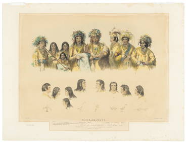
[MAP]. BOUCHETTE. Lower & Upper Canada.... 1831243. [MAP]. BOUCHETTE, Joseph, Jun. [Joseph Bouchette, Sr. & James Wyld]. To His Most Excellent Majesty King William IVth. This Map of the Provinces of Lower & Upper Canada, Nova Scotia, New BSee Sold Price
SoldJOHNSON'S MAP OF UPPER AND LOWER CANADACirca 1863, tinted, measures 26 x 18 inches overall, shows mild wear and toning.See Sold Price
SoldBouchette (Joseph) A Topographical Description ofBouchette (Joseph) A Topographical Description of the Province of Lower Canada...,engraved portrait frontispiece, 8 maps or plans (some folding) and 2 tables (1 folding), 7 aquatint plates, soSee Sold Price
SoldAmericas.- North America.- Bouchette (Joseph) AAmericas.- North America.- Bouchette (Joseph) A Topographical Description of the Province of Lower Canada, with Remarks upon Upper Canada, first edition, engraved portrait, 8 maps and plans (4 foldingSee Sold Price
SoldCanada.- Bouchette (Joseph) A Topographical DescriptionCanada.- Bouchette (Joseph) A Topographical Description of the Province of Lower Canada, with remarks upon Upper Canada, first edition, engraved portrait frontispiece, 7 aquatint plates, 8 engraved maSee Sold Price
Canada.- Bouchette (Joseph) A Topographical DescriptionCanada.- Bouchette (Joseph) A Topographical Description of the Province of Lower Canada, with remarks upon Upper Canada, first edition, engraved portrait frontispiece, 7 aquatint plates, 8 engraved maSee Sold Price
SoldBouchette. Lower CanadaBouchette (Joseph) A Topographical Description of the Province of Lower Canada, with Remarks upon Upper Canada,first edition, portrait, 8 partly coloured maps and plans, 4 folding, 7 plates, 2See Sold Price
SoldCanada.- Bouchette (Joseph)Canada.- Bouchette (Joseph) The British Dominions in North America [&] A Topographical Dictionary of the Province of Lower Canada, together 3 vol., engraved and lithographed plates and maps (sSee Sold Price
SoldCanada.- Bouchette (Joseph)Canada.- Bouchette (Joseph) The British Dominions in North America [&] A Topographical Dictionary of the Province of Lower Canada, together 3 vol., engraved and lithographed plates and maps (sSee Sold Price
Sold(TRAVEL.) Weld, Isaac. Travels through the States of(TRAVEL.) Weld, Isaac. Travels through the States of North America, and the Provinces of Upper and Lower Canada. 5 folding maps and plans (one hand-colored in outline), 11 folding plates. xix, [1], 42See Sold Price
SoldLarge folding map of the U.S. & Canada 1827Title: Map of the United States; and the Provinces of Upper & Lower Canada, New Brunswick, and Nova Scotia, compiled from the latest Surveys and other authentic information Author: Walker, John & AlexSee Sold Price
SoldWalker map of U.S. & Canada 1827Heading: Author: Walker, John & Alexander Title: Map of the United States; and the Provinces of Upper & Lower Canada, New Brunswick, and Nova Scotia. Compiled from the Latest Surveys and other authenSee Sold Price
SoldLarge Wyld map of U.S. 1839Heading: Author: Wyld, James Title: Map of the United States; and the Provinces of Upper & Lower Canada, New Brunswick, and Nova Scotia. Compiled from the Latest Surveys and other authentic informatiSee Sold Price
SoldBartholomew: Map of Turkey in Asia Persia Arabia, 1898Map: Turkey in Asia, Persia, Arabia &c. Date: 1898 With inset of Cyprus and Lower Egypt From Bartholomew's "The Citizen Atlas of the World" Size: 14 x 17.75 inches Please note that this lot has a confSee Sold Price
SoldCanada.- Bouchette (Joseph) The British Dominions inCanada.- Bouchette (Joseph) The British Dominions in North America; or a Topographical and Statistical Description of the Provinces of Lower and Upper Canada, 2 vol., 30 engraved, lithographed or aquaSee Sold Price
SoldWalker (John and Alexander) United StatesWalker (John and Alexander) Map of the United States and the Provinces of Upper & Lower Canada, New Brunswick and Nova Scotia, engraved map on 4 sheets, unjoined, with original hand-colouringSee Sold Price
SoldBartholomew, John 1922 Lot of 4 Large Maps of India"North Western Section" "North Eastern Section" "Southern Section" and "Provinces of the Lower Ganges" Large Lithograph Map Published 1922 by The Times, London for "The Times Survey Atlas of the WorldSee Sold Price
Bartholomew, John 1922 Lot of 4 Large Maps of India"North Western Section" "North Eastern Section" "Southern Section" and "Provinces of the Lower Ganges" Large Lithograph Map Published 1922 by The Times, London for "The Times Survey Atlas of the WorldSee Sold Price
SoldBartholomew, John 1922 Lot of 8 Maps of CanadaIncl Political, British Columbia, Alberta/Saskatchewan, Manitoba/North West Ontario, Ontario/Quebec, Maritime Provinces/Newfoundland, Western Canada, and North Eastern Canada. Large Lithograph Maps PuSee Sold Price
1875 Rand Avery and Co. Map of Express Companies and Railroads of the USA and CanadaJM Hobby Supply and Railroad Artifact Auctions4.4(126)See Sold PriceFeb 24, 2024
Crams Township and Railroad Map of Pennsylvania-1898JM Hobby Supply and Railroad Artifact Auctions4.4(126)See Sold PriceFeb 24, 2024
MATTHEWS c1856 Map Of Upper Canada Ontario Indian Land Agency Divisions Scarce!Luis Porretta Fine Arts4.3(10)See Sold PriceMar 02, 2024
17th Century Hand Colored Engraved Map of GermanyGlobal Auctions Company4.3(36)See Sold PriceMar 03, 2024
[MAP]. [ALBRIZZI, Giambatista, 1698-1777]. Carta Geografica...Potter & Potter Auctions4.6(544)See Sold PriceMar 07, 2024
Sweet Caporal Cigarettes WWII-Era PosterMiller & Miller Auctions Ltd.4.7(316)See Sold PriceMar 02, 2024
Trans Canada Airlines "New York to Toronto" Service PosterMiller & Miller Auctions Ltd.4.7(316)See Sold PriceMar 02, 2024
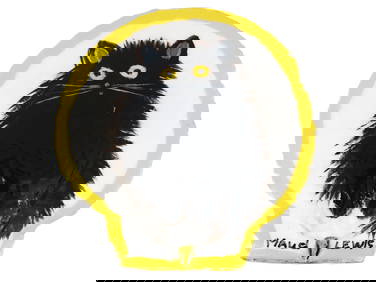
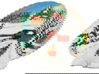
CANADIAN FOLK OIL PAINTING ON SHELL BY MAUD LEWISAntique Arena Inc.4.5(866)See Sold PriceMar 02, 2024
CANADIAN FOLK OIL PAINTING ON SHELL BY MAUD LEWISAntique Arena Inc.4.5(866)See Sold PriceMar 02, 2024
Algeria Morocco & Tunis. North Africa. Tunisia. Maghreb. BARTHOLOMEW 1898 mapJasper524.5(9.8k)See Sold PriceFeb 28, 2024
COLONIAL CENTRAL AFRICA. Congo German East Africa Rhodesia. BARTHOLOMEW 1898 mapJasper524.5(9.8k)See Sold PriceFeb 28, 2024
NORTH AFRICA. Morocco Algeria Tunis Tunisia Egypt. Cairo. BARTHOLOMEW 1912 mapJasper524.5(9.8k)See Sold PriceFeb 28, 2024
NORTH AFRICA. Morocco Algeria Tunis Tunisia Egypt. Cairo. BARTHOLOMEW 1901 mapJasper524.5(9.8k)See Sold PriceFeb 28, 2024
Two Hand-Colored 19th Century Maps of New Orleans and Louisiana, Larger- H.- 12 1/2 in., W.- 15 1/2Crescent City Auction Gallery4.3(231)See Sold PriceMar 08, 2024
Cooke, George 1801 Antique Map. United States of AmericaAlbion Auctions4.6(341)See Sold PriceMar 01, 2024
Robert de Vaugondy - Map of Canada - Mer de l' Ouest or Sea of the West and a Northwest PassageProverde Auctions4.3(3)See Sold PriceFeb 28, 2024
John Senex Map of Louisiana & Mississippi RiverWillow Auction House4.5(284)See Sold PriceMar 14, 2024


![[MAP]. BOUCHETTE. Lower & Upper Canada.... 1831 (1 of 10)](https://p1.liveauctioneers.com/514/38480/16487090_1_x.jpg?height=282&quality=70&version=1363614971)


![[MAP]. [ALBRIZZI, Giambatista, 1698-1777]. Carta Geografica... (1 of 1)](https://p1.liveauctioneers.com/928/318880/171361280_1_x.jpg?height=282&quality=70&version=1707501302)