Claude Monet French 1840 - 1926 Oil on canvas Painting Impressionism Renoir Manet Pissarro Era.International Art Auction Gallery4.5(154)See Sold PriceFeb 24, 2024
Antique American Hudson River School Sunset Landscape Framed Original Oil PaintingCurated Gallery Auctions4.6(120)See Sold PriceFeb 25, 2024
Robert William Wood (1889 - 1979) Texas BluebonnetsPremier Auction Galleries4.3(329)See Sold PriceMar 09, 2024
BIRGER SANDZEN (1871-1954) COLORADO OIL ON CANVAS 1936Soulis Auctions4.8(953)See Sold PriceFeb 24, 2024
George Adomeit (American 1879-1964) CAPE COD LandscapePremier Auction Galleries4.3(329)See Sold PriceMar 09, 2024
Vincent Van Gogh Dutch 1853-1890 Oil on canvas. Paul Gaugin, Cezanne, Degas EraInternational Art Auction Gallery4.5(154)See Sold PriceFeb 24, 2024
Renaissance Old Master Altarpiece Adoration Magi Oil Painting Christ Child Virgin Mary Wise MenHess Fine Auctions4.5(197)See Sold PriceMar 02, 2024
19TH C GERMAN OIL PAINTING BY EMIL ZSCHIMMER C 1872Antique Arena Inc.4.5(852)See Sold PriceFeb 24, 2024
JOHN CONSTABLE ANTIQUE ENGLISH CLOUDS OIL PAINTINGAntique Arena Inc.4.5(852)See Sold PriceFeb 24, 2024
ATTRIBUTED TO GILBERT STUART (MA/RI/UK, 1755-1828)Thomaston Place Auction Galleries4.4(386)See Sold PriceFeb 24, 2024
Pablo Picasso Spanish 1881-1973 Oil On Canvas Painting Dali Magritte Braque Juan GrisInternational Art Auction Gallery4.5(154)See Sold PriceFeb 24, 2024
ATTRIB Francisco Miralles Y Galup (Spain,France,1848-1901) oil painting antiqueBroward Auction Gallery4.8(277)See Sold PriceMar 10, 2024
AMERICAN SCHOOL (Early 20th c) Two WorksJohn McInnis Auctioneers,LLC4.6(502)See Sold PriceFeb 25, 2024
Marc Chagall-Limited Edition -Paris Opera Ceiling after ChagallArt Legacy Auctions4.5(217)See Sold PriceFeb 24, 2024
SoldA Late 17th Century Map of Poland, Prussia, LithuaniaNicolaas Visscher after N. Sanson, c.1690, decorative cartouche showing two wind heads, a cheetah’s head and two sets of bows and arrows reads 'abula nova totius Regni Poloniae in quo sunt DucaSee Sold Price
SoldA 17th Century Map of Poland, lithuania, Ukraine,Johannes de Ram, c.1690, titled 'Regni Poloniae et Ducatus Lithuaniae Volhyniae, Podoliae, Ucraniae, Livoniae et Curlandiae, Descriptio, Ementata de Johannes de Ram', Copperplate engraving original unSee Sold Price
SoldA John Speed, 17th Century Map of Poland,Speed, John (1552-1629). 17th-Century map of Poland, hand-coloured copper engraving, featuring inset city views and figures displaying regional fashions/costumes, published by Bassett & Chiswell, EnglSee Sold Price
SoldA Large Scale 17th Century Map of Poland andSANSON, N and JAILLOT, A.H., Paris 1685, titled 'Les Estates de Couronnede de Pologne en leurs Palatinatsqui comprennet Le Royaume de Pologne, Le Grande Duche de Lithuanie', Large scale map of PolandSee Sold Price
Sold17th Century Map of the Southeast"[Virginiae partis australis, et Floridae partis orientalis…,]" by Willem Blaeu, after Mercator and Hondius, from Blaeu's [Theatre du Monde ou Nouvel Atlas,] Amsterdam, 1640, showing the coastline aSee Sold Price
Sold17th century map "Le Canada ou Nouvelle France", 17" x17th century map "Le Canada ou Nouvelle France", 17" x 23".See Sold Price
SoldAbraham Ortelius 17th Century Map of Turcici ImperiiAbraham Ortelius 17th Century Map of Turcici Imperii Descriptio 17''x22'' Sheet. Hand colored with text on verso. From the edition of ''Theatrum Orbis Terrarum''. Loose, unframed. Overall wear from agSee Sold Price
SoldHenricus Hondius 17th Century Map of Terra Firma etHenricus Hondius 17th Century Map of Terra Firma et Novum Regnum Gratense et Popayan 17.5''x22'' Sheet. Hand colored map of Central American with text on verso. Loose, unframed. Slight overall wear frSee Sold Price
SoldA 17th Century Map of Lithuania, Latvia, Poland,published c. 1662, Willem Janszoon Blaeu (1570–1630), cartouch reads 'Magni Ducatus Lithuaniae et Regionum Adiacentium exacta Descriptio . . . D.Nicolai Christopheri Radziwil . . .' detailed maSee Sold Price
SoldA 17th Century Map of Zamosc in Poland,Braun & Hogenberg, C.1618, titled 'Zamoscium. Nova Poloniae civitas, à magnifico eius regni Cancellaro à fundamentis exstructa', unusual birds-eye view of the walled city, with cartouchee to topSee Sold Price
SoldRare 17th Century Map: Nova Persiae Armeniae NatoliaeHand colored Cornelis Danckerts edition of this decorative and highly desireable map of the region bounded by the Saudi Peninsula, Red Sea, Nile River, Cyprus, Asia Minor, the Gulf of Aden, Indian OceSee Sold Price
SoldA 17th Century Map of Zamosc in Poland,C.1618, titled ‘Zamoscium. Nova Poloniae civitas, à magnifico eius regni Cancellaro à fundamentis exstructa’, unusual birds-eye view of the walled city, with cartouchee to top leftSee Sold Price
Sold17th Century Map of CarolinaA New Description of Carolina by the order of the Lord's Proprietors, John Ogilby, 1670, engraver James Maxon, double page laid paper with grape cluster watermark, includes hand-colored depictions ofSee Sold Price
Sold17th Century MapComittus Tirolean framed early map, size is 19 x 23 book leaf, double sidedSee Sold Price
SoldA 17th Century Map of Poland,J. Janssonius - Moses Pitt, c.1680, cartouche reads 'Novissima POLONIAE REGNI descriptio, copper engraving hand coloured, verso with latin text, dimensions 60.5cm x 50.5cm. Note: From the English atlaSee Sold Price
SoldSicilia Regnum, Johannes Janssonius, 17th Century MapAmsterdam: ca. date mid/late 17th century. Copper engraved map of Sicily oriented towards the north by Joannis Janssonii from the Atlas Contractus, sive Atlantis Majoris Compendium, . . . AmSee Sold Price
A 17th century map engravingA 17th century map engraving after Abraham Ortelius, 'Africae Tabula Nova', 38 x 50.5 cm, framedSee Sold Price
SoldJohannes Cloppenburg 17th Century Map of theJohannes Cloppenburg 17th Century Map of the Southeastern CoastVirginiae Item et Floridae Americae Provinciarum, nova Descriptio (Amsterdam, 1630 or later), copperplate engraving with color, depicts tSee Sold Price
Sold17th Century Map of the Fife Region of ScotlandFramed map titled "Fifae Pars Orientalis" by Joan Bleau (1596-1673). This hand-colored map of the Fife region of Scotland was published in 1665 and measures 16.5" x 21" (sight) and is housed in a framSee Sold Price
SoldLate 17th Century Map Terr Artiche", c.1691by Vincenzo Maria Coronelli (Venice), depicting the north polar regions, embellished with wind heads, framed, 49cm x 70cmSee Sold Price
Sold17th Century Map of the Southeast[Nova Virginiae Tabula], by Arnoldus Montanus or John Ogilby, Amsterdam/London, 1671 (published the same year in two different atlases), based on the Hondius-Blaeu version of John Smith's 1612 map ofSee Sold Price
Sold17th Century Map of the Southeast[Virginiae partis Australis, et Floridae orientalis, interjacentiumqus regionum Nova Descriptio] by Jan Jansson, after works by Blaeu and Hondium, from Jansson's [Novus Atlas, Sive Theatrum Orbis TerrSee Sold Price
SoldJan Janssonius Mid 17th Century Map of Amsterdam21" x 15 1/2" in a thin wood frame, Jan Janssonius (1588-1664) Dutch cartographer, he produced his first maps 1616 of France and Italy. This hand colored map of Amsterdam is now framed, it was foldedSee Sold Price
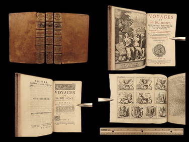
1699 Jean Dumont VOYAGES in France Italy Germany ROME Malta Turkey Ottoman 3vSchilb Antiquarian Rare Books4.8(421)See Sold PriceMar 31, 2024
17th Century Hand Colored Engraved Map of GermanyGlobal Auctions Company4.3(36)See Sold PriceMar 03, 2024
Willem Blaeu, Etc. 17th C. Antiquarian Maps, 2Auctions at Showplace4.5(726)See Sold PriceMar 17, 2024
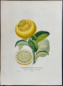
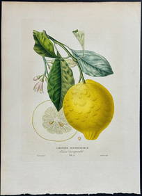
Risso - Lemon or Citrus Fruit. 73Trillium Antique Prints & Rare Books4.5(30)See Sold PriceFeb 24, 2024
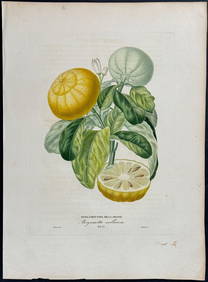
Risso - Lemon or Citrus Fruit. 71Trillium Antique Prints & Rare Books4.5(30)See Sold PriceFeb 24, 2024
WEST AFRICA Niger/Gambia rivers tribes towns. 'Pays des Negres'. MALLET 1683 mapJasper524.5(9.8k)See Sold PriceFeb 28, 2024
WEST AFRICA. Guinea. Nigeria Ghana Benin Togo Sierra Leone. MALLET 1683 mapJasper524.5(9.8k)See Sold PriceFeb 28, 2024
WEST CENTRAL AFRICA. Congo Angola Gabon Cameroon Sao Tome. MALLET 1683 old mapJasper524.5(9.8k)See Sold PriceFeb 28, 2024
NORTH AFRICA. 'Biledulgerid', a former North African country. MALLET 1683 mapJasper524.5(9.8k)See Sold PriceFeb 28, 2024
WEST AFRICA/MAGHREB Tribes Garamantes Getgulie 'Ancienne Libye'. MALLET 1683 mapJasper524.5(9.8k)See Sold PriceFeb 28, 2024
NORTH AFRICA. Barbary. Morocco Tunisia Libya Egypt. 'Barbarie'. MALLET 1683 mapJasper524.5(9.8k)See Sold PriceFeb 28, 2024
NORTH AFRICA. Morocco Tunisia Libya. 'Mauritanie'. Malta Melita. MALLET 1683 mapJasper524.5(9.8k)See Sold PriceFeb 28, 2024
NUBIA. 'Nubie'. Nile Valley. Sudan Ethiopia Egypt. MALLET 1683 old antique mapJasper524.5(9.8k)See Sold PriceFeb 28, 2024
SUB-SAHARAN AFRICA. 'Ancienne Ethiopie'. Ancient Ethiopia. MALLET 1683 old mapJasper524.5(9.8k)See Sold PriceFeb 28, 2024
JOHN LIGHTFOOT'S 1675 HORAE HEBRAICAE AND TALMUDICAE IS AN OLD JUDAICANY Elizabeth 4.3(84)See Sold PriceMar 03, 2024
ANTIQUE 1686 OPERA OMNIA BY JOHN LIGHTFOOT TELLIMA BOUND FOLIO WITH ISRAEL MAPNY Elizabeth 4.3(84)See Sold PriceMar 03, 2024
1675: ANTIQUE ILLUSTRATED JULIUS CAESAR MAPS OF ROMAN HISTORYNY Elizabeth 4.3(84)See Sold PriceMar 03, 2024
CURTIUS RUFUS QUINTUS, SIXTEENTH-CENTURY ELZEVIER HISTORIARUM LIBRI W/ MAP 16.33NY Elizabeth 4.3(84)See Sold PriceMar 03, 2024
Set of 6 Lithograph Prints of Dalarna Cabinets, Nordic Textiles, and Baroque Elegance - 1800sProverde Auctions4.3(3)See Sold PriceFeb 28, 2024