Sold1755 FRENCH MAP OF BRITISH COLONIESSr. Robert de Vaugondy (18th c., France) 18th c map of the British Colonies with inset of the South Carolina Coast. Map by Sr. Robert de Vaugondy. Hand-Colored, on laid paper in two parts. 20.5" h x 2See Sold Price
Sold1755 Map of the British ColoniesMaps1755 The “British Colonies in North America” Map 1755, NIEUWE KAART VAN DE GROOTBRITTANNISCHE VOLKPLANTINGEN IN NOORD AMERICA [New Map of Great Britain’s Colonies in North AmericSee Sold Price
1755 Map of the British Colonies1755 Map of the British Colonies 1755, NIEUWE KAART VAN DE GROOTBRITTANNISCHE VOLKPLANTINGEN IN NOORD AMERICA [New Map of Great Britain's Colonies in North America] by Isaak Tirion, Amsterdam, ChoiceSee Sold Price
Sold1755 Map of the British ColoniesMaps1755 The “British Colonies in North America” Map 1755, NIEUWE KAART VAN DE GROOTBRITTANNISCHE VOLKPLANTINGEN IN NOORD AMERICA [New Map of Great Britain’s Colonies in North AmericSee Sold Price
Sold1755 Map of the British ColoniesMaps1755 Map of the “British Colonies in North America” 1755, NIEUWE KAART VAN DE GROOTBRITTANNISCHE VOLKPLANTINGEN IN NOORD AMERICA [New Map of Great Britain’s Colonies in North AmeSee Sold Price
Sold1755 Map of the British ColoniesMaps1755 Map of the British Colonies 1755, NIEUWE KAART VAN DE GROOTBRITTANNISCHE VOLKPLANTINGEN IN NOORD AMERICA [New Map of Great Britain’s Colonies in North America] by Isaak Tirion, AmsterdaSee Sold Price
SoldLaurie and Whittle Map of British ColoniesLAURIE, Robert (1755-1836) & WHITTLE, James (1757-1818). New and Correct Map of the British Colonies in North America with the Adjacent States of New England, Vermont, New York, Pennsylvania and New JSee Sold Price
SoldTirion map of British Colonies in North America 1755Heading: Author: Tirion, Isaak Title: Nieuwe Kaart van de Grootbrittannische Volkplantingen in Noord America Waar in tevens de Fransche Besittingen en de Lande... Place Published: Amsterdam PublisherSee Sold Price
SoldEvans Map of the Middle British Colonies, 1755EVANS, Lewis (1700-1756). A General Map of the Middle British Colonies, in America; viz Virginia, Mariland, Delaware Pensilvania, New-Jersey New-York, Connecticut, and Rhode Island of Aquanishuonigy,See Sold Price
SoldEvans - Map of the Middle British ColoniesLewis Evans (circa 1700-1756), A General Map of The Middle British Colonies, in America; Viz Virginia, Màriland, Dèlaware, Pensilvania, New-Jersey, New-York, Connecticut, And Rhode Island, 1755, JaSee Sold Price
SoldPownall Map of the Middle British ColoniesPOWNALL, Thomas (1722-1805), after EVANS, Lewis (1700-1756). A Map of the Middle British Colonies in North America... First Published By Mr. Lewis Evans of Philadelphia in 1755; and since corrected anSee Sold Price
Early Map of North America Pre-American RevolutionA Map of the Middle British Colonies In North America First Published By Mr. Lewis Evans of Philadelphia in 1755; and since corrected and improved . . . By T. Pownall . . . March 25th 1776. Lewis EvanSee Sold Price
SoldStudy of Evans' map of Middle ColoniesHeading: Author: Stevens, Henry N. Title: Lewis Evans - His Map of the Middle British Colonies in America. A Comparative Account of Ten Different Editions Published Between 1755 and 1807 Place PublisSee Sold Price
Homann: Antique Map British Colonies in North AmericaDominia Anglorum in America Septentrionali'. The map shows British Possessions in North America in four panels. Top left: The gulf of St Lawrence with Newfoundland, New Brunswick and Nova Scotia. TopSee Sold Price
SoldFramed Map British Colonies in N. AmericaFramed map The British Colonies in North America, engraved by William Faden, 1777, with polychrome landing scene (bottom right), color accents, matted and framed, 28" x 32'. CONDITION: Center fold linSee Sold Price
SoldGEORGIAN MAP, BRITISH COLONIES OF NORTH AMERICAHand-coloured, published by Thomas Kelly, London, from the first half of the 19thC., engraver unknown. Paper size: 8 3/8" x 10 3/8" / 21.3cm x 26.4cm.See Sold Price
Homann Heirs: Antique Maps of British Colonies, 1745Map: Dominia Anglorum in America Septentrionali Subtitle: Dominia Anglorum in America Septentrionali Specialibus Mappis Londini primum a Mollio edita nune recusa ab Homannianis Hered. Creator: HomannSee Sold Price
Sold18TH CENTURY MAP OF BRITISH COLONIES IN NEW WORLDA map of the British colonies in North America circa 1750. Map is mounted in a wooden frame. Overall in very good condition, with some discoloration at the top of the map. Measures roughly 16 x 15 incSee Sold Price
SoldHistoric 1755 Map of British & French Settlements inHistoric Maps 1755 French & Indian War Period Map with British & French Settlements in North America Displaying 30 Forts! 1755 French and Indian War Period, Map of North America titled, “A Map of thSee Sold Price
Homann: Antique Map of British colonies, 1740The map shows British Possessions in North America in four panels. Top left: The gulf of St Lawrence with Newfoundland, New Brunswick and Nova Scotia. Top right: New England from Delaware Bay north toSee Sold Price
Homann: Map of British Colonies in North America 1740The map shows British Possessions in North America in four panels. Top left: The gulf of St Lawrence with Newfoundland, New Brunswick and Nova Scotia. Top right: New England from Delaware Bay north toSee Sold Price
Map of British Colonies in the 1890sTitle/Content of Map: Map of British Colonies in the 1890s Date Printed: 1890 Material/Medium: Lithograph Size: 24CM*29CM Provenance: Leipzig Academy of Literature Reserve: $120.00 Shipping: Domestic:See Sold Price
Sayer & Bennett. American Military Pocket BookSayer & Bennett. American Military Pocket BookSayer (R.) and J. Bennett, map & print sellers. The American Military Pocket Atlas; being an approved Collection of Correct Maps.of The British CoSee Sold Price
Sold-. Sayer (R.) and J. Bennett. The American Militar-. Sayer (R.) and J. Bennett. The American Military Pocket Atlas; being an Approved Collection of Correct Maps...of the British Colonies; especially...the Theatre of War, first edition, varianSee Sold Price
Jerusalem Map for British Soldiers in Palestine - WW2Levy Auction House4.3(11)See Sold PriceFeb 27, 2024
1937 Khartum Sudan First All Up Flight Airmail cover FFC to London EnglandMynt Auctions4.6(680)See Sold PriceFeb 24, 2024
1943 British SWA South WEst Africa Prisoner of War POW Cover Andalusia to TahitiMynt Auctions4.6(680)See Sold PriceFeb 26, 2024
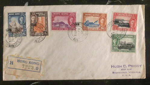
1941 Hong Kong First Day Cover FDC 100 Years British Colony Stamp Set MI 163-68Mynt Auctions4.6(680)See Sold PriceFeb 26, 2024
1940s Sudan Italian Prisoner of War POW Postcard Cover To Asmara Eritrea MedicalMynt Auctions4.6(680)See Sold PriceFeb 26, 2024
1919 Lome Togo Anglo French Occupation Gold Coast Cover to Buchs SwitzerlandMynt Auctions4.6(680)See Sold PriceFeb 26, 2024
1935 England Airmail Postcard Cover London to Njoro Kenya Colony British KUTMynt Auctions4.6(680)See Sold PriceFeb 29, 2024
AN ANTIQUE FOLDING MAP OF THE BRITISH ISLES DATED 1873Hutchinson Scott Auctioneers4.4(39)See Sold PriceFeb 28, 2024
Chatelain - 3 Maps of the British Isles (England, Ireland, Scotland)Trillium Antique Prints & Rare Books4.5(30)See Sold PriceFeb 24, 2024
De Jode, Rare, pub. 1593 - Map of the British Isles [England, Scotland, Ireland] (Angliae Scotiae etTrillium Antique Prints & Rare Books4.5(30)See Sold PriceFeb 24, 2024
Map: A 17thC engraved map of the British Isles titled A Generall Mapp of the Isles of GreatClaydon Auctioneers Ltd4.3(125)See Sold PriceFeb 26, 2024
1932 Juba Sudan First Flight Airmail Cover To Johannesburg South Africa 25 FlowMynt Auctions4.6(680)See Sold PriceMar 01, 2024
BRITISH AFRICAN COLONIES. West Africa Ascension St. Helena Mauritius 1876 mapJasper524.5(9.8k)See Sold PriceFeb 28, 2024
COLONIES FRANÇAISES en AFRIQUE. Africa Sénégal Madagascar. LEVASSEUR c1850 mapJasper524.5(9.8k)See Sold PriceFeb 28, 2024
Johnson's Africa. Colonies & tribes. Liberia Nile Delta Cape Colony 1866 mapJasper524.5(9.8k)See Sold PriceFeb 28, 2024
Stanford, Edward 1901 Large Map. Geological Map of the British IslesAlbion Auctions4.6(336)See Sold PriceMar 01, 2024
Stanford, Edward 1901 Large Map. Hydrographical Map of the British IslesAlbion Auctions4.6(336)See Sold PriceMar 01, 2024
Stanford, Edward 1901 Large Map. Stereographical Map of The British IslesAlbion Auctions4.6(336)See Sold PriceMar 01, 2024
Paterson & Mogg 1822 Pair of British Road Maps. Isle of Thanet & WightAlbion Auctions4.6(336)See Sold PriceMar 01, 2024
Paterson & Mogg 1822 Pair of British Road Maps. Rye, Eastbourne, SouthamptonAlbion Auctions4.6(336)See Sold PriceMar 01, 2024
Paterson & Mogg 1822 Pair of British Road Maps. Deal, Hythe, Shoreham, ChichesterAlbion Auctions4.6(336)See Sold PriceMar 01, 2024
6 pcs Vintage Paper Maps. Vancouver Island, British Columbia. Upper Elk Creek Sheet. See pics.Crawford Family Auctions LLC4.5(112)See Sold PriceMay 25, 2024


![De Jode, Rare, pub. 1593 - Map of the British Isles [England, Scotland, Ireland] (Angliae Scotiae et (1 of 2)](https://p1.liveauctioneers.com/6581/319571/171593327_1_x.jpg?height=282&quality=70&version=1707853304)


