Map of Cape Cod - Gray Gables, Pocasset HeightsPocasset, Grey Gables, Agawam, Cedar Pond Creek, Hen Cove, Pocasset Heights, Pocasset Harbor, Wings Neck, Wenaumet Bluffs, Barlow River, Monument Beach Road, Pocasset Village, Pocasset House, Mill PonSee Sold Price
SoldDROP-LEAF TABLE WITH CAPE COD DECORATION ContemporaryDROP-LEAF TABLE WITH CAPE COD DECORATION Contemporary In pine. Top with carved and brown-stained silhouette map of Cape Cod. White-painted stretcher base. Height 30". Length 59". Width 21.25" plus twoSee Sold Price
DROP-LEAF TABLE WITH CAPE COD DECORATION In pine. TopDROP-LEAF TABLE WITH CAPE COD DECORATION Contemporary In pine. Top with carved and brown-stained silhouette map of Cape Cod. White-painted stretcher base. Height 30". Length 59". Width 21.25" plus twoSee Sold Price
MassachusettsPublication Date: 1888 Title: Massachusetts Cartographer: BRADLEY, WM. M. Publisher: WM. M. BRADLEY & CO. Height: 18 Width: 24 Detailed map with all railroads. Cape Cod in inset. Reserve: $45.00 ShippSee Sold Price
Cape Cod, Nantucket & Martha's Vineyard. Barnstable Dukes. WALLING GRAY 1871 mapTitle: Cape Cod, Nantucket & Martha's Vineyard. Barnstable Dukes. WALLING GRAY 1871 map Description: Barnstable, Dukes, Nantucket counties' by Henry Francis Walling & Ormando Willis Gray (1871). AntiqSee Sold Price
SoldMAP, Cape Cod, Massachusetts, PaigeCape Cod, Massachusetts. Paul Paige, A Map of Cape Cod, 1940 (circa). Printed Color. This vivid pictorial map of Cape Cod is by Paul Paige of East Brewster, Massachusetts. It highlights the Cape's manSee Sold Price
SoldA. ELMER CROWELL MINIATURE KINGFISHER East Harwich,A. ELMER CROWELL MINIATURE KINGFISHER East Harwich, Massachusetts, Circa 1928 Mounted on a driftwood base. Signed on base "A.E. Crowell Cape Cod". Height 3". Length 3.5".See Sold Price
SoldEARLY 19TH CENTURY WELSH PLATE CUPBOARD purchased in CaEARLY 19TH CENTURY WELSH PLATE CUPBOARD purchased in Cape Cod height- 77", width- 56"See Sold Price
SoldJULIE A. GAWEL"HOPPER'S SILENCE 2: CAPE COD"JULIE A. GAWEL"HOPPER'S SILENCE 2: CAPE COD". Height: 13 1/2 & 9 1/2 in. by Width: 11 & 7 1/2 in.See Sold Price
SoldA. ELMER CROWELL LIFE-SIZE YELLOW WARBLER East Harwich,A. ELMER CROWELL LIFE-SIZE YELLOW WARBLER East Harwich, Massachusetts, Circa 1930 Mounted on a circular wooden base. Rectangular stamp. Signed "A.E. Crowell Cape Cod". Height 3". Length 4.5".See Sold Price
SoldPARK BENCH WITH CAPE COD DECORATION Mahogany and teakPARK BENCH WITH CAPE COD DECORATION Late 20th/Early 21st Century Mahogany and teak slats and cast iron ends painted black. Back with central carving of the outline of Cape Cod. Height 32". Length 61.5See Sold Price
SoldMatted and Framed Map of Cape CodLater copy of a 1922 map of Barnstable County, Cape Cod. View shows the entire Cape from Bourne to Provincetown. Of special interest is the coastline near Chatham and Monomoy where major changes haveSee Sold Price
SoldEarly 20th century map of Cape CodColorful early twentieth century map of Cape Cod. All major attractions are listed. Map shows Plymouth and Barnstable County. Framed. Overall dimensions 28 inches x 39 inches.See Sold Price
SoldMID-20TH CENTURY GUIDE MAP OF CAPE COD, FEATURINGEDAVILLE RAILROAD. HAND PAINTED ON BOARD. FRAMED. OVERALL SIZE 93 1/2" X 50 1/2". OVERALL GOOD CONDITION.See Sold Price
SoldDecorative map of Cape Cod, 1937, printed by TheLeBaron Bonney Co., Bradford, MA. Vibrantly colored lithograph map depicting the various towns of Cape Cod with interesting images of buoy, seagull, lighthouse buildings in the border. Tiny scuff markSee Sold Price
Map of Cape Cod - Hyannisport, CraigvilleCraigville, Craigville Beach, Lily Pond, Lake Elizabeth, Dr. TL Bennett, Hyannis Beach Association. Atlas of Cape Cod 1906: Plate 27. Publisher: George Walker, 1906. Size of Original: 32"x22" Please nSee Sold Price
Map of Cape Cod - Mashpee, Town, MAMaps of Cape Cod - Mashpee, Town, MA. Wakeby Pond, Mashpee Pond, Mashpee River, Wells Pond,Great River, Red Brook, Johns Pond, Moody Pond, Santuit Pond, Popponessett Beach. Atlas of Barnstable CountySee Sold Price
Map of Cape Cod - West Barnstable, WiannoWest Barnstable, Neck Pond, Joseph C. Stevens, Wianno, East Bay, Crystal Lake, Wianno Road, Cotocheset House, Cotocheset Company, Parker Pond, Mrs. Frank A. Day. Atlas of Cape Cod 1906: Plate 23. PublSee Sold Price
Map of Cape Cod - Santuit Village, CummaquidBarnstable Village, Main Street, Hinckley's Pond, Old Jail Lane, Commerce Road, Flax Pond, Hyannis Road, Braggs Lane, Cummaquid. Atlas of Cape Cod 1906: Plate 22. Publisher: George Walker, 1906. SizeSee Sold Price
SoldRARE LARGE 1853 WALL MAP OF CAPE COD & THE ISLANDSBY E. WALLING; 58" X 62" IN SIGHT, CONDITION ISSUES AS SEEN IN PHOTOSSee Sold Price
Sold1940's Paul Paige "A Map of Cape Cod"1940's Paul Paige Brewster Mass. "A Map of Cape Cod" 27 x 36"See Sold Price
Map of Cape Cod - Barnstable Village, MAMaps of Cape Cod - Barnstable Village, MA. Bacon Farm Grist Mill, Huckins Creek S.B Phinney, Coggins Pond, Atlas of Barnstable County 1880: Plate 36. Publisher: George H. Walker, 1880. Size of OriginaSee Sold Price
SoldFRAMED MAP OF CAPE CODFramed map of Cape Cod. Very colorful. Drawn by Clara Chase. 35H X 28WSee Sold Price
SoldU.S. Coast Survey 1853 Map of Cape Cod, MA, NH"Sketch A Shewing the progress of the Survey in Section No. 1" Electrotype Map Published 1843-65, Washington for "Report of the Superintendent of the U.S. Coast Survey..." Published under the supervisSee Sold Price
Arthur Diehl (MA,NY,UK,1870-1929) oil painting antiqueBroward Auction Gallery4.7(292)See Sold PriceMar 31, 2024
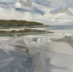
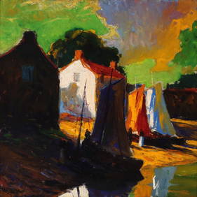
George Adomeit (American 1879-1964) CAPE COD LandscapePremier Auction Galleries4.4(331)See Sold PriceMar 09, 2024
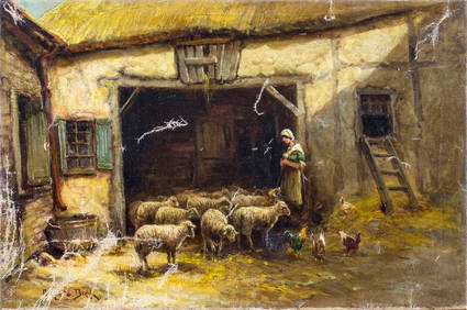
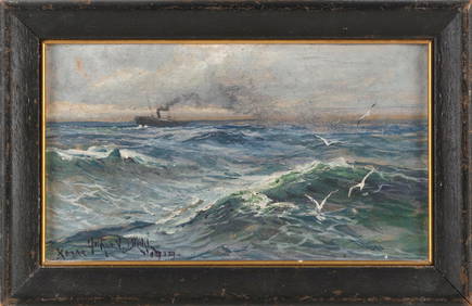
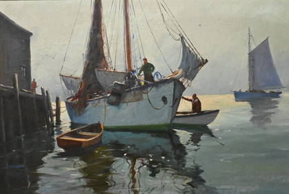
ARTHUR VIDAL DIEHL (Massachusetts/New York/England, 1870-1929), Steamship in open waters., Oil onEldred's4.7(419)See Sold PriceFeb 27, 2024
SMALL CASED MODEL OF THE TWO-MASTED "SUE B." OF CAPE COD 20th Century Case height 9.75". LengthEldred's4.7(419)See Sold PriceFeb 27, 2024
ARTISTIC CARVING CO "LOUISBURG" EAGLE by THE SHIPYARDJohn McInnis Auctioneers,LLC4.5(505)See Sold PriceFeb 25, 2024
J.J. Enwright (C. Hjalmar Amundsen) (American 1911-2001)Nadeau's Auction Gallery4.7(409)See Sold PriceFeb 24, 2024
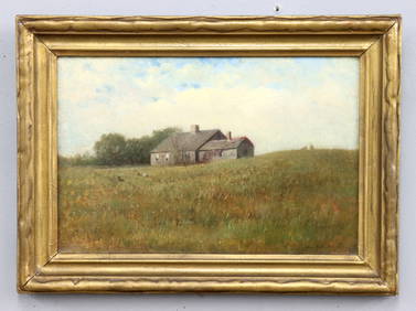
GEORGE GUSTAV ADOMEIT (1879-1967) "CAPE COD".Amelia Jeffers, Auctioneers & Appraisers4.5(120)See Sold PriceMar 07, 2024
FOUR CAPE COD WATERCOLORS 20th Century Framed from 9" x 13" to 19" x 23".Eldred's4.7(419)See Sold PriceMar 07, 2024
WEST AFRICA Explorers' routes Senegal Ashanti. Mountains of Kong. SDUK 1857 mapJasper524.5(9.9k)See Sold PriceFeb 28, 2024
WEST AFRICA explorers' routes. Beaufort Gray Park Dochard Caillie. SDUK 1874 mapJasper524.5(9.9k)See Sold PriceFeb 28, 2024
WEST AFRICA I Explorers' routes Senegal Ashanti Ivory Gold Coast. SDUK 1851 mapJasper524.5(9.9k)See Sold PriceFeb 28, 2024
WEST AFRICA showing early explorers' routes & Mountains of Kong. SDUK 1844 mapJasper524.5(9.9k)See Sold PriceFeb 28, 2024
Hermes Cape Cod Double Tour Quartz Watch Stainless Steel and Leather 29Golden Air Auctions4.4(265)See Sold PriceFeb 26, 2024
Hermes Cape Cod Double Tour Quartz Watch Stainless Steel and Leather 29Pacific Global Auction3.9(280)See Sold PriceMar 05, 2024
Hermes Cape Cod Quartz Watch Stainless Steel and Leather with Rose Sapphires, Diamonds and Mother ofPacific Global Auction3.9(280)See Sold PriceMar 05, 2024
Hermes Cape Cod Double Tour Quartz Watch Stainless Steel and Leather 29Pacific Global Auction3.9(280)See Sold PriceFeb 25, 2024