SoldYoung: Map of Minnesota Territory, 1850Map: Map of Minnesota Territory Maker: J. H. Young Publisher: Cowperthwait, DeSilver & Butler Publishing Date: 1850 (1854) "Important early map of Minnesota Territory, including all of Dakota, from thSee Sold Price
Sold15 maps (13 w/ orig. hand coloring) + 1 atlas[United States]. 15 Color Maps + 1 Facsimile Atlas. Good - very good condition. ++ J. H. Young. Map Of Minnesota Territory. Phila: Thomas Cowperthwait, (1850). 12 3/8 x 15 1/4 in. ++ 2 maps from Cram'See Sold Price
SoldMAP OF MINNESOTA TERRITORY BY J.H. YOUNG 1854Hand tinted lithograph map by J.H. Young, Cowperthwait, Desilver & Butler, 1854. Measures 14 x 17.2 inches overall. Depicts the Minnesota territory, lakes, rivers, forts, and native American tribal reSee Sold Price
SoldMap of Minnesota Territory 1854Title: Map of Minnesota Territory by J.H. Young Author: Cowperthwait, Desilver & Butler Description: Lithographed map, hand-colored. 32.7x40.7 cm. (12¾x16").Fascinating map of the lands between WiscoSee Sold Price
Map of Minnesota TerritoryTitle/Content of Map: Map of Minnesota Territory Date: 1856 Cartographer: YOUNG, J.H. Publisher: CHARLES DESILVER Size: 12Height - 15Width Scarce folding pocket map w/o covers. Details MN with DakotaSee Sold Price
Map of Minnesota TerritoryTitle: Map of Minnesota Territory Publication Date:1856 Cartographer: YOUNG, J.H. Publisher: CHARLES DESILVER Brief Description: Scarce folding pocket map w/o covers. Details MN with Dakota not labeleSee Sold Price
Minnesota territory, showing a large area of the upperTitle: Minnesota territory, showing a large area of the upper Midwestern states. RARE & important map 1850 by Thomas. Date/Period: c1850. Materials: Hand colored steel engraved Size: 16 1/2 x 13 1/2 iSee Sold Price
SoldMinnesota territory, showing a large area of the upperTitle: Minnesota territory, showing a large area of the upper Midwestern states. RARE & important map 1850 by Thomas Date/Period: c1850 Materials: Hand colored steel engraved Size: 16 1/2 x 13 1/2 incSee Sold Price
Minnesota territory, showing a large area of the upperTitle: Minnesota territory, showing a large area of the upper Midwestern states. RARE & important map 1850 by Thomas. Date/Period: c1850 Materials: Hand colored steel engraved Size: 16 1/2 x 13 1/2 inSee Sold Price
Minnesota territory, showing a large area of the upperTitle: Minnesota territory, showing a large area of the upper Midwestern states. RARE & important map 1850 by Thomas. Date/Period: c1850. Materials: Hand colored steel engraved Size: 16 1/2 x 13 1/2 iSee Sold Price
Sold[Minnesota Territory, Exploration]REPORT OF THE SECRETARY OF WAR, COMMUNICATING THE REPORT OF AN EXPLORATION OF THE TERRITORY OF MINNESOTA, BY BREVET CAPTAIN POPE. [Washington], 1850. Senate Issue, 31st Congress, 1st Session. 8vo. 56See Sold Price
1854 map of Minn. Terr. – Cowperthwait, Desilver,An essential map for Minnesota and Dakota collectors. One of the earliest editions of the map, first issued in 1850, the year after Minnesota became a territory. Scarcer version published by CowperthwSee Sold Price
1854 map of Minn. Terr. – Cowperthwait, Desilver,An essential map for Minnesota and Dakota collectors. One of the earliest editions of the map, first issued in 1850, the year after Minnesota became a territory. Scarcer version published by CowperthwSee Sold Price
1854 map of Minn. Terr. – Cowperthwait, Desilver, ButlerAn essential map for Minnesota and Dakota collectors. One of the earliest editions of the map, first issued in 1850, the year after Minnesota became a territory. Scarcer version published by CowperthwSee Sold Price
SoldExploration of Minnesota with map 1850Heading: Author: Pope, John Title: Report of the Secretary of War, Communicating the report of an exploration of the Territory of Minnesota, by Brevet Captain Pope Place Published: Washington PublishSee Sold Price
SoldExploration of Minnesota with map 1850Heading: Author: Pope, John Title: Report of the Secretary of War, Communicating the report of an exploration of the Territory of Minnesota, by Brevet Captain Pope Place Published: Washington PublishSee Sold Price
SoldMitchells National Map of The American Territories1850, Philadelphia. The map retains its original painted wood roller. Drawn by J.H. Young and engraved by J.H. Brightly the map gives excellent detail of the East Coast and several interior states. FuSee Sold Price
Sold1850 Meyer Mid-continent statesReserve Reduced! Scarce regional map of the upper Midwest from Meyer's Zeitungs-Atlas. Minnesota still labeled as Sioux Territory. Highly detailed map shows towns, rivers, lakes, roads, railroads, canSee Sold Price
Map of Minnesota Territory 1855Map Title: Map of Minnesota Territory Date: 1855 Publisher: Cowperthwait, DeSilver, & Butler: Philadelphia Size: 12.75 x 16 inches Map with 36 counties separately colored. Also towns and townships, InSee Sold Price
Scarce 1855 Minn. - Colton’s Atlas of the WorldImportant early atlas map of Minnesota Territory, immediately after the creation of Dakota Territory. This map appeared in the 1856 Colton 2-volume Atlas of the World. Map is by Johnson & Browning. ItSee Sold Price
Scarce 1855 Minn. - Colton’s 1856 Atlas of the WorldReserve Reduced! Important early atlas map of Minnesota Territory, immediately after the creation of Dakota Territory. This map appeared in the 1856 Colton 2-volume Atlas of the World. Map is by JohnsSee Sold Price
SoldTwo Maps of Utah Territory, 1850[Two Antique Maps of Utah Territory], "Map of the Great Salt Lake and Adjacent Country in the Territory of Utah..." and "Map of a Reconnaissance between Fort Leavenworth on the Missouri River, and theSee Sold Price
Scarce Cowperthwait, Desilver, Butler map of TexasScarce map of Texas by J.H. Young. “Map of the State of Texas from the Latest Authorities by J. H. Young.” 1850 map from an early 1855 edition of the Cowperthwait, Desilver & Butler New UniversalSee Sold Price
SoldScarce Cowperthwait, Desilver, Butler map of TexasScarce map of Texas by J.H. Young. “Map of the State of Texas from the Latest Authorities by J. H. Young.” 1850 map from an early 1855 edition of the Cowperthwait, Desilver & Butler New UniverSee Sold Price
Ohio and Pennsylvania RR 2nd Annual Report-March 4, 1850JM Hobby Supply and Railroad Artifact Auctions4.4(126)See Sold PriceFeb 24, 2024
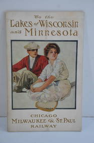
Chicago Milwaukee and St Paul RY To the Lakes of Wisconsin and Minnesota Book-1909JM Hobby Supply and Railroad Artifact Auctions4.4(126)See Sold PriceFeb 24, 2024
Kunichika and Kyosai "Kyoto Gojabashi" Wood Block Ca. 1850Cowboy Joe's Antiques4.7(189)See Sold PriceFeb 27, 2024
Nottingham.- Ordnance Survey Office (publisher) Collection 8 geological maps on the environs ofForum Auctions4.3(52)See Sold PriceFeb 29, 2024
Attributed to Léon Comerre (1850-1916) - portrait of a young WomanAlma4.3(59)See Sold PriceMar 03, 2024
North & West Africa. Dahomey. Gold Coast. Military Territory. THE TIMES 1922 mapJasper524.5(9.8k)See Sold PriceFeb 28, 2024
Carte de L'Algérie et de la Régence de Tunis' ANDRIVEAU-GOUJON Algeria 1850 mapJasper524.5(9.8k)See Sold PriceFeb 28, 2024
Fifteen American Fiddleback Coin Silver Spoons by Various MakersGray's Auctioneers4.5(186)See Sold PriceMar 06, 2024
Theo. Hamm Brewing Co. St. Paul Birds Eye Factory MapMatthew Bullock Auctioneers4.7(1.8k)See Sold PriceMar 02, 2024
Francis McNally - Antique Map of California & MinnesotaProverde Auctions4.3(3)See Sold PriceFeb 28, 2024
Robert H Labberton - Map of The Territory of the Present United States - The territory of theProverde Auctions4.3(3)See Sold PriceFeb 28, 2024
The Kingdom of Dalmatia Territories Map, 1700Antiques Online Auctions4.6(407)See Sold PriceMar 14, 2024
Chelsea Gold Anchor Porcelain Figure, Young Pedler Ca. 1850, H 5.7"DuMouchelles4.6(825)See Sold PriceMar 14, 2024


![[Minnesota Territory, Exploration] (1 of 3)](https://p1.liveauctioneers.com/3532/125343/63770413_1_x.jpg?height=282&quality=70&version=1532476745)