Howe: Map of the Great West, 1853Map Title: Map of the Great West Maker: Henry Howe Publishing Date: 1853 Size: Octavo - 4.30 x 7.80 inches Stylized map of the western United States showing a large Mormon territory, "Utah or Deseret"See Sold Price
SoldHenry Howe HISTORICAL COLLECTIONS OF THE GREAT WESTHenry Howe HISTORICAL COLLECTIONS OF THE GREAT WEST 1857 Decorative Leather Binding Gilt Marbled Page Edges Illustrated India-Tinted Engravings Maps Western US History Frontier Oregon New Mexico TexasSee Sold Price
SoldBurgess: Antique Map of the United States & Canada 1853Map of the United States and Canada, Burgess 1853. Great map of the U. S. during the transitional period of the American West. Most of the western lands are shown as large territories: Minnesota, NebrSee Sold Price
SoldHowe, [...The Great West]Henry Howe, [Historical Collections of the Great West,] New York, 1857, Volume I only, illustrated with 36 India-tinted engravings, rebacked tooled and elaborately gilt-decorated black leather with maSee Sold Price
SoldThe Great West As It Was and As It Is; HoweFor your consideration is this copy of Henry Howe's "The Great West As It Was and As It Is". The work discusses the discovery and development of the lands mostly west of the Mississippi and has historSee Sold Price
The Great West As It Was and As It Is; HoweFor your consideration is this copy of Henry Howe's "The Great West As It Was and As It Is". The work discusses the discovery and development of the lands mostly west of the Mississippi and has historSee Sold Price
SoldMitchell's map of the west 1853Heading: Author: Mitchell, Samuel Augustus Title: A New Map of the State of California, the Territories of Oregon, Washington, Utah & New Mexico... Place Published: Philadelphia Publisher:Thomas, CowSee Sold Price
Tallis: Antique Map of West Indies, 1853Title/Content of Map: West Indies by Tallis, circa 1853 (featuring Jamaica) Date Printed: 1853 Cartographer: John Tallis Material/Medium: Lithograph Dimensions: 10 3/4" x 13 3/4" Original lithograph bSee Sold Price
Scarce 1856 Map of the Great West, still in bookScarce and fascinating early map of the Plains, Midwest and Rocky Mountains, drawn by E.F. Beadle and published by Miller, Orton & Mulligan in “The States and Territories of the Great West.” Map eSee Sold Price
SoldHistorical Collections of the Great West. Howe.HOWE, Henry. Historical Collections of the Great West: Containing Narratives of the Most Important and Interesting Events in Western History - Remarkable Individual Adventures - Sketches of Frontier LSee Sold Price
Mitchell's map of the west 1853Heading: Author: Mitchell, Samuel Augustus Title: A New Map of the State of California, the Territories of Oregon, Washington, Utah & New Mexico... Published by Thomas, Cowperthwait & Co. Place PubliSee Sold Price
SoldHowe, Henry: The Great West: 1858Howe, Henry. The Great West: containing narratives of the most important and interesting events in western history - remarkable individual adventures - sketches of frontier life - descriptions of natuSee Sold Price
SoldMitchell's map of the west 1853Heading: Author: Mitchell, Samuel Augustus Title: A New Map of the State of California, the Territories of Oregon, Washington, Utah & New Mexico... Published by Thomas, Cowperthwait & Co. Place PubliSee Sold Price
Sold4 vols. The American West - Description & Travel4 vols. The American West - Description & Travel: Howe, Henry. The Great West. New York; Cincinnati, 1859. 8vo, orig. full publisher's black morocco, gilt; extremities rubbed, spine ends heavily rubbeSee Sold Price
SoldBeadle (J.H.) Life in UtahBeadle (J.H.) Life in Utah; or, the Mysteries and Crimes of Mormonism,folding map, illustrations, Philadelphia, [1870] § Parkman (F.) The Discovery of the Great West, map, 1869 § Drumm (S., edSee Sold Price
SoldThe Great West by Howe, 1851. Vol. 1& Beyond the Mississippi by Richardson, 1867. Poor condition. Missing cover & bad bindingsSee Sold Price
Railroad to the Great West with map 1871Title: The Chesapeake and Ohio Railroad as a short, economical, and profitable line from the Atlantic Coast to the Great West. Its present position, peculiar advantages, and future prospects, togetherSee Sold Price
Map of The West Indies 1853Map of The West Indies Hand colored. Cartographer: Jules Sherman Smith Publisher Daniel Burgess Dated: 1853 Type: Hand Colored Lithograph Dimensions: 12 x 9 1See Sold Price
SoldLOT (2) VOLUMES CALIFORNIA/OREGONLOT (2) VOLUMES INCLUDING NORTHERN CALIFORNIA, OREGON & THE SANDWICH ISLANDS, CHARLES NORDHOFF, 1874 & THE GREAT WEST, HENRY HOWE, 1857 (VOL.I) WITH COLORED ENGRAVINGS (BROKEN BOARD)See Sold Price
Richardson 1872 Texas Alamanac MapRichardson 1872 Texas Alamanac Map with inset of “The Great West” 355. [MAP]. RICHARDSON, W[illard]. RichardSee Sold Price
SoldHall's Great West with hand-colored map, 1866Heading: Author: Hall, Edward Hepple Title: The Great West: Railroad, Steamboat, and Stage Guide and Hand-Book for Travellers, Miners, and Emigrants to the Western, Northwestern, and Pacific States aSee Sold Price
SoldFremont's great map of the West 1846Title: Map of an Exploring Expedition to the Rocky Mountains in the Year 1842 and to Oregon & North California in the years 1843-44... Author: Frémont, John Charles Description: Lithographed map, witSee Sold Price
SoldFremont's great map of the West 1846Title: Map of an Exploring Expedition to the Rocky Mountains in the Year 1842 and to Oregon & North California in the years 1843-44...Frémont, John Charles Author: Frémont, John Charles & Charles PrSee Sold Price
SoldFremont's great map of the West 1846Title: Map of an Exploring Expedition to the Rocky Mountains in the Year 1842 and to Oregon & North California in the years 1843-44... Author: Frémont, John Charles Description: Lithographed map, witSee Sold Price
Northern Pacific RR Washington and Northern Idaho Map Folder-1941JM Hobby Supply and Railroad Artifact Auctions4.4(127)See Sold PriceFeb 24, 2024
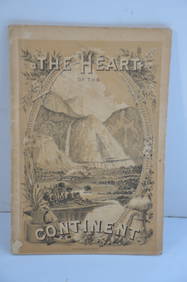
Chicago Burlington and Quincy RR The Heart of the Continent Book-1882JM Hobby Supply and Railroad Artifact Auctions4.4(127)See Sold PriceFeb 24, 2024
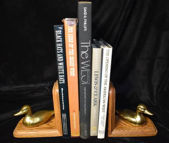
5 Folio Size Books about the West in Fine or Near Fine ConditionNorth American Artifact Auctions4.7(198)See Sold PriceApr 20, 2024
Hist. of Indian wars of the Far West - Massacres of the MountainsJasper524.5(9.9k)See Sold PriceFeb 27, 2024
WEST AFRICA Explorers' routes Senegal Ashanti. Mountains of Kong. SDUK 1857 mapJasper524.5(9.9k)See Sold PriceFeb 28, 2024
West Africa by Arrowsmith & Lewis 1812 old antique vintage map plan chartJasper524.5(9.9k)See Sold PriceFeb 28, 2024
WEST AFRICA explorers' routes. Beaufort Gray Park Dochard Caillie. SDUK 1874 mapJasper524.5(9.9k)See Sold PriceFeb 28, 2024
WEST AFRICA. French. Gold Coast Ghana. inset Gambia; Sierra Leone 1920 mapJasper524.5(9.9k)See Sold PriceFeb 28, 2024
CAP VERT. French/Portuguese Guinea Gambia Senegal Sierra Leone 1947 old mapJasper524.5(9.9k)See Sold PriceFeb 28, 2024
WEST AFRICA I Explorers' routes Senegal Ashanti Ivory Gold Coast. SDUK 1851 mapJasper524.5(9.9k)See Sold PriceFeb 28, 2024
NIGERIA explorers' routes. Lander Clapperton Oudney Denham Allen. SDUK 1874 mapJasper524.5(9.9k)See Sold PriceFeb 28, 2024
Colonial & French West Africa. Gold Coast Dahomey Upper Volta. TIMES 1922 mapJasper524.5(9.9k)See Sold PriceFeb 28, 2024
Colonial West Africa. Nigeria Cameroon Congo. British German. TIMES 1900 mapJasper524.5(9.9k)See Sold PriceFeb 28, 2024
NIGERIA early explorers' routes. Lake Chad. Yariba Houssa Borgou SDUK 1844 mapJasper524.5(9.9k)See Sold PriceFeb 28, 2024
NIGERIA w/ early explorers' routes. Lake Chad Yariba Houssa Borgou.SDUK 1844 mapJasper524.5(9.9k)See Sold PriceFeb 28, 2024
Colonial West Africa. Nigeria Cameroon Congo. British German. TIMES 1895 mapJasper524.5(9.9k)See Sold PriceFeb 28, 2024
Cooke, George 1801 Antique Map. West Indies CaribbeanAlbion Auctions4.6(341)See Sold PriceMar 01, 2024
Blackie (Pub) 1882 Folio Map. West USA - Pacific StatesAlbion Auctions4.6(341)See Sold PriceMar 01, 2024
Blackie (Pub) 1882 Folio Map. West India Islands & Central AmericaAlbion Auctions4.6(341)See Sold PriceMar 01, 2024


![Howe, [...The Great West] (1 of 3)](https://p1.liveauctioneers.com/33/39968/17154800_1_x.jpg?height=282&quality=70&version=1366317164)