Soldc. 1781, Five Maps of Northwest AmericaMapsc. 1781, Five Maps of Northwest America, Choice Very Fine. Published in London by Alexander Hogg for use as illustrations in books describing Capt. James Cook’s voyages. Each map is disboundSee Sold Price
Soldc. 1781, Five Maps of Northwest AmericaMaps Five Revolutionary War Era Maps of Northwest America c. 1781, Five Maps of Northwest America, Choice Very Fine. Published in London by Alexander Hogg for use as illustrations in books describingSee Sold Price
Soldc. 1781, Five Maps of Northwest AmericaMapsc. 1781, Five Maps of Northwest America, Choice Very Fine. Published in London by Alexander Hogg for use as illustrations in books describing Capt. James Cook’s voyages. Each map is disboundSee Sold Price
Soldc. 1781, Five Maps of NW Americac. 1781, Five Maps of Northwest America, Choice Very Fine. Published in London by Alexander Hogg for use as illustrations in books describing Capt. James Cook’s voyages. Each map is disbound andSee Sold Price
SoldFive Maps of Northwest America, c. 1781Maps Five Revolutionary War Era Maps of Northwest America c. 1781, Five Maps of Northwest America, Choice Very Fine. Published in London by Alexander Hogg for use as illustrations in books describingSee Sold Price
SoldFive Maps of Northwest America, c. 1781MapsFive Captain Cook Voyage Maps of Northwest America c. 1781, Five Maps of Northwest America describing Capt. James Cook’s voyages, Choice Very Fine. Published in London by Alexander Hogg forSee Sold Price
SoldFive Maps of Northwest America, c. 1781Historic MapsFive Captain Cook Voyage Maps of Northwest America c. 1781, Five Maps of Northwest America describing Capt. James Cook's voyages, Choice Very Fine. Published in London by Alexander HoSee Sold Price
SoldFive Maps of Northwest America, c. 1781Historic MapsFive Captain Cook Voyage Maps of Northwest America c. 1781, Five Maps of Northwest America describing Capt. James Cook's voyages, Choice Very Fine. Published in London by Alexander HoSee Sold Price
SoldFive Maps of Northwest America, c. 1781Maps Five Revolutionary War Era Maps of Northwest America c. 1781, Five Maps of Northwest America, Choice Very Fine. Published in London by Alexander Hogg for use as illustrations in books describingSee Sold Price
SoldFive Maps of Northwest America, c. 1781Historic MapsFive Captain Cook Voyage Maps of Northwest America c. 1781, Five Maps of Northwest America describing Capt. James Cook's voyages, Choice Very Fine. Published in London by Alexander HoSee Sold Price
SoldFive Maps of Northwest America, c. 1781Historic MapsFive Captain Cook Voyage Maps of Northwest America c. 1781, Five Maps of Northwest America describing Capt. James Cook’s voyages, Choice Very Fine. Published in London by AlexanderSee Sold Price
SoldFive Maps of Northwest America, c. 1781MapsFive Captain Cook Voyage Maps of Northwest America c. 1781, Five Maps of Northwest America describing Capt. James Cook’s voyages, Choice Very Fine. Published in London by Alexander Hogg forSee Sold Price
SoldFive Maps of Northwest America, c. 1781Historic MapsFive Captain Cook Voyage Maps of Northwest America c. 1781, Five Maps of Northwest America describing Capt. James Cook's voyages, Choice Very Fine. Published in London by Alexander HoSee Sold Price
SoldGrp: 5 Maps of Brazil Blaeu Bellin KitchinGroup of five 17th to 19th c. maps of South America and the Caribbean. Thomas Kitchin (1719-1784) map of the Caribbean, "A New Map of the Caribbee Islands in America 1761" London, 1761; Jacques-NicolaSee Sold Price
SoldGrp: 5 Maps of Brazil Blaeu Bellin KitchinGroup of five 17th to 19th c. maps of South America and the Caribbean. Thomas Kitchin (1719-1784) map of the Caribbean, "A New Map of the Caribbee Islands in America 1761" London, 1761; Jacques-NicolaSee Sold Price
SoldMoll maps of South America & West IndiesHeading: Author: Moll, Herman Title: Five maps by Herman Moll of South America and West Indian islands, etc. Place Published: London Publisher: Date Published: c.1732 or later DescriptSee Sold Price
SoldMAPS, 2, 19TH C., 12" X 16", CANADA & MICHIGANMAPS, TWO, 19TH C., 12" X 16", CANADA & MICHIGAN:Including 1 engraved by J. & C. Walker, "North America: Sheet V, The North West and Michigan Territories", published by Baldwin & Cradock, 1833, 12 1/2See Sold Price
Van Keulen Map of Northwest PassagePascaarte vande Noorder Zeekulten van America. Gerard Van Keulen (1654-1715). Engraving with hand color in outline. Amsterdam, c. 1700. 17 3/4 x 22 1/2 inches. An impressive sea chart showing the areaSee Sold Price
SoldVisscher America Wall MapNicolaes Visscher II (1649-1702). Nova totius Americae tabula. Amsterdam: Pieter Schenk II (c.1710). Wall map on 2 engraved sheets with additional banner title across the top and five engraved views aSee Sold Price
1781 Travels Through North America Carver Plates & MapRARE “Travels Through the Interior Parts of North America in the years 1766,1767, and 1768 by J. Carver, Esq. …The Third Edition”, printed at London for C. Dilly , H. Payne, and J. Phillips, MDCSee Sold Price
SoldA New Map... Western Territory, Kentucky...[United States/Old Northwest]. A New Map Of Part Of The United States Of North America, Exhibiting the Western Territory, Kentucky, Pennsylvania, Maryland, Virginia, &c. Also the Lakes Superior, MichiSee Sold Price
SoldMAPS OF THE MIDWEST & ONTARIO, THREEMAPS OF THE MIDWEST & ONTARIO, THREE:Including "North America,Sheet V The North West and Michigan Territories" [J & C Walker] 13" X 16", "Michigan" Entered according to Act of Congress 1844 South EastSee Sold Price
SoldSDUK 1833 Wisconsin & Michigan“North America/ Sheet V The North West and Michigan Territories.” London: Society for the Diffusion of Useful Knowledge, 1833. 11 7/8 x 15. Engraving by J. & C. Walker. Very good condition. PleaseSee Sold Price
SoldChart Of The North West Passage Between Asia...[Polar Regions/Northwest Passage]. [Philip]. Chart Of The North West Passage Between Asia & America. Double-page map, 20” x 23 ¼”, color. Liverpool: George Philip and Son, n. d. [c. 1853-56], priSee Sold Price
LATE 17TH C. FRENCH MAP OF THE NEW WORLD BY ALEXIS-HUBERT JAILLOT (1632-1712)Thomaston Place Auction Galleries4.4(386)See Sold PriceFeb 24, 2024
18TH C. ANTIQUE MAP: FRENCH & INDIAN WAR, FRAMEDThomaston Place Auction Galleries4.4(386)See Sold PriceFeb 24, 2024
Two (2) Antique 18th C. Copper Engraved Framed Maps - America & EuropeMagnusson Art Group4.5(46)See Sold PriceMar 14, 2024
North-west Africa. Morocco &c. Sahara desert. Unresolved borders. TIMES 1922 mapJasper524.5(9.8k)See Sold PriceFeb 28, 2024
1675: ANTIQUE ILLUSTRATED JULIUS CAESAR MAPS OF ROMAN HISTORYNY Elizabeth 4.3(84)See Sold PriceMar 03, 2024
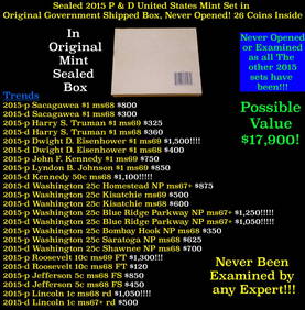
Sealed 2015 United States Mint Set in Original Government Shipped Box, Never Opened! 28 CoinsKey Date Coins4.2(1.2k)See Sold PriceFeb 24, 2024
Sealed 2015 United States Mint Set in Original Government Shipped Box, Never Opened! 28 CoinsKey Date Coins4.2(1.2k)See Sold PriceFeb 26, 2024
Sealed 2017 United States Mint Set in Original Government Shipped Box, Never Opened! 20 CoinsKey Date Coins4.2(1.2k)See Sold PriceFeb 25, 2024
Sealed 2017 United States Mint Set in Original Government Shipped Box, Never Opened! 20 CoinsKey Date Coins4.2(1.2k)See Sold PriceFeb 24, 2024
Sealed 2017 United States Mint Set in Original Government Shipped Box, Never Opened! 20 CoinsKey Date Coins4.2(1.2k)See Sold PriceFeb 24, 2024
Sealed 2015 United States Mint Set in Original Government Shipped Box, Never Opened! 28 CoinsKey Date Coins4.2(1.2k)See Sold PriceFeb 25, 2024
Sealed 2015 United States Mint Set in Original Government Shipped Box, Never Opened! 28 CoinsKey Date Coins4.2(1.2k)See Sold PriceFeb 25, 2024