SoldLapie map of Africa 1831Heading: Author: Lapie, Le Chevalier Title: Carte d'Afrique Place Published: Paris Publisher: Date Published: 1831 Description: Engraved map, hand-colored in outline. 39.2xSee Sold Price
Sold1831 Teesdale Map of Africa -- AfricaTitle/Content of Map: 1831 Teesdale Map of Africa -- Africa Date: 1831, LondonCartographer: H Teesdale Size: 16.1 X 13.2 in. This is a very nice map of Africa.Plenty of detail is offered mostly alongSee Sold Price
1831 Teesdale Map of Africa -- AfricaTitle/Content of Map: 1831 Teesdale Map of Africa -- Africa Date: 1831, London Cartographer: H Teesdale Size: 16.1 X 13.2 in. This is a very nice map of Africa. Plenty of detail is offered mostly alonSee Sold Price
Woodbridge's Antique Map of South America & Africa 18311831 map of South America & Africa for Woodbridge's Geography, hand colored engraving. A hand colored engraved map of South America and Africa printed in 1831 for Woodbridge's Geography atlas. The fulSee Sold Price
LAPIE ORIGINAL ANTIQUE MAP ASIA MINOR 1831L' ASIE MINEURE 1831 SIZE: 25.5 X 20 INCHES APPROX. UNFRAMEDSee Sold Price
LAPIE ORIGINAL ANTIQUE MAP ASIA MINOR 1831L' ASIE MINEURE 1831 SIZE: 25.5 X 20 INCHES APPROX. UNFRAMEDSee Sold Price
Sold3 Maps incl: AFRICA, Lon: Teesdale & Co., 1831.[Afghanistan/Africa]. 3 Maps. Matted and framed under glass, not examined out of frame. ++ Africa. Margin at lower right: “Drawn Engraved by J. Dowre, Fentonville, London.” Center of lower margin:See Sold Price
Soldtwo early 19th c French maps of Africatwo early 19th c French maps of Africa- 1820 Carte de L'Afrique by Brue, 2 sheet hand colored map of Africa, 21" x 26 3/4", 7& 1837 Carte D'Afrique by Lapie, 2 sheet hand colored map of Africa, 19 3/4See Sold Price
S.D.U.K Antique Map of AfricaDescription: Beautiful example of an 1831 Society for the Diffusion of Useful Knowledge or S.D.U.K. map of Africa. This map was originally published by Baldwin and Cradock and copyrighted in 1831, butSee Sold Price
SoldVarious. 28 maps of Africa. c.19th century.[Africa] 28 maps. Various maps of Africa mostly 19th century. (1) Lapie. “Afrique Ancienne.” 1812. (2) Johnston. “Egypt and Arabia Petraea.” c.1850. (3) Harrison. “EgyptSee Sold Price
1831 Woodbridge Map of South America and Africa -- Comparative, Geographical & Statistical Map ofTitle: 1831 Woodbridge Map of South America and Africa -- Comparative, Geographical & Statistical Map of South America & Africa Cartographer: W. Woodbridge Year / Place: 1831, Hartford Map Dimension (See Sold Price
North Africa Or Barbary. II.Title: North Africa Or Barbary. II. Date: 1834-09-01 Cartographer: WALKER, J. & C. Publisher: Baldwin & Cradock/S.D.U.K. Description: Algier. Based on authorities Shaw, Smyth, Rozet, Lapie, Garnier, BSee Sold Price
Sold* DU CHAILLU, Paul Belloni (1831-1903). A Journey to* DU CHAILLU, Paul Belloni (1831-1903). A Journey to Ashango-Land: and Further Penetration into Equatorial Africa. London: John Murray, 1867. 8vo. Frontispiece, folding route map, numerous wood-engravSee Sold Price
Sold* CHAPMAN, James (1831-1872). Travels in the Interior* CHAPMAN, James (1831-1872). Travels in the Interior of South Africa, comprising Fifteen Years' Hunting and Trading; with journeys across the continent from Natal to Walvisch Bay, and visits to LakeSee Sold Price
SoldPanckoucke (C.L.F.) - Carte Générale des Victoires etmap of Europe, the Near East and North Africa, with 16 inset city plans, lower left, engraved map, 650 x 925mm., dissected and linen-backed, lacking slipcase, 1821 § Lapie (Pierre) Carte du RoyaumeSee Sold Price
Hooker: Lower and Midtown Manhattan Map, 1831Map: 1831 Hooker Lower and Midtown Manhattan Map -- Map of the City of New York Cartographer: W Hooker Year / Place: 1871 reissue, New York City Map Dimensions: 15.4 x 12.2 in. Nicely color outlined MSee Sold Price
SoldTallis, John (Pub) 1852 Map. AfricaSteel Engraved Map with Original Outline Hand Color Published 1852-56 by John Tallis, London for "The Universal Pronouncing Dictionary" by Thomas Wright. Drawn & Engraved by John Rapkin. Centre fold aSee Sold Price
Hooker Lower and Midtown Manhattan Map, 18311831 Hooker Lower and Midtown Manhattan Map -- Map of the City of New York. Nicely color outlined Map of the City of New York. Interestingly, the orientation of the title and of the map are in 180 degSee Sold Price
SoldLochhead (Pub) 1811 Rare Map. AfricaCopper Engraved Map Published 1811 by William Lochhead, Berwick for "Modern Geography: And a Compendious General Gazetteer" Rare. Folds as issued. Paper Size: 12 x 10 inch (30 x 26cm) Very minor toninSee Sold Price
SoldBarclay, James C1835 Hand Col Map. Africa ContinentHand Colored Copper Engraved Map Published C1835, London for "A Complete and Universal English Dictionary" by the Rev. James Barclay et al. Folds as issued. Paper Size: 11 x 8.5 inch (28 x 22cm) GoodSee Sold Price
SoldBarclay, James 1809 Hand Col Map. Africa ContinentHand Coloured Copper Engraved Map Published 1809, Leeds for "Barclay's Complete and Universal Dictionary of the English Language..." by the Rev. James Barclay. Folds as issued. Paper Size: 11 x 10 incSee Sold Price
SoldCarte de Etas-Unis de Mexique Lapie MapCarte de Etas-Unis de Mexique. Alexander Emile Lapie (d. 1851). from Atlas Universel. Copper-plate engraving with original hand color in outline. Paris, 1838. 22 1/2 x 16 inches visible, 33 1/2 x 26 iSee Sold Price
SoldGuthrie, William 1798 Map. Africa ContinentCopper Engraved Map Published 1798, London for "A New Geographical, Historical and Commercial Grammar..." by William Guthrie. The maps are by John Senex, Thomas Kitchin and others. Folds as issued. PaSee Sold Price
SoldLapie, Map of the U.S., EngravingAlexandre Emile Lapie, "Carte des Etates-Unis d'Amerique," hand-colored engraving, made in Paris 1842, incorporates details from the exploration of Lewis and Clark, Long and others, depicts Texas as aSee Sold Price
Carte de la Barbarie… l'empire de Maroc… North Africa Morocco. LAPIE 1829 mapJasper524.5(9.8k)See Sold PriceFeb 28, 2024
AFRICA. French West Africa. Rio de Oro Rio Muni Nigeria. BARTHOLOMEW 1952 mapJasper524.5(9.8k)See Sold PriceFeb 28, 2024
AFRICA. Map pre-dating much exploration. Mountains of Kong. SDUK 1851 oldJasper524.5(9.8k)See Sold PriceFeb 28, 2024
AFRICA. Antiqua; Rome Carthage, start Punic War 1908 old antique map chartJasper524.5(9.8k)See Sold PriceFeb 28, 2024
Pre-colonial Africa. Mountains of Kong/Moon. Caravan routes. THOMSON 1817 mapJasper524.5(9.8k)See Sold PriceFeb 28, 2024
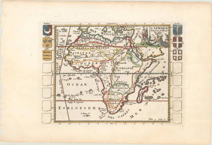
Carte d'Afrique. Africa Soudan Zanzibar. LAPIE 1831 old antique map plan chartJasper524.5(9.8k)See Sold PriceFeb 28, 2024
AFRICA. Africa. Britannica 9th edition 1898 old antique vintage map plan chartJasper524.5(9.8k)See Sold PriceFeb 28, 2024
Pre-SECOND WORLD WAR AFRICA. European colonies & German mandates 1942 old mapJasper524.5(9.8k)See Sold PriceFeb 28, 2024
Carte de l'Afrique propre, de la Numidie… North Africa. LAPIE 1829 old mapJasper524.5(9.8k)See Sold PriceFeb 28, 2024
NORTH EAST AFRICA. Libya Egypt Sudan Ethiopia Ubangi-Shari Chad 1952 old mapJasper524.5(9.8k)See Sold PriceFeb 28, 2024
ANCIENT NORTH AFRICA Septentrionalis. Mauretania Tripolitana ARROWSMITH 1828 mapJasper524.5(9.8k)See Sold PriceFeb 28, 2024