MAP - PIETER SCHENK / VALK / JANSSEN Hand Colored superb Map Central Italy c1702Luis Porretta Fine Arts4.3(10)See Sold PriceMar 02, 2024
CHARLES ROLLIN c1828 Ceasar Hand Colored Africa Military MapLuis Porretta Fine Arts4.3(10)See Sold PriceMar 02, 2024
MAP - Dufour, A. H. ( Malte / Brun ) :MAP - ESPAGNE PARTIE SUD DIVISEE EN PROVINCES ANCIENNES ( MAPLuis Porretta Fine Arts4.3(10)See Sold PriceMar 02, 2024
RIGOBERT BONNE c1787 Original Colored Map Germany & Region 15" x 12"Luis Porretta Fine Arts4.3(10)See Sold PriceMar 02, 2024
AMBROISE TARDIEU c1822 Napoleonic War Map GermanyLuis Porretta Fine Arts4.3(10)See Sold PriceMar 02, 2024
MAP - AMBROISE TARDIEU c1822 Napoleonic Miltary Map GermanyLuis Porretta Fine Arts4.3(10)See Sold PriceMar 02, 2024
1822 Rare Map by Ambroise Tardieu Napoleon Caldiero Battle of Vento 17" x 11Luis Porretta Fine Arts4.3(10)See Sold PriceMar 02, 2024
PIETER SCHENK / VALK / JANSSEN Hand Colored Map of Rhodes Greece ca1702 vgcLuis Porretta Fine Arts4.3(10)See Sold PriceMar 02, 2024
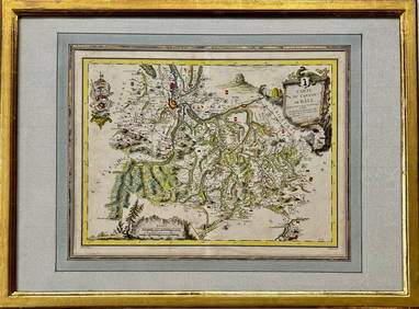
Map: Carte du Canton de Bale, Jacques Clermont, Paris, 1788Kensington Estate Auction4.6(216)See Sold PriceFeb 26, 2024
Carte De L'amerique, 18th CenturyMap: Carte De L'amerique Maker: Anonymous Size: Octavo - 7.5 inches high x 5.5 inches wide Date: Mid 18th century Origin: France Shows the Gila River crossing the Colorado River. Unknown lands north oSee Sold Price
SoldFrench Carte De L'amerique Map, 1750Map: Carte De L'amerique Publication Date: 1750 ca. Authors: ANONYMOUS Size: Octavo – 7.50 H x 5.50 W Inches Mid 18th Century French "L'Amerique." Shows the Gila River crossing the Colorato River. USee Sold Price
Sold18th century Chatelain map18th century Chatelain map, North America, "Nouvelle Carte De L'Amerique…", from "Atlas Historique", Henry Abraham Chatelain, Amsterdam, 1723-1733, California shown as a peninsula, Florida shown extSee Sold Price
Bellin: Amerique Meridionale, Map of South America 1758Map Title: 'Carte de l'Amerique Meridionale Pour l'Histoire Générale des Voyages in 8o.' Date Printed: 1758 Size: Approx 46.5 x 35.0cm, 18.25 x 13.75 inches (Large); Type: Antique 18th century coppeSee Sold Price
Sold18th C Map of South AmericaEarly 18th century map of South America, hand colored outline, Carte de LAmerique Meridionale Dressee Survant les Nouvelles Observations de Mrs. De lAcademie Royale des Sciences. Laid down on paper, mSee Sold Price
SoldFrench 18th Century ''Carte Patriculiere de la Cote DuFrench 18th Century ''Carte Patriculiere de la Cote Du Nord-Ouest de L'Amerique'' Map Engraving 20.5''x28'' Sight. Dated 1786 map from the Atlas du Voyage de la Perouse. Gallery framed 28''x35''. ScatSee Sold Price
SoldTwo French Maps of the Americas18th century: "[Carte Du Golphe Du Mexique et des Isles De L'Amerique…,]" by M. Bellin, from Prevost d'Exiles' [L'Histoire Generale des Voyages,] Paris, 1754, showing portions of the southeastern UnSee Sold Price
SoldHand-Colored Map of North America, 18th c."Carte du Continent de L'Amerique Nord." Circa late 18th c. On laid, sheet 14" x 11.5". Hand-colored, a couple of small marginal tears and light marginal chipping, the whole with some creases (as prevSee Sold Price
SoldJean Covens and Corneille Mortier (18th Century)Jean Covens and Corneille Mortier (18th Century) French/Dutch. "Carte de L'Isle de Ceylan", Map, 18.5" x 22.75".See Sold Price
SoldGroup of 18th Century Books on American ExploratiGroup of 18th century books on exploration of the Americas. Includes William Robertson, tr. M.E., "Histoire de l'Amerique," Maastricht: Jean-Edme Dufour & Philippe, 1777, four volumes; and George AnsoSee Sold Price
Sold18th century French Map of the Eastern Seaboard18th century French Map of the Eastern SeaboardPARTIE DE L'AMERIQUE SPTENTRIONALE, QUI COMPREND LE COURS DE L'OHIO, LA NUE ANGLOTERRE, LA NUE YORK, LE NEW JERSEY, LA PENSYLVANIE, LE MARYLAND, LA VIRGISee Sold Price
SoldWest Indies.- Various A group of 18th Century mapsWest Indies.- Various A group of 18th Century maps depicting Mexico, the Caribbean and the West Atlantic Coast,Comprising 'Les Isles de l'Amerique Connue Sous le Nom d'Antilles' by Nicolas DeSee Sold Price
Sold18th Century Map of North AmericaOrnamental title cartouche lower right "Partie De L'Amerique Septentrionale, qui comprend Le Cours De L'Ohio, La Nlle Angleterre, La Nlle York, Le New Jersey, La Pensylvanie, Le Maryland La Virginie,See Sold Price
Sold18th Century Map of North America[Partie De L'Amerique Septentrionale, qui comprend Le Cours De L'Ohio, La Nile, Angleterre, La Nile. York, Le New Jersey, La Pensylvania, Le Maryland, La Virginia, La Caroline,] by Giles and Didier RoSee Sold Price
Sold18th century map of North America,["Partie De L'Amerique Septentrionale, qui comprend Le Cours De L'Ohio, La Nlle. Angleterre, La Nlle. York, Le New Jersey, La Pensylvanie, Le Maryland, La Virginie, La Caroline"] by Gilles and DidierSee Sold Price
Sold18TH CENTURY REGIONAL NORTH AMERICA HAND-COLORED18TH CENTURY REGIONAL NORTH AMERICA HAND-COLORED MAP, "Etats-Unis. De L'Amerique, Divise's en 13 Provinces avec leurs Limites, suivant le Traité de paix fait le 20 Janvier 1783", unknown publisher, pSee Sold Price
18th century anonymous map of AsiaTitle: Carte de l'Asie Author: Anonymous Description: Copper-engraved map. 23x39 cm. (9¼x15¼").Attractively engraved little map of Asia. In upper margin is "Pour la page 369* du Tome II." Heading: zSee Sold Price
SoldA lot of two 18th century colored maps by Bellin and Cellarius2 (Two) 18th century colored maps, the first by Belin of the Atlantic, titled "Carte de l'Ocean Occidental", 1746, showing the east coast of the United States, the north coast of South America, EnglanSee Sold Price
18th century anonymous map of AsiaTitle: Carte de l'Asie Author: Anonymous Description: Copper-engraved map. 23x39 cm. (9¼x15¼").Attractively engraved little map of Asia. In upper margin is "Pour la page 369* du Tome II." Heading: zSee Sold Price
Sold18TH c. Antique Map of the Americas, CARTE DEL AMERIQUE18TH c. Antique Map of the Americas, CARTE DEL AMERIQUE, approx. 21" x 31" sightSee Sold Price
Sold18TH CENTURY MAPS OF ITALY & MOLDOVIATwo antique hand-colored lithograph maps. The first reads, "Terra d'Otranto Tratta dalla Carte del Sigr. Rizzi Zannoni, Venezia, 1783, Presso Antonio Zatta con Privilegio dell' Eccmo Senato." The secoSee Sold Price
SoldBellin: Antique Map of Isthmus of Panama, 1754Title: Carte de l'Isthme de Panama et des Provinces de Veragua Terre Ferme et Darien. Detailed mid-18th century map of the Isthmus of Panama Map maker: Jacques Nicolas Bellin Place and Year: Paris, 17See Sold Price
d'Anville: Antique Map of the Persian Empire, 1784TITLE/CONTENT OF MAP: 'Carte de l'Empire de Perse dressée sur les Cartes du Sr. d'Anville. À Venise par P. Santini 1779. Chez Mr. Remondini [Map of the Persian Empire]' A decorative 18th century mapSee Sold Price
Central Mexico. Bellin, 1758 MapCarte De L'empire Du Mexique'. Central Mexico. Bellin, 1758 Antique Map. Size: Approx 22.5 x 31.0cm, 8.75 x 12.25 inches; Please note that this is a folding map. Antique 18th century copperplate map.See Sold Price
LARGE EARLY 18TH C. DUTCH CHART OF UPPER NORTH AMERICA, PIERRE MORTIER (1661-1711), FRAMEDThomaston Place Auction Galleries4.4(386)See Sold PriceFeb 24, 2024
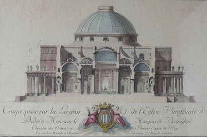
Charles Dupuis French 18th century, Pair Hand Colored Engravings, ArchitecturalGlobal Auctions Company4.3(36)See Sold PriceMar 03, 2024
LOT OF 9 ANTOINE DE MARCENAY ETCHINGS 18th C.Marnie Collection Auction4.5(70)See Sold PriceMar 10, 2024
1758 MAP PARTIE DE LA MER GLACIALE contenants La Nouvelle Zemble RUSSIA antiqueJasper524.5(9.8k)See Sold PriceFeb 27, 2024
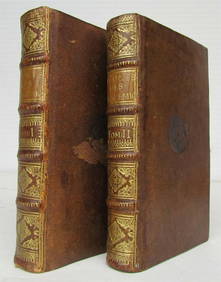
1748-1755 SERMONS by SAURIN 11 VOLUMES antique in FRENCH 18th CENTURYJasper524.5(9.8k)See Sold PriceFeb 27, 2024
1845 Delisle/Bauche Map of Martinique -- Carte de l'Isle de la Martinique Colonie Francoise de l'uneJasper524.5(9.8k)See Sold PriceFeb 27, 2024
Partie Occidentale de l’Afrique. West Africa coast Canary islands BONNE 1788 mapJasper524.5(9.8k)See Sold PriceFeb 28, 2024
1731 TWO VOLUMES ADVANCED SCIENCE IN FRENCH BY BERNARD FONTENELLENY Elizabeth 4.3(84)See Sold PriceMar 03, 2024
1757 ANTIQUE B. BELIDOR MATHEMATICS FOR ARTILLERY & ENGINEERING ILLUSTRATEDNY Elizabeth 4.3(84)See Sold PriceMar 03, 2024
ENGLISH TRANSLATION OF M.DE SECONDAT BARON DE MONTESQUIEU'S 1793 SPIRIT OF LAWS ARCHAIC LAWNY Elizabeth 4.3(84)See Sold PriceMar 03, 2024
Jean-Francois de Neufforge (1714 - 1791) - Set of 15 Architecture Prints - Plan de l' EdificeProverde Auctions4.3(3)See Sold PriceFeb 28, 2024
A Chinese carved white jade archer's ring, 18th centuryOakridge Auction Gallery4.5(190)See Sold PriceMar 15, 2024
A Chinese carved white jade archer's ring, 18th centuryOakridge Auction Gallery4.5(190)See Sold PriceMar 15, 2024
A Chinese carved white jade archer's ring, 18th centuryOakridge Auction Gallery4.5(190)See Sold PriceMar 15, 2024
A Chinese white jade archer's ring, 18th centuryOakridge Auction Gallery4.5(190)See Sold PriceMar 15, 2024
A Chinese carved white jade archer's ring, 18th centuryOakridge Auction Gallery4.5(190)See Sold PriceMar 15, 2024
A Chinese carved yellow jade 'landscape' archer's ring, 18th centuryOakridge Auction Gallery4.5(190)See Sold PriceMar 15, 2024
A Chinese carved white jade 'chilong' archer's ring, 18th centuryOakridge Auction Gallery4.5(190)See Sold PriceMar 15, 2024
A Chinese carved white jade archer's ring, 18th centuryOakridge Auction Gallery4.5(190)See Sold PriceMar 15, 2024
A Chinese carved white jade archer's ring, 18th centuryOakridge Auction Gallery4.5(190)See Sold PriceMar 15, 2024
A Chinese carved white jade 'double happiness' archer's ring, 18th centuryOakridge Auction Gallery4.5(190)See Sold PriceMar 15, 2024
A Chinese carved white jade 'beast' archer's ring, 18th centuryOakridge Auction Gallery4.5(190)See Sold PriceMar 15, 2024