SoldAntique Map : Britannia & Germania - 1860'sAntique Map : Britannia & Germania - 1860's, by Henrico Kiepert from Atlas Antiquus. Hand-Tinted. Size : 18" x 14.25"See Sold Price
Antique Map : Britannia & Germania - 1860'sAntique Map : Britannia & Germania - 1860's, by Henrico Kiepert from Atlas Antiquus. Hand-Tinted. Size : 18" x 14.25"See Sold Price
Antique Map : Britannia & Germania - 1860'sAntique Map : Britannia & Germania - 1860's, by Henrico Kiepert from Atlas Antiquus. Hand-Tinted. Size : 18" x 14.25"See Sold Price
Antique Map : Britannia & Germania - 1860'sAntique Map : Britannia & Germania - 1860's, by Henrico Kiepert from Atlas Antiquus. Hand-Tinted. Size : 18" x 14.25"See Sold Price
Antique Map : Greece - 1860'sAntique Map : Greece - 1860's by Henrico Kiepert from Atlas Antiquus. Hand-Tinted. Size : 18" x 14.25"See Sold Price
Antique Map : Greece - 1860'sAntique Map : Greece - 1860's by Henrico Kiepert from Atlas Antiquus. Hand-Tinted. Size : 18" x 14.25"See Sold Price
SoldAntique Map : Greece - 1860'sAntique Map : Greece - 1860's by Henrico Kiepert from Atlas Antiquus. Hand-Tinted. Size : 18" x 14.25"See Sold Price
Antique Map : Greece - 1860'sAntique Map : Greece - 1860's, Graecia by Henrico Kiepert from Atlas Antiquus, Hand-Tinted. Size : 14" x 18.25"See Sold Price
Antique Map : Greece - 1860'sAntique Map : Greece - 1860's, Graecia by Henrico Kiepert from Atlas Antiquus, Hand-Tinted. Size : 14" x 18.25"See Sold Price
Antique Map : Greece - 1860'sAntique Map : Greece - 1860's, Graecia by Henrico Kiepert from Atlas Antiquus, Hand-Tinted. Size : 14" x 18.25"See Sold Price
Antique Map : Greece - 1860'sAntique Map : Greece - 1860's by Henrico Kiepert from Atlas Antiquus. Hand-Tinted. Size : 18" x 14.25"See Sold Price
SoldCollection of seventeen early antique maps fromCollection of seventeen early antique maps from Britannia Depicta by Ogilby & Bowen, unframedSee Sold Price
SoldCeylon 1860 Antique Map by Blackie. Sri LankaSteel Engraved Map Published 1860, by Blackie & Son, London for "The Imperial Atlas of Modern Geography" by Walter Graham Blackie. Hand Coloured outline as issued. Paper Size: 14.5 x 10.5 inch (37 x 2See Sold Price
17TH C. ANTIQUE MAP SIEGE OF LA ROCHELLE, FRANCE, FRAMEDThomaston Place Auction Galleries4.4(386)See Sold PriceFeb 24, 2024
18TH C. ANTIQUE MAP: FRENCH & INDIAN WAR, FRAMEDThomaston Place Auction Galleries4.4(386)See Sold PriceFeb 24, 2024
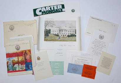
1977 INAUGURATION of PRESIDENT JIMMY CARTERJohn McInnis Auctioneers,LLC4.6(502)See Sold PriceFeb 25, 2024
Antique Britannia "Chased by Hand" Silver Plate Footed Teapot on Tilting Stand with BurnerNeo FineArts Inc4.4(12)See Sold PriceFeb 25, 2024
Framed Hand Colored Antique Map of the Department of Nord, FranceDonny Malone Auctions4.5(1.7k)See Sold PriceMar 04, 2024
Antique 1860 C. T. Bingham Late F. Fenney Tally Ho Straight Razor w/ Box.Westside Traders Emporium4.5(34)See Sold PriceFeb 27, 2024
Jesenske & Mucha's Ballady a Pisne - Ornately Bound Volume with Frontispiece illustrated by MuchaTrillium Antique Prints & Rare Books4.5(30)See Sold PriceFeb 24, 2024
1729 GERMANIA SACRA by M. Hansiz BLINDSTAMPED PIGSKIN antique FOLIO w/ MAPJasper524.5(9.8k)See Sold PriceFeb 27, 2024
Western Africa by Edward Weller. Early British/French settlements 1860 old mapJasper524.5(9.8k)See Sold PriceFeb 28, 2024
Africa. Mauritius, Bourbon (Reunion) & Natal by Edward Weller 1860 old mapJasper524.5(9.8k)See Sold PriceFeb 28, 2024
Africa inc. discoveries of Livingstone Barth Vogel Chadda Exp. SWANSTON 1860 mapJasper524.5(9.8k)See Sold PriceFeb 28, 2024
Cooke, George 1801 Antique Map. United States of AmericaAlbion Auctions4.6(336)See Sold PriceMar 01, 2024
Elias Fries (1794 - 1878) - Set of 4 Mushroom Prints - Cantarellus Aurantiacus - Merulius LacrymansProverde Auctions4.3(3)See Sold PriceFeb 28, 2024
Elias Fries (1794 - 1878) - Set of 4 Mushroom Prints - Agaricus Rubescens - Polyporus FomentariusProverde Auctions4.3(3)See Sold PriceFeb 28, 2024
Francis McNally - Antique Map of Ohio, Indiana & KentuckyProverde Auctions4.3(3)See Sold PriceFeb 28, 2024
Francis McNally - Antique Map of Washington, Oregon, Idaho, Nevada, Utah & ArizonaProverde Auctions4.3(3)See Sold PriceFeb 28, 2024
Antique Map of Poland, 1700 by Guillaume De Lisle, ParisAntiques Online Auctions4.6(407)See Sold PriceMar 14, 2024