SoldElijah H. Burritt Early American Celestial Maps,Elijah H. Burritt Early American Celestial Maps, compiled in "Atlas, Designed to Illustrate the Geography of the Heavens...", (New York: Huntington & Savage, 1835, small folio (16" x 14.25"), paper wrSee Sold Price
SoldElijah H. Burritt Early American Celestial Maps,Elijah H. Burritt Early American Celestial Maps, compiled in "Atlas, Designed to Illustrate The Geography of the Heavens...," (New York: F. J. Huntington & Co., 1835), small folio, green paper wraps wSee Sold Price
Sold(2) COPIES OF EARLY CELESTIAL ATLASES"Atlas, Designed to Illustrate the Geography of the Heavens" by Elijah H. Burritt, New York, Huntington and Savage (FJ Huntington and Co), 1835. Second and Third Editions. 14" x 16" folios, soft wrapsSee Sold Price
(2) COPIES OF EARLY CELESTIAL ATLASES"Atlas, Designed to Illustrate the Geography of the Heavens" by Elijah H. Burritt, New York, Huntington and Savage (FJ Huntington and Co), 1835. Second and Third Editions. 14" x 16" folios, soft wrapsSee Sold Price
SoldEarly Celestial Planisphere 1835 Huntington/BurritThis lot features a double page map dated 1835 titled "A Celestial Planisphere or Map of the Heavens"; engraved by W G Evans under the direction of E H Burritt; from the Atlas Designed to Illustrate TSee Sold Price
SoldSCARCE 1835 MAP OF THE HEAVENSElijah H. Burritt; "A Celestial Planisphere, or Map of the Heavens", Plate VIII, published by F.J. Huntington, engraved by W.G. Evans, 1835, Hartford, Connecticut. Along the bottom is "A Scale exhibitSee Sold Price
A CELESTIAL PLANISPHERE, OR MAP OF THE HEAVENS,Elijah H. Burritt - A Celestial Planisphere, Or Map Of The Heavens, 1835 - 40 X 28 7/8 In. - This Giclée Print Is Gallery Stretched And Ready To HangSee Sold Price
SoldElijah H. Burritt's Geography of the Heavens Folio 1856The 1856 edition with revisions and corrections done by Hiram Mattison of Elijah H. Burritt's 1835 edition. This folio of celestial maps features 6 celestial maps, two pages featuring scales of the soSee Sold Price
SoldElijah H. Burritt (American, 1794-1838) Four StarElijah H. Burritt (American, 1794-1838) Four Star Charts from 'Atlas Designed to Illustrate the Geography of the Heavens'. Engraved and published by F.J. Huntington in 1835. Including 'Northern CircumSee Sold Price
MAPS-GEOGRAPHY OF THE HEAVENS, ELIJAH H. BURRITT,GEOGRAPHY OF THE HEAVENS, ELIJAH H. BURRITT, 1835 complete with ten illustrated pages of celestial mapsSee Sold Price
SoldA CELESTIAL PLANISPHERE, OR MAP OF THE HEAVENS, 1This Is A ELIJAH H. BURRITT Giclee on Canvas Titled "A CELESTIAL PLANISPHERE, OR MAP OF THE HEAVENS, 1835" Measuring - 44 x 31 3/4 in. This Giclée is high-resolution and of the highest quality, has aSee Sold Price
SoldGroup of Early 19th Century Celestial Mapshand-colored engravings by W. G. Evans of New York, under the direction of editor E. H. Burritt. published 1835, Hartford, Connecticut by F. J. Huntington in the “Atlas of the Heavens”. the atlasSee Sold Price
SoldBURRITT, ELIJAH H. Atlas, Designed to IllustraBURRITT, ELIJAH H. Atlas, Designed to Illustrate the Geography of the Heavens . . . New Edition. [cover title]. 7 hand-colored engraved celestial maps, uncolored double-page engraved plan of the solarSee Sold Price
Sold(CELESTIAL.) Burritt, Elijah H. Group of 7 hand-colored(CELESTIAL.) Burritt, Elijah H. Group of 7 hand-colored engraved celestial charts. Folio sheets, one double-page; light foxing. – Hartford, 1835See Sold Price
SoldAtlas of Heavens. Burritt. 1835.[Celestial] Burritt, Elijah H. F.J. Atlas, Designed to Illustrate the Geography of the Heavens, Comprising the Following Maps or Plates. Huntington and Co, New York, 1835. New edition. Includes All 8See Sold Price
Sold(Maps and Charts, Celestial), Four prints taken fr(Maps and Charts, Celestial), Four prints taken from Burritt, Elijah H., (1794-1838), Atlas, Designed to Illustrate the Geography of the Heavens. New York: Huntington, 1835, folio, framed, sight 14 1/See Sold Price
SoldBurritt (Elijah H.) Geography of the HeavensCelestial.- Burritt (Elijah Hinsdale) Atlas designed to illustrate the Geography of the Heavens, vignette cover title, double-page plan of the solar system, and Celestial Planisphere or Map ofSee Sold Price
Sold"Atlas, Geography of the Heavens" & "British West Indie"Atlas, designed to illustrate the Geography of the Heavens, comprising maps and plates..." by Elijah H. Burritt, A.M. Pub. by F. J. Huntington, 1836. Stain to front cover, slight foxing to pages, verSee Sold Price
SoldHuntington 6 American celestial charts, c. 1835Huntington, F. J.- A set of 6 American celestial charts, c. 1835, engraved by W. G. Evans, New York, under the direction of E. H. Burritt, comprising plates II - VII, with various astronomical figuresSee Sold Price
Sold1835 Elijah H. Burritt AtlasDESCRIPTION: 1835 Elijah H. Burritt Atlas, Designed to Illustrate the Geography of the Heavens and containing hand colored maps. Published by Huntington and Savage, New York. MEASUREMENTS: 16-1/4" x 1See Sold Price
SoldPAIR OF HUNTINGTON AND BURRITT CELESTIAL MAPSPAIR OF HUNTINGTON AND BURRITT CELESTIAL MAPS, hand-colored engraving on paper, Plates VI and VII, Northern and Southern circumpolar maps, from Elijah Hinsdale Burritt's "Atlas, Designed to IllustrateSee Sold Price
SoldEarly-19th Century Celestial MapsGrouping of 6 celestial maps (housed in 5 frames) published by F.J. Huntington in the 1835 as part of Elijah H. Buritt's "Atlas, Designed To Illustrate The Geography Of The Heavens". Grouping includesSee Sold Price
SoldElijah H. Burritt, The Geography of the HeavensElijah H. Burritt, The Geography of the Heavens (New York: Huntington & Savage, 1848) accompanied by Atlas, Designed to Illustrate the Geography of the Heavens.Estimate: $200 - $400See Sold Price
SoldHuntington American celestial chartsHuntington, F. J.- A set of 6 American celestial charts, c. 1835, engraved by W. G. Evans, New York, under the direction of E. H. Burritt, comprising plates II - VII, with various astronomical figuresSee Sold Price
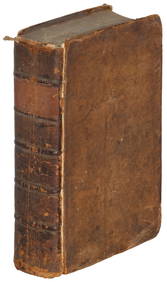
H L Ritchie (US,early 20C) oil painting antiqueBroward Auction Gallery4.8(277)See Sold PriceMar 17, 2024
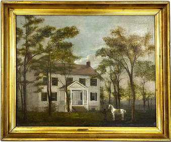
Early American Montgomery County Maryland Oil Painting on Canvas Gilt FramedChina Luban Art & Antique, Inc.4.4(78)See Sold PriceFeb 24, 2024
A H Wayne (US,early 20C) oil painting antiqueBroward Auction Gallery4.8(277)See Sold PriceMay 05, 2024
Arrowsmith & Lewis - Map of PolynesiaTrillium Antique Prints & Rare Books4.5(30)See Sold PriceFeb 24, 2024
Arrowsmith & Lewis - Map of North AmericaTrillium Antique Prints & Rare Books4.5(30)See Sold PriceFeb 24, 2024
Arrowsmith & Lewis - Map of the World on Mercator's ProjectionTrillium Antique Prints & Rare Books4.5(30)See Sold PriceFeb 24, 2024
Arrowsmith & Lewis - Map of LouisianaTrillium Antique Prints & Rare Books4.5(30)See Sold PriceFeb 24, 2024
Arrowsmith & Lewis - Map of the United StatesTrillium Antique Prints & Rare Books4.5(30)See Sold PriceFeb 24, 2024
Carey, pub. 1796 - Map of the State of MarylandTrillium Antique Prints & Rare Books4.5(30)See Sold PriceFeb 24, 2024
Carey, pub. 1796 - Map of GeorgiaTrillium Antique Prints & Rare Books4.5(30)See Sold PriceFeb 24, 2024
Carey, pub. 1796 - Map of The State of South CarolinaTrillium Antique Prints & Rare Books4.5(30)See Sold PriceFeb 24, 2024
Carey, pub. 1796 - Map of KentuckyTrillium Antique Prints & Rare Books4.5(30)See Sold PriceFeb 24, 2024
Carey, pub. 1796 - Map of the Tennassee State formerly part of North Carolina (Tennessee)Trillium Antique Prints & Rare Books4.5(30)See Sold PriceFeb 24, 2024
H D Ramsdell (US,early 20C) oil painting antiqueBroward Auction Gallery4.8(277)See Sold PriceMay 19, 2024
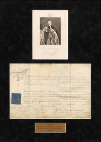
King George III (English, 1760-1820) Signed Military Commission Document, Ca. 1812, H 9" W 13.25"DuMouchelles4.6(825)See Sold PriceMar 15, 2024