SoldAntique Map of New York StateAntique map of New York State backed on linen. [42 1/2" x 49 1/2" W]. In poor condition.See Sold Price
SoldMitchell: Antique Map of New York State w/ city insetsCounty Map of the State of New York The beautifully detailed and colored county map of New York State from the 1870 edition of Mitchell's popular New General Atlas of the world. Framed by the vine motSee Sold Price
SoldRichmond: Antique Map of New York State Canals, 1858Title/Content of Map: 1858 Richmond map of the New York State Canals -- Map and Profiles of New-York State Canals Date Printed: 1858, Albany Cartographer: Van R Richmond Size: 22.8 x 39.8 in. A very iSee Sold Price
Richmond: Antique Map of New York State Canals, 1858Map: 1858 Richmond map of the New York State Canals -- Map and Profiles of New-York State Canals Date Printed: 1858, Albany Cartographer: Van R Richmond Size: 22.8 x 39.8 in. Condition: Very Good - GoSee Sold Price
Homann: Antique Map of New England, 1720The map names New England as "Almouchi Cosen" as well as Nova Anglia, while present-day New York State is named variously as New Jork, Nieuw Nederland and Novum Belgium (New York, New Netherlands andSee Sold Price
Homann: Antique Map of New England, 1720Nova Anglia'.New England Novum Belgium.Long Island Jorck Shire. The map names New England as "Almouchi Cosen" as well as Nova Anglia, while present-day New York State is named variously as New Jork, NSee Sold Price
Sold7V REVOLUTIONARY WAR IN NEW YORK STATE Antique7V REVOLUTIONARY WAR IN NEW YORK STATE Antique Decorative Gilt Leatherbound Dutchman’s Fireside James Kirke Paulding Complete Gazetteer Horatio Gates Spafford Fold‾Out Facsimile Map AnnalSee Sold Price
Williams: Antique Pocket Map on New York State, 1828Title: 1828 Williams Pocket Map on New York State -- The Tourist's Map of the State of New York Compiled from the Latest Authorities in the Surveyor General's Office Cartographer: W. Williams Year / PSee Sold Price
SoldHomann: Antique Map of New England, 1720The map names New England as "Almouchi Cosen" as well as Nova Anglia, while present-day New York State is named variously as New Jork, Nieuw Nederland and Novum Belgium (New York, New Netherlands andSee Sold Price
SoldThomas, Cowpwerthwait: Antique Map of New York, 1854Title/Content of Map: 1854 Thomas, Cowpwerthwait Map of New York State -- Map of the State of New York Compiled from the Latest Authorities Date Printed: 1854 Philadelphia Cartographer: Thomas, CowperSee Sold Price
SoldWilliams: Antique Pocket Map on New York State, 1828Map: 1828 Williams Pocket Map on New York State -- The Tourist's Map of the State of New York Compiled from the Latest Authorities in the Surveyor General's Office Cartographer: W. Williams Year / PlaSee Sold Price
SoldLot/3 Antique Maps of United States, Albany New YorkLot of three antique maps. A large hanging map of North America and Central America. United States Ornamental map with Presidents around the border. Hanging map of Albany New York by Jay Gould. All wiSee Sold Price
SoldAN ANTIQUE MAP, "United States of America," NEW YORK,AN ANTIQUE MAP, "United States of America," NEW YORK, 1827, hand colored engraving on paper, engraved by Benjamin Tanner (1775-1848). 17" X 21 5/8" Note: This map unusually shows two locations for GalSee Sold Price
SoldMap of the State of New York by J. DenisonCirca 1796 Antique Map, Title: Map of the State of New York by J. Denison. A. Doolittle (sculp.) Approximate size: 10-5/8" x 8-3/8". Please note that this lot has a confidential reserve. When you leavSee Sold Price
SoldAntique Hand Colored Engraved Map NEW YORK STATE SmithDetails: This nicely hand-colored engraved map of New York State was designed by J. Calvin Smith and published by J. Disturnell circa 1852. Featuring insets of New York City and the St. Lawrence RiveSee Sold Price
SoldANTQ RAND MCNALLY NEW YORK STATE CITY MAPS c1895 XRWe are pleased to offer this large lot of Rand McNally New York Maps c. 1895. These are original Antique Color Lithograph Engraved Maps. There is a City Map of the Southern portion of New York City, aSee Sold Price
Sold6V COLLECTIBLE ANTIQUE NEW YORK STATE HISTORY6V COLLECTIBLE ANTIQUE NEW YORK STATE HISTORY Decorative Gilt Buffalo Scrapbook Octavius Orlando Cottle Leatherbound Onondaga County Centennial Syracuse Maps Tables Portraits Onondaga Reservation LakeSee Sold Price
SoldA CIVIL WAR ERA ANTIQUE MAP, "Johnson's New Map of theA CIVIL WAR ERA ANTIQUE MAP, "Johnson's New Map of the State Of Texas," NEW YORK, 1860-1863, hand colored engraving on paper, page fragments from an atlas, plates no. 43-44, with inset plans of "SabinSee Sold Price
SoldAntique Wall Map NEW YORK POSTAL ROUTES 1898 MailDetails: This large hanging wall map of postal routes in the state of New York was created by topographer A. von Haake, and printed by "Julius Bien & Co., Photo. Lith." Dated March, 1, 1898, this mapSee Sold Price
SoldAN AMERICAN CIVIL WAR ERA ANTIQUE MAP, "Johnson's NewAN AMERICAN CIVIL WAR ERA ANTIQUE MAP, "Johnson's New Map of the State Of Texas," NEW YORK, 1860-1863, hand colored engraving on paper, by "Johnson & Browning" with "Plan of Sabine Lake," "Plan of GalSee Sold Price
SoldDistrunell: Antique Township Map of New York, 1855Map: 1855 Distrunell Township Map of New York -- Map of the State of New York Showing the Boundaries of Counties & Townships, the Location of Cities, Towns and Villages: and the Courses of Rail Roads,See Sold Price
SDUK: Antique Map of United States East Coast, 1844Title/Content of Map: 'NORTH AMERICA, SHEET VI., New York, Vermont, Maine, New Hampshire, Massachusetts, Connecticut, Rhode Island, New Jersey' Date Printed: This map was originally published by BaldwSee Sold Price
Tanner: Antique Map of United States, 1843Title/Content of Map: United States by Tanner Date Printed: 1843 Cartographer: Tanner Material/Medium: Paper Size: 14" x 17" Provenance: New York Published in Philadelphia Please note that this lot haSee Sold Price
SoldAntique Middle States Map - 1872Antique Middle States Map - 1872, featuring Maryland, Virginia, West Virginia, Pennsylvania, New York & New Jersey. Size : 9" x 10.75"See Sold Price
1892 Adams and Bowles New Road Map of the State of New YorkJM Hobby Supply and Railroad Artifact Auctions4.4(126)See Sold PriceFeb 24, 2024
Crams Railroad Map of New York-1881JM Hobby Supply and Railroad Artifact Auctions4.4(126)See Sold PriceFeb 24, 2024
1964 R.F.K. for US SENATE CAMPAIGN MATERIALSJohn McInnis Auctioneers,LLC4.6(502)See Sold PriceFeb 25, 2024
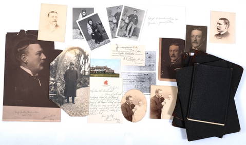
HUGH D. AUCHINCLOSS I (1858-1913) IN MEMORIAMJohn McInnis Auctioneers,LLC4.6(502)See Sold PriceFeb 25, 2024
Vintage County Map Of NY State Plate EngravingThe Benefit Shop Foundation Inc.4.3(2.9k)See Sold PriceFeb 28, 2024
ANDREW RAYMOND JANSON OIL ON BOARD ADIRONDACKSCharleston Estate Services Ltd.4.5(58)See Sold PriceMar 03, 2024
Audubon - 8 Quadruped LithographsTrillium Antique Prints & Rare Books4.5(30)See Sold PriceFeb 24, 2024
Audubon, Amsterdam Ed - Yellow-breasted Chat. 137Trillium Antique Prints & Rare Books4.5(30)See Sold PriceFeb 24, 2024
Audubon, Amsterdam Ed - Meadow Lark. 136Trillium Antique Prints & Rare Books4.5(30)See Sold PriceFeb 24, 2024
Audubon, Amsterdam Ed - American Robin. 131Trillium Antique Prints & Rare Books4.5(30)See Sold PriceFeb 24, 2024
Audubon, NYSE Best Watercolor Ed - Pair: Brown Pelican & Reddish EgretTrillium Antique Prints & Rare Books4.5(30)See Sold PriceFeb 24, 2024
3 - 19THC. NEW YORK STATE BASKETS, 2 SWING HANDLE LARGEST IS 18" DIAMCarlsen Gallery, Inc.4.6(163)See Sold PriceMar 03, 2024
2 - 19THC. NEW YORK STATE SWING HANDLE BASKETS LARGEST 15 1/2' WIDECarlsen Gallery, Inc.4.6(163)See Sold PriceMar 03, 2024
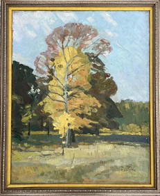
Paul Strisik (Attributed) Oil on Canvas Art: 19.6" x 15.5"Carstens Galleries4.5(128)See Sold PriceMar 01, 2024
1901 Alfred University New York State School Ceramic Mother of Pearl Sheen VaseMatthew Bullock Auctioneers4.7(1.8k)See Sold PriceMar 02, 2024