MAP - PIETER SCHENK / VALK / JANSSEN Hand Colored superb Map Central Italy c1702Luis Porretta Fine Arts4.3(10)See Sold PriceMar 02, 2024
CHARLES ROLLIN c1828 Ceasar Hand Colored Africa Military MapLuis Porretta Fine Arts4.3(10)See Sold PriceMar 02, 2024
MAP - Dufour, A. H. ( Malte / Brun ) :MAP - ESPAGNE PARTIE SUD DIVISEE EN PROVINCES ANCIENNES ( MAPLuis Porretta Fine Arts4.3(10)See Sold PriceMar 02, 2024
RIGOBERT BONNE c1787 Original Colored Map Germany & Region 15" x 12"Luis Porretta Fine Arts4.3(10)See Sold PriceMar 02, 2024
AMBROISE TARDIEU c1822 Napoleonic War Map GermanyLuis Porretta Fine Arts4.3(10)See Sold PriceMar 02, 2024
MAP - AMBROISE TARDIEU c1822 Napoleonic Miltary Map GermanyLuis Porretta Fine Arts4.3(10)See Sold PriceMar 02, 2024
1822 Rare Map by Ambroise Tardieu Napoleon Caldiero Battle of Vento 17" x 11Luis Porretta Fine Arts4.3(10)See Sold PriceMar 02, 2024
PIETER SCHENK / VALK / JANSSEN Hand Colored Map of Rhodes Greece ca1702 vgcLuis Porretta Fine Arts4.3(10)See Sold PriceMar 02, 2024
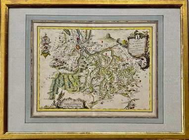
Map: Carte du Canton de Bale, Jacques Clermont, Paris, 1788Kensington Estate Auction4.6(219)See Sold PriceFeb 26, 2024
A handsome French edition of the Popple key mapAmerique Septentrionale Suivant la Carte du Pople faite à Londres en 20 feuilles. Henry Popple (d.1743). Copper-engraved map with period hand colouring in full. Paris: Par et chez le Sr. le Rouge, 17See Sold Price
SoldProbst, Johann Michael 1782Probst, Johann Michael, "Nova Mappa Geographica Americae Septentrionalis", Augsberg, 1782, hand-colored, based on the Le Rouge edition of Henry Popple's key map of 1733, insets show New York, Boston,See Sold Price
SoldKey map of Popple's British North AmericaHeading: Author: Popple, Henry Title: A Map of the British Empire In America with the French, Spanish and the Dutch Settlements adjacent thereto by Henry Popple Place Published: Amsterdam Publisher:ISee Sold Price
SoldPOPPLE, HENRY. A Map of the British Empire inPOPPLE, HENRY. A Map of the British Empire in America with the French and Spanish Settlements adjacent thereto. 20-sheet map in uncolored state, plus key map in full contemporary color. Key map measurSee Sold Price
1746 Popple Key Map of North America (Crepy)Item: 1746 Popple Key Map of North America (Crepy) Description: Popple Key Map of North America (Crepy) Dimensions: 20.25 x 19.5 in Please note that this lot has a confidential reserve. When you leaveSee Sold Price
SoldAbraham Ortelius 16th Cent. ''Typus Orbis Terrarum''Abraham Ortelius 16th Cent. ''Typus Orbis Terrarum'' World Map Engraving 22.5''x28.5'' Framed. A scarce hand tinted ''World from Theatre Du Monde'' 1587 French edition map. Purchased at Mapsellers LimSee Sold Price
SoldEgypt.- Ebers (Georges) L'Égypte, du Caire a Philae,Egypt.- Ebers (Georges) L'Égypte, du Caire a Philae, vol. 2 only, of 2, first French edition, colour map, illustrations, many full-page, gift inscription on fly-leaf, some spotting, original red moSee Sold Price
Egypt.- Ebers (Georges) L'Égypte, du Caire a Philae,Egypt.- Ebers (Georges) L'Égypte, du Caire a Philae, vol. 2 only, of 2, first French edition, colour map, illustrations, many full-page, gift inscription on fly-leaf, some spotting, original red morSee Sold Price
Handsome old color French Map of Africa by ValkL'Afrique divisee suivant l'estendue de ses principales parties... Gerard Valk (1652 - 1726). Engraved map with handcolor in part. Amsterdam, c.1700. 20 1/4 x 23 3/4 inches sheet, 30 1/2 x 34 inches fSee Sold Price
SoldOrtelius (Abraham) Theatre de l'UniversOrtelius (Abraham) Theatre de l'Univers, contenant les cartes de tout le monde,engraved pictorial title, portrait and 121 map plates on 119 double-page sheets, French text edition, but map ofSee Sold Price
Legge (W.V.) the birds of CeylonLegge (W.V.) A History of the Birds of Ceylon, first edition, key plate, coloured, map, 34 hand-coloured plates by Keulemans, minor worming in first few leaves, title loose, some browning, fewSee Sold Price
SoldBain (James, F.R.G.S.) - The Authentic Map Directory offourth edition, the last pre-war edition, complete with key map, large-scale street plan of London and suburbs in 173 sections, a plan of the City in 3 sections, with additional maps of parliamentary,See Sold Price
Amerique Du Nord Par A.H. Dufour.Reserve Reduced! Title: Amerique Du Nord Par A.H. Dufour. Publication Date: 1859 Cartographer: Dufour, A H Publisher: J. Andriveau-Goujon Size: 35.5 x 25.6 Handsome very large French map from the periSee Sold Price
SoldHansteen (Christopher) - Souvenirs d'un Voyage enfirst French edition , engraved folding map, contemporary roan backed marbled boards, gilt, Paris , 1857 § Palmer (Aaron H.) Memoir, Geographical, Political and Commercial....of Siberia, ManchuriSee Sold Price
Sold-. Ferrier (J.-P.) Voyages en Perse dans l'Afghan-. Ferrier (J.-P.) Voyages en Perse dans l'Afghanistan, le Bélouchistan et le Turkestan,2 vol., first French edition, frontispiece, folding map, original printed wrappers, uncut, old ink stamSee Sold Price
SoldAfrica.- Ludolf (Hiob) Nouvelle Histoire d'Abissinie,Africa.- Ludolf (Hiob) Nouvelle Histoire d'Abissinie, ou d'Ethiopie, first French edition, folding engraved map and 5 plates, privilege leaf at end, author's name stamped at foot of title, slight wormSee Sold Price
SoldLondon.- Bain (James, F.R.G.S.) The Authentic MapBain (James, F.R.G.S.) The Authentic Map Directory of London and Suburbs, Fourth edition, the last pre-war edition, complete with key map, large-scale street plan of London and suburbs in 173 sectionsSee Sold Price
Amerique Du Nord Par A.H. Dufour.Title/Content of Map: Amerique Du Nord Par A.H. Dufour. Date Printed: 1859 Cartographer: Dufour, A H Size: 35.5X25.6 Handsome very large French map from the period of Emperor Napoleon III. From the AtSee Sold Price
SoldSolis y Ribadeneyra (Antonio de) Histoire de la CoSolis y Ribadeneyra (Antonio de) Histoire de la Conquête de Mexique ou de la Nouvelle Espagne,first French edition, 12 engraved maps & plates only (of 14), 9 folding, lacking errata leaf aSee Sold Price
SoldPrzhevalskii. Mongolie et Pays des TangoutesPrzhevalskii (Nikolai M.) Mongolie et Pays des Tangoutes,first French edition, 4 folding maps, wood-engraved plates and illustrations, maps a little browned, occasional light foxing, slight waSee Sold Price
SoldFrench edition of Mitchell's seminal map of NorthHeading: Author: Mitchell, John / George Louis Le Rouge Title: Amerique Septentrionale avec les Routes, Distances en miles, Villages et Etablissements François et Anglois Par le Docteur Mitchel TradSee Sold Price
SoldProbsts Key Map After PoppleNova Mappa Geographica Americae Septentrionalis. Johann Michael Probst. Engraving with hand color in full. 1792. 27 1/4 x 21 1/2 inches sheet. This is a variant of the key map of Henry Popple's seminaSee Sold Price
SoldAsia.- Férrier (Jean-Paul) Voyages en Perse, dandAsia.- Férrier (Jean-Paul) Voyages en Perse, dand l'Afghanistan, le Béloutchistan et le Turkestan,2 vol., first French edition, portrait frontispiece, folding map, printed wrappers, vol. 1 spSee Sold Price
Sold2 BOOKS "VOYAGE IN AMERICA" "DISCOVERING AMERICA"2 BOOKS "VOYAGE IN AMERICA" FRENCH EDITION & "DISCOVERING AMERICA" WITH MAP (GERMAN 1825 BY JOACHEM WEINRICH CAMPE W/11" PULL OUT MAP & FRENCH BOOK 1889 ATALA RENE LES ABENICERAGES)See Sold Price
M. de BOILEAU Satires & Works First 1st 1737 Edition Amsterdam Printing FrenchLuis Porretta Fine Arts4.3(10)See Sold PriceMar 02, 2024
Catesby, Folio - Tumble-Turds (Dung Beetle) with Canada Lily. Sup-11Trillium Antique Prints & Rare Books4.5(32)See Sold PriceFeb 24, 2024
Catesby, Folio - American Goldfinch with Acacia. 1-43Trillium Antique Prints & Rare Books4.5(32)See Sold PriceFeb 24, 2024
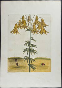
Catesby, Folio - Bahama Titmouse with Seven Years Apple. 1-59Trillium Antique Prints & Rare Books4.5(32)See Sold PriceFeb 24, 2024
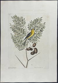
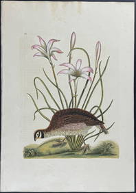
Catesby, Folio - American Partridge with Attamusco Lily. Sup-12Trillium Antique Prints & Rare Books4.5(32)See Sold PriceFeb 24, 2024
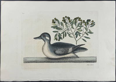
Catesby, Folio - Little Brown Duck with Soap-Wood. 1-98Trillium Antique Prints & Rare Books4.5(32)See Sold PriceFeb 24, 2024
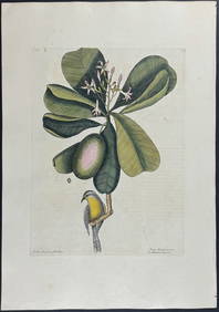
Catesby, Folio - Red Bellied Woodpecker & Hairy Woodpecker with Black Oak. 1-19Trillium Antique Prints & Rare Books4.5(32)See Sold PriceFeb 24, 2024
Jules Verne, Mirifiques Aventures de Maitre, Aux HarponsLion and Unicorn4.8(1.9k)See Sold PriceMar 03, 2024
Jules Verne, Le Testament d'un Excentrique, Aux HarponsLion and Unicorn4.8(1.9k)See Sold PriceMar 03, 2024
Jules Verne, Mirifiques Aventures de Maitre, Aux HarponsLion and Unicorn4.8(1.9k)See Sold PriceMar 03, 2024
Jules Verne, P'tit Bonhomme, Aux Harpons, Red CoverLion and Unicorn4.8(1.9k)See Sold PriceMar 03, 2024
1792 OLD INDIA HISTORY ANTIQUE ILLUSTRATED WITH MAPS OF THE EIGHTEENTH CENTURY IN FRENCHNY Elizabeth 4.2(86)See Sold PriceMar 03, 2024
James Cook - Map of the Friendly Isles - Tonga IslandsProverde Auctions4.3(3)See Sold PriceFeb 28, 2024
Jules Verne, De La Terre a La Lune, Au Steamer Red MacaronLion and Unicorn4.8(1.9k)See Sold PriceMar 10, 2024
Jules Verne, L'Archipel en Feu, Au Steamer Red MacaronLion and Unicorn4.8(1.9k)See Sold PriceMar 10, 2024
Jules Verne, L'Etoile du Sud, Au Steamer Red MacaronLion and Unicorn4.8(1.9k)See Sold PriceMar 10, 2024