SoldTwo Lithograph Maps of BrooklineLot of two lithograph maps of Brookline, Massachusetts, plates A and B circa 1888, published G. W. Bromley, 20" h x 29 1/2" w.See Sold Price
SoldTwo Florida Lithograph MapsMap of Florida. 2 Lithographed maps. Phildelphia: Thomas Cowperthwait & Co., 1850 (right). Unknown (left). 20 1/4 x 17 1/4 inches framed (right). 27 x 24 inches framed (left)See Sold Price
SoldGROUPING OF MAPS(3) pieces including contemporary map of New England in gold frame, and two French lithograph maps. Dimensions: (Largest) (Frame) H 24.5" x W 18.5" Condition: Crack to glass of largest. No issues to oSee Sold Price
SoldBartholomew, John 1889 Lot of 6 Climate etc MapsIncl Rainfall/Winds, January/July Isotherms, Range of Temperature, Mineral Products, Vegetable Products (Two versions) Lithograph Maps Published 1889, Cambridge for "Atlas of Commercial Geography" bySee Sold Price
Bartholomew, John 1889 Lot of 6 Climate etc MapsIncl Rainfall/Winds, January/July Isotherms, Range of Temperature, Mineral Products, Vegetable Products (Two versions) Lithograph Maps Published 1889, Cambridge for "Atlas of Commercial Geography" bySee Sold Price
SoldLineol painted composition command soldiersLineol painted composition command soldiers, sixteen pieces, to include two tin lithograph map tables, tallest - 3 1/4''.See Sold Price
Sold18TH CENTURY MAPS OF ITALY & MOLDOVIATwo antique hand-colored lithograph maps. The first reads, "Terra d'Otranto Tratta dalla Carte del Sigr. Rizzi Zannoni, Venezia, 1783, Presso Antonio Zatta con Privilegio dell' Eccmo Senato." The secoSee Sold Price
Sold18TH CENTURY MAPS OF SICILY & VENICE, ITALYTwo antique hand-colored lithograph maps. The first reads, "Italia Antiqua cum Insulis Sicilia, Sardinia, et Corscia in suas marjores partes et populor divisa, Venetiis, 1785, Apud Antonium Zatta et FSee Sold Price
Sold18TH CENTURY MAP OF VENEZIA, ITALYTwo antique hand-colored lithograph maps. The first reads, "Parte del Piemonte, che contione il Distretto il Torino, il Contado d'Asti ... Tratta dalla Carta dell'Ingegnere Borgonio, Venezia, 1782, PrSee Sold Price
SoldThree Civil War Books and Two Natick, MassachusettThree Civil War Books and Two Natick, Massachusetts Lithograph Hanging Maps, Campfire and Battlefield, Bryan, Taylor & Co., 1894, New York; The Soldier in our Civil War, vol. I and II, G.W. Carleton &See Sold Price
SoldTWO 18TH CENTURY MAPS OF GERMANYTwo antique hand-colored lithograph maps. The first reads, "Palatinatus Inferior, sive Electroratus Palatinus ad Rhenum ... Cura et Studio Tobae Conradt Lotter, Geographi et Chalcographi Augustani" (sSee Sold Price
SoldRussian School 20th century, Three lithographs: map andRussian School 20th centuryThree lithographs: map and two scenes depicting Russia at war with the Ottoman EmpireWith Cyrillic script, the two war scenes printed in Moscow; the map backed on canvas; alSee Sold Price
Sold[Two Maps of Charleston] 1877 & 1880[Two Antique Maps of Charleston], lithograph maps, both published by Walker, Evans & Cogswell, Charleston, SC; "Map of Charleston, South Carolina, Revised 1877", with an index of public buildings; andSee Sold Price
(2) 19th C. Handcolored Litho Maps of CanadaTwo (2) 19th Century handcolored lithograph maps, including: Johnson's "Upper Canada, Lower Canada, and New Brunswick", circa 1865, 26 1/2" x 18", some toning; "Provinces of Ontario and Quebec, DominiSee Sold Price
Sold(2) Lithographs of the Town of BrooklineTwo Town of Brookline, lithographs, plates A and B circa 1888, 20"h. x 29 1/2"w. unframed, publisher G.W. Bromley and Co. Some toning.See Sold Price
(2) Lithographs of the Town of BrooklineTwo Town of Brookline, lithographs, plates A and B circa 1888, 20"h. x 29 1/2"w. unframed, publisher G.W. Bromley and Co. Some toning.See Sold Price
(2) Lithographs of the Town of BrooklineTwo Town of Brookline, lithographs, plates A and B circa 1888, 20"h. x 29 1/2"w. unframed, publisher G.W. Bromley and Co. Some toning.See Sold Price
SoldChicago's Gangland Prepared by Frederic M. ThrasherTrasher, Frederic M. Chicago’s Gangland Prepared by Frederic M. Thrasher 1923-26. Chicago: The University of Chicago Press, 1926. Offset lithograph thematic map printed in two colors documentingSee Sold Price
SoldSeven Bruce Johnson LithographsBruce Johnson (Pennsylvania, 1944-). Seven pencil signed unframed lithographs to include two maps on Pennsylvania, two copies of No Maintenance - Everlasting Beauty, Skiers, My Tree House, and CampingSee Sold Price
SoldManley Hopkins Hawaii 1862Title: Hawaii: The Past, Present, and Future of Its Island Kingdom Author: Hopkins, Manley Description: xxiv, 423 pp. Two lithograph portraits; woodcut plates and vignettes; folding map. (8vo) originaSee Sold Price
SoldDisneyland "45 Years of Magic" Signed Map Fine ADisneyland "45 Years of Magic" Signed Map Fine Art Lithographs Group of Two (Walt Disney, c. 2000). On July 17th, 2000, the world's first Theme Park celebrated its 45th birthday. In the years since itSee Sold Price
Sold2pc Iowa ANTIQUE HAND-COLORED LITHOGRAPH MAPS RailroadDetails: This lot consists of the antique hand-colored lithograph maps shown in the corresponding image(s).This lot includes two identical folding pocket maps of Iowa. Both are titled "Henn. WilliamsSee Sold Price
SoldFive Lithograph Maps of the Lower MississippiFive U.S. Army Corps of Engineers Colored Lithograph Maps of the Lower Mississippi including two 1890s examples that chart the river improvements and levee lines from Lake Providence in Louisiana to tSee Sold Price
Sold4pc Midwestern America ANTIQUE LITHOGRAPH MAPSDetails: This lot consists of the antique lithograph folding pocket maps shown in the corresponding image(s).This lot includes four maps of various areas of the Midwest. There are two Rand McNally maSee Sold Price
DAVID ROBERTS - Holy Land / Syria / Egypt etc. 3 x Folio Volumes 1849 Very RareLuis Porretta Fine Arts4.3(10)See Sold PriceMar 02, 2024
WILLIAM HEATH Rare Political Cartoon Siamese Youths c1829 LithographLuis Porretta Fine Arts4.3(10)See Sold PriceMar 02, 2024
FRANCIS CALCRAFT TURNER Bachelors Hall Plate 3 ca1835 Original Colored LithoLuis Porretta Fine Arts4.3(10)See Sold PriceMar 02, 2024
[CUPS & BALLS]. Two lithographs from “La Caricature.” Frenc...Potter & Potter Auctions4.6(545)See Sold PriceFeb 24, 2024
[LITHOGRAPHY]. KELLOGG, E. C., Lithographer. Group of Two L...Potter & Potter Auctions4.6(545)See Sold PriceMar 07, 2024
William Simpson's Sketches at the Seat of War - Two Volumes with 81 Hand-colored LithographsTrillium Antique Prints & Rare Books4.5(32)See Sold PriceFeb 24, 2024
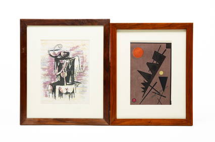
ELLSWORTH KELLY (1923-2015) AND ALEXANDER CALDER (1898-1976) TWO LITHOGRAPHS.Amelia Jeffers, Auctioneers & Appraisers4.5(120)See Sold PriceMar 09, 2024
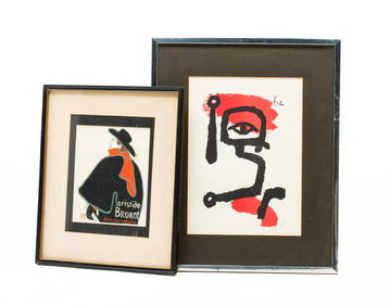
AFTER TOULOUSE LAUTREC (1864-1901) AND AFTER PAUL KLEE (1879-1940) TWO LITHOGRAPHS.Amelia Jeffers, Auctioneers & Appraisers4.5(120)See Sold PriceMar 09, 2024
After Urrabietta, Late 19th century, Lithographs, Two lithographs with examples of RussianClaydon Auctioneers Ltd4.3(125)See Sold PriceFeb 26, 2024
Derriere le Miroir 182. Chagall. With two Lithographs in colorTheRedFinch Auctions4.4(24)See Sold PriceFeb 29, 2024
TWO LITHOGRAPHS BY JEAN-CLAUDE PICOT W CERTIFICATEAntique Arena Inc.4.5(878)See Sold PriceMar 02, 2024
Two Hand-Colored 19th Century Maps of New Orleans and Louisiana, Larger- H.- 12 1/2 in., W.- 15 1/2Crescent City Auction Gallery4.3(231)See Sold PriceMar 08, 2024
Blackie (Pub) 1882 Folio Map. World on Mercators ProjectionAlbion Auctions4.6(341)See Sold PriceMar 01, 2024
Stanford, Edward 1901 Large Map. Geological Map of the British IslesAlbion Auctions4.6(341)See Sold PriceMar 01, 2024
Perry, Matthew C. 1856 Large Map. Shah Bay, Lew Chew I. JapanAlbion Auctions4.6(341)See Sold PriceMar 01, 2024
ANTIQUE ILLUSTRATED HANDBOOK OF GEOGRAPHY AND TRAVEL IN ASIA, VOLUME 2, 1896NY Elizabeth 4.2(86)See Sold PriceMar 03, 2024
Nancy Graves (American, 1939-1995) Lithograph in Colors on Arches Paper 1972, "Lunar Landscape V", HDuMouchelles4.6(830)See Sold PriceMar 15, 2024


![[Two Maps of Charleston] 1877 & 1880 (1 of 2)](https://p1.liveauctioneers.com/268/66576/33774410_1_x.jpg?height=282&quality=70&version=1421356640)


![[CUPS & BALLS]. Two lithographs from “La Caricature.” Frenc... (1 of 2)](https://p1.liveauctioneers.com/928/317913/170625949_1_x.jpg?height=282&quality=70&version=1706650066)
![[LITHOGRAPHY]. KELLOGG, E. C., Lithographer. Group of Two L... (1 of 2)](https://p1.liveauctioneers.com/928/318880/171361111_1_x.jpg?height=282&quality=70&version=1707501302)