SoldGöbl, Robert. OSTKELTISCHER TYPEN-ATLAS. Braunsch.Göbl, Robert. OSTKELTISCHER TYPEN-ATLAS. Braunsch. 1973. 4to, 43 pp., 52 plates, d.j. ex libris label JLM.See Sold Price
SoldGöbl, Robert. OSTKELTISCHER TYPEN-ATLAS. Braunsch.Göbl, Robert. OSTKELTISCHER TYPEN-ATLAS. Braunsch. 1973. 4to, 43 pp., 52 plates, d.j.; Also included, L.V. Garriga, LAS MONEDAS DE ARSE-SAGVNTVM, 1967, Barcelona, 179 pp. 10 plates, card cover.See Sold Price
SoldAppleton's Complete World Atlas 56 Hand Colored MapsMudie, Robert, Appleton's Complete Atlas of The World…. c.1850s, D. Appleton, hardcover, folio (13.5 x 11 inches), contemporary 1/2 leather, gilt title, aeg, with 56 hand-colored maps as called forSee Sold Price
SoldDIDIER ROBERT DE VAUGONDY (FRENCH, 1688-1766) ATLASDIDIER ROBERT DE VAUGONDY (FRENCH, 1688-1766) ATLAS VOLUME "Atlas Universel", 1757, folio, leather boards, engraved title page, 106 hand-colored double-page maps, missing numbers 24 and 40. With proteSee Sold Price
SoldCelestial Maps & Prints 1892 Lot of 20 by BallLithographs Published 1892, London for "An Atlas of Astronomy" by Robert Stawell Ball. Paper Size: 8 x 7 inch (21 x 18cm) Good ConditionSee Sold Price
SoldMap of Italian PeninsulaTitle: L'Italie et ses Isles circonvoisines Sicile, Sardaigne, Corse Map of Italian peninsula as well as Sicily, Sardinia and Corsica Maker: Robert de Vaugondy Origin: Paris, 1748 For Atlas Portatif USee Sold Price
SoldRobert Mills 1825 Map Kershaw District of SCThe map from the Mills Atlas 1825 edition. Having good color and well defined plate lines. Good overall condition. Sight size: H19" W23" (without frame) Sold from the private collection of a SouthernSee Sold Price
Sold(ATLAS) DELISLE, GUILLAUME. A bound collection of 28(ATLAS) DELISLE, GUILLAUME A bound collection of 28 engraved maps, hand-colored in outline, largely after Delisle (Paris, 1745), but with examples by Nicholas Sanson and Robert de Vaugondy as well. FoSee Sold Price
SoldA Clinical Atlas of Venereal & Skin Diseases Book 1889This large book is titled; A Clinical Atlas of Venereal & Skin Diseases including Diagnosis, Prognosis & Treatment by Robert W. Taylor, A.M., M.D. Philadelphia Lea Brothers & Co. 1889. Book is illustrSee Sold Price
Sold1749 Robert de Vaugondy Map of Great Lakes Region --Title/Content of Map: 1749 Robert de Vaugondy Map of Great Lakes Region -- Les Lacs du Canada et Nouvelle Angleterre Date: 1749, Paris Cartographer: G Robert de Vaugondy Size: 6.5 X 8,5 in. This is anSee Sold Price
SoldMap of England by Robert Morden 1695England by Robert Morden, Map maker : MORDEN, Robert., Date : London, 1695. Size : 14.4 x 16.7 inches. / 36.5 x 42.5 cm., Coloured later, Description :The ornate title cartouche is inscribed with ‘ESee Sold Price
SoldAntique map, Northeast US, by Robert De VaugondyAntique map, Northeast US, by Robert De Vaugondy "Partie De L'Amerique Septentrionale Qui Comprend Le Cours De L'Ohio, La Nlle Angleterre, La Nlle York, Le New Jersey, La Pensyvanie, Le Maryland La ViSee Sold Price
Sold(2) WWII BOOKS - MEMPHIS BELLE - ROBERT MORAN SIGNED(1) Col. Morgan, Robert (USAFR, Ret.); with Ron Powers; "The Man Who Flew the Memphis Belle - Memoir of a WWII Bomber Pilot"; Dutton, 2001, first printing; retains dust jacket [388 pgs]; signed on labSee Sold Price
Sold[McMURTRY, Larry (1936-2021), his copy]. GRAVES, Robert (18...[McMURTRY, Larry (1936-2021), his copy]. GRAVES, Robert (1895-1985). Goodbye to a River. [Austin: W. Thomas Taylor for] The Book Club of California, 1989. 4to. Illustrated with foldout map and from phSee Sold Price
SoldFramed Antique Map Orbis Vetus, Robert De VaugondyItem/Description: Old print. Map of the world by Robert de Vaugondy from 1752. Orbis vetus in utraque continente : In both the old continent / world map / Vaugondy 1752. Material: Print framed under gSee Sold Price
SoldGilles Robert de Vaugondy (1688-1766), "Orbis Vetus inGilles Robert de Vaugondy (1688-1766), "Orbis Vetus in Utraque Continente Juxta Mentem Sansoniam·distinctus, Redactus," 1752, Hemisphere map, hand colored, H.- 20 in., W.- 30 in.See Sold Price
Sayer: Antique Map of North British Colonies in AmericaMap: A General Map of the Northern British Colonies in America Date Printed: 1776 Cartographer: Sayer, Robert and Bennett, John Size: 26 x 20 Condition: Fair. Lined for strength with a full sheet of JSee Sold Price
SoldMorden: Antique Map of Florida & the Great Lakes, 16931693 map of Florida and the Great Lakes by Robert Morden. 5 x 5 inches. A very special map--one of the very earliest obtainable English maps of the American colonies. A Map of Florida and Ye Great LakSee Sold Price
Jefferys/Sayer: Map of Cuba, Cayman Islands, 1775Title: The Island of Cuba with part of the Bahama Banks and the Martrys Map maker: Thomas Jefferys / Robert Sayer, John Bennett Place and Year: London, 1775 Dimensions: 53 x 73 cm (21 x 29 in) TechniqSee Sold Price
de Vaugondy: Antique Map of the Americas, 1771Title/Content of Map: Amerique ou Indes Occidentales Cartographer: Robert de Vaugondy Place & Date: Paris / 1771 Size: 25" x 20" Condition: outline color; light overall age toning; minor staining alonSee Sold Price
SoldNew England Trolley Travel Guide with Maps, 1904Derrah's Trolley Trips: with Historic Houses and Picturesque Scenery or By Trolley Through Eastern New England and By Trolley Through Western New England Complied by Robert K. Derrah Robert K. DerrahSee Sold Price
Fine Antique Speculative Map of North AmericaTitle/Content of Map: Fine Antique Speculative Map of North America Date Printed: 1778 Cartographer: Vaugondy, Robert de Size (in): 11 x 9 Fine example of Robert de Vaugondy's 1778 map of North AmericSee Sold Price
Morden: Map of Florida & Ye Great Lakes of Canada, 1693Map: A Map of Florida and Ye Great Lakes of Canada Cartographer: Robert Morden Publisher: Robert Morden Date: 1693 Size: 5 x 5 inches One of the earliest obtainable English maps of the American coloniSee Sold Price
SoldMorden, Map of France, c.1690An original map of France published by Robert Morden c. 1690 with English text. Many place names, rivers and political boundaries are shown. Hand colored. Size: 4.5 x 5" (map); 7 x 5" (map and text) PSee Sold Price
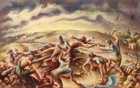
LARGE Robert Waltsak (NJ,b 1944) oil paintingBroward Auction Gallery4.8(277)See Sold PriceMar 10, 2024
LARGE Robert Waltsak (NJ,b 1944) oil paintingBroward Auction Gallery4.8(277)See Sold PriceMar 10, 2024
Robert William Wood (1889 - 1979) Texas BluebonnetsPremier Auction Galleries4.3(329)See Sold PriceMar 09, 2024
American Patrick Henry Davenport 1803-1890 Portrait Of John Robert Allen Oil On CanvasRbfinearts4.4(571)See Sold PriceFeb 24, 2024
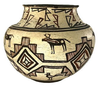
9" D. x 7" H. Pueblo Polychrome Olla Pot. Ex Robert Hand and Nick GatsesTony Putty Artifacts4.7(404)See Sold PriceMar 09, 2024
[BLACK PANTHER PARTY]. An Attack Against One Is An Attack Against All. San Francisco, CA: RobertFreeman's | Hindman4.4(1.6k)See Sold PriceFeb 27, 2024
Robert H Labberton - Map of The Territory of the Present United States - The territory of theProverde Auctions4.3(3)See Sold PriceFeb 28, 2024
CARSWELL, ROBERT. 1793-1857. Pathological Anatomy. Illustrations of the Elementary Forms of Dise...Bonhams4.1(305)See Sold PriceJun 18, 2024


![[McMURTRY, Larry (1936-2021), his copy]. GRAVES, Robert (18... (1 of 4)](https://p1.liveauctioneers.com/928/295567/157314291_1_x.jpg?height=282&quality=70&version=1689365279)


![[BLACK PANTHER PARTY]. An Attack Against One Is An Attack Against All. San Francisco, CA: Robert (1 of 1)](https://p1.liveauctioneers.com/197/319238/171467895_1_x.jpg?height=282&quality=70&version=1707520367)


