SoldCity of New Orleans Aerial View Map, 19th c., hanCity of New Orleans Aerial View Map, 19th c., hand colored, framed, H.- 8 1/4 in., W.- 4 3/4 in.See Sold Price
SoldHand Colored Map of the City of New Orleans, c. 1866,Hand Colored Map of the City of New Orleans, c. 1866, framed, H.- 7 3/16 in., W.- 11 3/8 in.See Sold Price
SoldTwo Gould & Richter Hummingbird LithographsJohn Gould and H. C. Richter (British, 19th Century), two hand-colored lithographs, sight 18-3/4" x 11-3/4". Both glazed, matted and framed.See Sold Price
SoldGould & Richter (British, 19th Century)John Gould and H. C. Richter (British, 19th Century), suite of five hand-colored lithographs of birds, each sight 20" x 13". All attractively matted, glazed and framed.See Sold Price
SoldTwo Gould & Richter Avian LithographsJ. Gould and H. C. Richter (British, 19th Century), "Platalea Leucordia" and "Botarus Stellaris", pair of hand-colored lithographs, sight 14" x 20". Glazed, matted and framed.See Sold Price
SoldA. Finley, Map of Louisiana, 19th c., hand-colored,A. Finley, Map of Louisiana, 19th c., hand-colored, framed, H.- 9 in., W.- 11 1/2 in.See Sold Price
SoldW. J. Bennett, "New Orleans-taken from the oppositW. J. Bennett, "New Orleans-taken from the opposite side, a short distance above the middle of Picayune ferry," 19th c., colored engraving, framed, H.- 8 7/8 in., W.- 12 1/2 in.See Sold Price
SoldMax Pollack (1886-1950), "New Orleans Little TheaMax Pollack (1886-1950), "New Orleans Little Theater," 20th c., hand colored etching, 10/100, pencil titled and numbered l.l. margin, pencil signed l.r. margin, framed, H.- 8 3/4 in., W.- 11 3/4 in.See Sold Price
SoldNew Orleans Notarial Real Estate Plan, 19th cNew Orleans Notarial Real Estate Plan, Second District, Prieur Street , 19th c., hand-colored, showing a house with three stoops, 62 1/2 in. x 35 1/2 in., framed Provenance: Collection of Noted PreserSee Sold Price
Sold19TH C MAP OF NEW BEDFORD CITY, FAIRHAVEN ANDOXFORD, HAND COLORED, SHOWS SLIGHT CREASING. SIGHT SIZE 9 1/2" X 10 1/2". FRAMED AND UNDER GLASS. PROVENANCE: FROM THE MICHAEL IPPOLITO ESTATE.See Sold Price
SoldJ. Gould and H. C. Richter (British, 19th C.)John Gould and H. C. Richter (British, 19th Century), "The Earl of Derby's Parakeet" (Palaeornis Derbianus), hand colored lithograph from The Birds of Asia, sight 20" x 14". Glazed, handsomely mattedSee Sold Price
SoldJ. Gould & H. C. Richter (British, 19th Century)John Gould and H. C. Richter (British, 19th Century), "Gorgeted Partridge" and "Striped-Breasted Partridge", pair of hand colored lithographs, sight 14-1/2" x 17-1/2". Each glazed, handsomely matted aSee Sold Price
SoldFramed Vintage Map. McNally's. Pennsylvania, NewFramed Vintage Map. McNally's. Pennsylvania, New Jersey. Delaware and Maryland. Hand colored Wood Engraving. c 1860. -- Dimensions: Image Size: H: 9 inches: W: 11 inches ---See Sold Price
SoldTwo English Avian LithographsJ. Gould and H. C. Richter, J. Wolf and W. Hart (British, 19th Century), "Grus Cinerea" and "Ardea Purpurea", two hand-colored lithographs, sight 14-3/8" x 20" and 13-5/8" x 19-5/8". Both glazed, mattSee Sold Price
Sold(2) 1860 MAP, MOSTLY TEXAS & SOUTHERN STATES MAP(2) Framed Map: Louisiana, Mississippi, Arkansas and Part of Texas, from Smith's New Geography, J.B. Lippincott & Co., 1861, Philadelphia (Roswell C. Smith, 1797-1875), hand colored, sight: 11.75"h, 1See Sold Price
Sold"Southern Scenes- Cutting and Hauling Sugar Cane in Lou"Southern Scenes- Cutting and Hauling Sugar Cane in Louisiana," 19th c., hand colored Harper's Weekly print, framed, H.- 6 3/4 in., W.- 9 3/4 in.See Sold Price
SoldNew Orleans School, "Swamp Scene," 20th c., hand tintedNew Orleans School, "Swamp Scene," 20th c., hand tinted photograph, framed, H.- 6 7/8 in., W.- 2 3/4 in.See Sold Price
SoldC. Graham (New Orleans), "Floods in the Teche County,"C. Graham (New Orleans), "Floods in the Teche County," 19th c., engraving, framed, H.- 5 1/2 in., W.- 7 1/2 in.See Sold Price
SoldNew Orleans Notarial Real Estate Plan, 19th c.New Orleans Notarial Real Estate Plan, Second District, Ursulines Avenue , 19th c., hand-colored, stamped "D.E. Seghers & Son, 421 Mackeca Bldg.", showing a cottage with iron fence, sight 64 1/2 in. xSee Sold Price
Sold(4) Mid 19th c. hand colored maps of New YorkGrouping of four circa 1867 hand colored maps and one black and white advertisement from the "Atlas of New York and Vicinity" by Beers, Ellis & Soule, the drawings based on land surveys performed undeSee Sold Price
Sold(4) Mid 19th c. hand colored maps of New YorkGrouping of four circa 1867 hand colored maps from the "Atlas of New York and Vicinity" by Beers, Ellis & Soule, the drawings based on land surveys performed under the direction of F.W. Beers, includeSee Sold Price
Sold(3) Mid 19th c. hand colored maps of New YorkGrouping of three circa 1867 hand colored maps from the "Atlas of New York and Vicinity" by Beers, Ellis & Soule, the drawings based on land surveys performed under the direction of F.W. Beers, includSee Sold Price
Sold(4) Mid 19th c. hand colored maps of New YorkGrouping of four circa 1867 hand colored maps from the "Atlas of New York and Vicinity" by Beers, Ellis & Soule, the drawings from surveys by and under the direction of F.W. Beers, includes (1) PlansSee Sold Price
SoldTwo Maps by Johnson & Ward, consisting of "Prussia,Two Maps by Johnson & Ward, consisting of "Prussia, Norway, Sweden, and Denmark," 19th c., hand colored, H.- 26 1/2 in., W.- 18 1/4 in.; together with Johnson & Ward, "West Indies," 1863-1866, hand coSee Sold Price
19thc Framed Engraving, The Capture of New OrleansConnoisseur Auctions3.9(337)See Sold PriceFeb 24, 2024
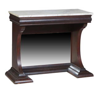
American Classical Carved Mahogany Marble Top Pier Table, 19th c., H.- 34 1/4 in., W.- 41 in., D.-Crescent City Auction Gallery4.3(233)See Sold PriceMar 01, 2024
Continental School, "Portrait of a Woman in Mourning," 19th c., H.- 29 1/2 in., W.- 24 1/4 in.,Crescent City Auction Gallery4.3(233)See Sold PriceMar 01, 2024
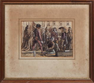
Theodore Blake Wirgman (British, 1848-1925), "The Executioner," 19th c., H.- 6 in., W.- 8 5/8 in.,Crescent City Auction Gallery4.3(233)See Sold PriceMar 01, 2024
Johann Homann Hand-Colored Map Engraving, c. 1730Auctions at Showplace4.6(744)See Sold PriceMar 17, 2024
Willem Blaeu, Etc. 17th C. Antiquarian Maps, 2Auctions at Showplace4.6(744)See Sold PriceMar 17, 2024
4 FRAMED HAND COLORED 19THC. ITALIAN ENGRAVINGS IN 2 FRAMES. ROME, FLORENCE, CAPO DI MONTE (28 1/4"Carlsen Gallery, Inc.4.6(165)See Sold PriceMar 03, 2024
Two Hand-Colored 19th Century Maps of New Orleans and Louisiana, Larger- H.- 12 1/2 in., W.- 15 1/2Crescent City Auction Gallery4.3(233)See Sold PriceMar 08, 2024
Continental School, "Child Holding a Shoe," 19th c., H.- 21 in., W.- 17 in., Framed- H.- 26 1/2 in.,Crescent City Auction Gallery4.3(233)See Sold PriceMar 09, 2024
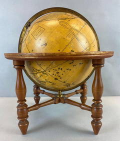
Antique Josiah Loring Terrestrial 1850s GlobeMatthew Bullock Auctioneers4.7(1.9k)See Sold PriceMar 02, 2024
Rare 19thc Colton Map, Argentine Republic, Chile, Uruguay, PataguayConnoisseur Auctions3.9(337)See Sold PriceMar 16, 2024