Sold1826 MAP OF THE EAST COAST OF THE UNITED STATES"United States Delineated by Marcella Woodward Columbia March 17, 1826." pen and ink, watercolor. 17 1/2 x 22 1/2 inches. *Note: School girl work after "School Atlas to Accompany Woodbridge's RudimentSee Sold Price
East Coast of United States 1825 Antique 19C. MapAtlantic Coastline 19 C. Map of The East Coast of United States. The title is "Partie des Etats- Unis #51". The map is dated 1825 lower right and includes the entire Atlantic coastline. The hand colorSee Sold Price
SoldGottschalk School Roompainted wood exterior with lithographed paper floor and wall trim, one wall with partial east coast United States map in German and other with coat hooks (missing several pegs), offered with several pSee Sold Price
SoldUnited States of North America Cartes des Etas Unis dePierre Francois Tardieu. Paris, 1812. Engraving with hand-color. Sheet sizes - top: 25 1/2” x 31”; bottom: 24 1/2” 31 1/2”. A very informative map of the east coast of the United States; fromSee Sold Price
MAP: United States - East Coast. Thames River New York London Harbor Long Island to NorwichDescription: United States - East Coast Connecticut - New York. Thames River/ New York London Harbor Long Island to Norwich. Published at Washington D.C. US Department of Commerce, Environmental ScienSee Sold Price
MAP: United States - East Coast. New York HarborDescription: United States - East Coast. New York Harbor. Published at Washington D.C. US Department of Commerce, National Oceanic Service. Measurement approximate: 38 x 35 Inches. Material: PaperSee Sold Price
MAP: United States - East Coast/ New York. New Jersey/ Hudson RiverDescription: United States - East Coast/ New York. New Jersey/ Hudson River/ New York to Wappinger Creek. PUBLISHED at Washington DC. US Department of Commerce, NATIONAL OCEANIC AND ATMOSPHERIC ADMINISee Sold Price
MAP: United States - East Coast. Maryland. Chesapeake Bay/Sandy Point to Susquehanna RiverDescription: United States - East Coast. Maryland. Chesapeake Bay/Sandy Point to Susquehanna River. Published at Washington D.C. US Department of Commerce, National Oceanic Service. Measurement approxSee Sold Price
MAP: United States - East Coast. Virginia/Chesapeake Bay EntranceDescription: United States - East Coast. Virginia/Chesapeake Bay Entrance. Published at Washington D.C. US Department of Commerce, National Oceanic Service. Measurement approximate: 38 x 35 Inches. MaSee Sold Price
MAP: United States - East Coast. Maryland - Virginia Chesapeake BayDescription: United States - East Coast. Maryland - Virginia Chesapeake Bay. Smith Point to Cove Point. Published at Washington D.C. US Department of Commerce, National Oceanic Service. Measurement apSee Sold Price
Map: United States - East coast/ Gulf of Maine and Georges BankDescription: United States - East coast/ Gulf of Maine and Georges Bank. Published at Washington D.C. US Department of Commerce, National Oceanic Service. Measurement approximate: 38 x 35 Inches. MateSee Sold Price
MAP: United States - East Coast. Massachusetts. Boston Inner HarborDescription: United States - East Coast. Massachusetts. Boston Inner Harbor. Published at Washington D.C. US Department of Commerce, National Oceanic Service. Measurement approximate: 38 x 35 Inches.See Sold Price
MAP: United States - East Coast. Massachusetts/Boston HarborDescription: United States - East Coast. Massachusetts/Boston Harbor. Published at Washington D.C. US Department of Commerce, National Oceanic Service. Measurement approximate: 38 x 35 Inches. MateriaSee Sold Price
MAP: United States - East Coast/ Approaches to New York/ Nantucket ShoalsDescription: United States - East Coast/ Approaches to New York/ Nantucket Shoals to Five Fathom Bank. For LORAN - C coverage - see reverse side. Published at Washington D.C. US Department of CommerceSee Sold Price
MAP: United States - East Coast. Connecticut - New York. Long Island Sound - Eastern PartDescription: United States - East Coast. . Connecticut - New York. Long Island Sound - Eastern Part. Published at Washington D.C. US Department of Commerce, Environmental Science services AdministratiSee Sold Price
United States - East Coast Virginia. Hampton Roads ...Title/Content of Map: United States - East Coast Virginia. Hampton Roads ... Cartographer: U.S. COAST & GEODETIC SURVEY Date: 01 01 1930 Publisher: U.S.C. & G.S. Size: 34Height - 40.5Width Large insetSee Sold Price
United States East Coast – Block Island, Nantucket,Title/Content of Map: United States East Coast – Block Island, Nantucket, Rhode IslandBritish Admiralty Chart 2492, published 1887 Date: 1887 Cartographer: British Admiralty Size: 28x41 in Hardly usSee Sold Price
SDUK: Antique Map of United States East Coast, 1844Title/Content of Map: 'NORTH AMERICA, SHEET VI., New York, Vermont, Maine, New Hampshire, Massachusetts, Connecticut, Rhode Island, New Jersey' Date Printed: This map was originally published by BaldwSee Sold Price
United States East Coast Maine Mapof Deer Island Thorofare and Casco Passage, 22 x 35 in yellows and blues, good condition.See Sold Price
SoldRichfield News Map of Europe | the World | Europe AirMap Title: Richfield News Map of Europe | the World | Europe Air Mileage Distances | Map of United States East Coast Defense Bases | Africa Publication Date: 2/14/1941Cartographer: RAND MCNALLY & COMPSee Sold Price
SoldNautical Map / Sea Chart, #1212 Eastern Long IslandDescription: Nautical Map / Sea Chart, United States East Coast, Connecticut - New York, Long Island Sound, Eastern Part, 12th edition feb 10 / 69 ; all measurements are approximate; Folded; ShippingSee Sold Price
SoldNautical Map / Sea Chart, #1211 MarthaDescription: Nautical Map / Sea Chart, United States East Coast, Rhode Island - Connecticut - New York, Block Island Sound and Approaces9th edition, dec 23/63 stamped CORRECTED ONLY FOR AIDS & HAZARDSSee Sold Price
SoldNautical Map / Sea Chart, #362 Block Island Sound andDescription: Nautical Map / Sea Chart, United States East Coast, New York, Long Island, Block Island Sound and Gardiner's Bay, 6th edition, Feb 10/69; Shipping: $20; different rate to California, AlasSee Sold Price
New York, United States – East Coast, Approaches to NewTitle/Content of Map: New York, United States – East Coast, Approaches to New YorkBritish Admiralty Chart 2491, published in 1877 Date: 1877 Cartographer: British Admiralty Material/Medium: thick paSee Sold Price
Alton S. Tobey, Toward the Arctic SunLotus International Auctions, LLC4.6(153)See Sold PriceMar 03, 2024
CHARTS: United States - East Coast New Jersey/ PASSAIC AND HACKENSACK RIVERSChurchill Galleries3.7(213)See Sold PriceFeb 26, 2024
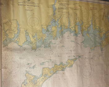
CHART: UNITED STATES - EAST COAST/ RHODE ISLAND - CONNECTICUT - NEW YORK/ Fishers IslandChurchill Galleries3.7(213)See Sold PriceFeb 26, 2024
CHART: UNITED STATES - EAST COAST MASSACHUSETTS/ HYANNIS HARBORAND VICINITYChurchill Galleries3.7(213)See Sold PriceFeb 26, 2024
Chart: United States- East Coast/ NORTH CAROLINA/ RIVER INLET TO CAPE FEAR.Churchill Galleries3.7(213)See Sold PriceFeb 26, 2024
CHART: UNITED STATES - EAST COAST NEW YORK/ HUDSON RIVER/ POUGHKEEPSIE TO HUDSONChurchill Galleries3.7(213)See Sold PriceFeb 26, 2024
Cooke, George 1801 Antique Map. United States of AmericaAlbion Auctions4.6(336)See Sold PriceMar 01, 2024
Blackie (Pub) 1882 Folio Map. United States of North AmericaAlbion Auctions4.6(336)See Sold PriceMar 01, 2024
Robert de Vaugondy - Map of Canada - Mer de l' Ouest or Sea of the West and a Northwest PassageProverde Auctions4.3(3)See Sold PriceFeb 28, 2024
Pair of Lenox Glass Candlestick Holders, Artic BloomLion and Unicorn4.7(1.8k)See Sold PriceMar 07, 2024
Rollin Karg Dichroic Art Glass Sculpture on Stand, SignedLion and Unicorn4.7(1.8k)See Sold PriceMar 07, 2024
Mill Creek Studios Composite Sculpture, Arctic WolfLion and Unicorn4.7(1.8k)See Sold PriceMar 07, 2024
Mill Creek Studios Composite Sculpture, Family PrideLion and Unicorn4.7(1.8k)See Sold PriceMar 07, 2024
Mill Creek Studios Composite Sculpture, Soul MatesLion and Unicorn4.7(1.8k)See Sold PriceMar 07, 2024