SoldLarge map of U.S. 1852Heading: Author: Smith, John Calvin Title: Colton's Map of the United States including Canada and a large portion of Texas. Showing the Base Meridian and Township Lines of the U.S. Surveys, the LandsSee Sold Price
Large map of U.S. 1852Heading: Author: Smith, John Calvin Title: Colton's Map of the United States including Canada and a large portion of Texas. Showing the Base Meridian and Township Lines of the U.S. Surveys, the LandsSee Sold Price
SoldLarge Colton map of U.S. 1852Heading: (United States) Author: Colton, J.H. Title: Map of the United States of America, the British Provinces, Mexico, the West Indies and Central America, with Part of New Granada and Venezuela PlaSee Sold Price
1985 Large Map- U.S. POTATO HARVEST SEASONS By COUNTY****** Real potato map*** W28.5" H22 1/4" Very nice and definitely very rare !!!!! Don't miss your treasure! ********See Sold Price
1985 Large Map- U.S. POTATO HARVEST SEASONS By COUNTY**** Real potato map*** W28.5" H22 1/4" Very nice ********See Sold Price
1985 Large Map- U.S. POTATO HARVEST SEASONS By COUNTYReal potato map*** W28.5" H22 1/4"See Sold Price
SoldLot of 3 large maps, US Geological Survey by PikeLot of 3 large maps, US Geological Survey by Pikes Peak Lithographing Co, CO. 1) Florida 1995, 2) Georgia 1994, 3) Michigan 1995. Approximate size 44" x 47".See Sold Price
SoldLarge map of U.S. Surveys 1872Heading: (United States) Author: General Land Office Title: Map of the United States and Territories, Showing the Extent of Public Surveys and Other Details Place Published: Washington Publisher:See Sold Price
SoldLarge map of U.S. from G.L.O. 1866Title: Map of the United States and Territories. Shewing the Extent of Public Surveys and other Details... under the Direction of Joseph S. Wilson, Commissioner Author: United States General Land OffiSee Sold Price
SoldLarge map of U.S. at start of Civil WarHeading: Author: Stanford, Edward Title: Stanford's Railway and County Map of the United States and Territories Place Published: London Publisher: Date Published: 1861 Description:See Sold Price
Large map of U.S. Railroads 1918Title: General Railway Map Engraved Expressly for the Official Guide of the Railways and Steam Navigation Lines of the United States... Author: ** Description: Engraved map, outline color, sectioned &See Sold Price
SoldVery large map of U.S. by J.C. Smith 1845Heading: Author: Smith, John Calvin Title: Map of the United States including Canada and a large portion of Texas. Showing the Base Meridian and Township Lines of the U.S. Surveys, the lands allottedSee Sold Price
J.C. Smith's large map of U.S. 1854Heading: Author: Smith, John Calvin Title: Colton's Map of the United States including Canada and a large portion of Texas. Showing the Base Meridian and Township Lines of the U.S. Surveys, The LandsSee Sold Price
SoldLarge map of U.S. from G.L.O. 1866Title: Map of the United States and Territories. Shewing the Extent of Public Surveys and other Details... under the Direction of Joseph S. Wilson, Commissioner Author: United States General Land OffiSee Sold Price
SoldJ.C. Smith's large map of U.S. 1854Heading: Author: Smith, John Calvin Title: Colton's Map of the United States including Canada and a large portion of Texas. Showing the Base Meridian and Township Lines of the U.S. Surveys, The LandsSee Sold Price
SoldLarge map of U.S. 1850Heading: Author: Smith, John Calvin Title: Map of the United States including Canada and a large portion of Texas. Showing the Base Meridian and Township Lines of the U.S. Surveys, the Lands allottedSee Sold Price
SoldLarge map of U.S. oil pipe lines, 1928Heading: (Oil) Author: Title: Map of oil trunk pipe lines in the United States: With locations of refineries shown by circles Place Published: Tulsa, OK Publisher:Petroleum Publishing Co. Date PSee Sold Price
Sold1852 US Large One Cent CoinWhether you are a seasoned collector or new to numismatics, there is something here for you! This auction includes over 1000 lots that have been in storage and untouched for 40 years. All coins are soSee Sold Price
SoldRadefeld/Meyer: Antique Map of U.S. & Mexico, 1852Vereinigte Staaten von Nord-America und Mexico. A highly detailed map of the United States and Mexico from Meyer's Groschen-Atlas, showing the pre-Gadsen Purchase border between the U.S. and Mexico anSee Sold Price
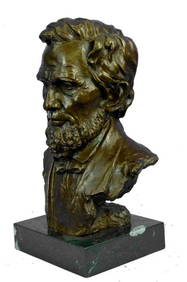
Large US President Abraham Lincoln Bronze Bust StatueWeatherham Estate Treasures3.9(157)See Sold PriceMar 07, 2024
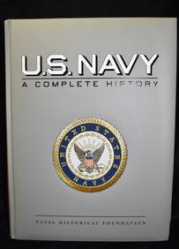
U.S. NAVY - A Complete History by Goodspeed, M. Hill 2003 MintNorth American Artifact Auctions4.6(184)See Sold PriceApr 20, 2024
1736 LARGE MAP OF SILESIA POLAND OPPAVIENSIS antique 25 by 34 3/4"Jasper524.5(9.8k)See Sold PriceFeb 27, 2024
1736 LARGE MAP OF SILESIA POLAND KARNOVIENSIS antique 25 x 4 3/4" Duchy of KrnovJasper524.5(9.8k)See Sold PriceFeb 27, 2024
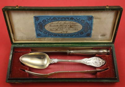
German by CB Geiss Sterling Silver Traveling Set 3-pc Set, Original box 8 1/8"Mynt Auctions4.6(689)See Sold PriceFeb 27, 2024
Central Africa. Congo Free State Rhodesia German East Africa. STANFORD 1896 mapJasper524.5(9.8k)See Sold PriceFeb 28, 2024
Stanford, Edward 1901 Large Map. Geological Map of the British IslesAlbion Auctions4.6(341)See Sold PriceMar 01, 2024
Stanford, Edward 1901 Large Map. Hydrographical Map of the British IslesAlbion Auctions4.6(341)See Sold PriceMar 01, 2024
Stanford, Edward 1901 Large Map. Stereographical Map of The British IslesAlbion Auctions4.6(341)See Sold PriceMar 01, 2024
Perry, Matthew C. 1856 Large Map. Shah Bay, Lew Chew I. JapanAlbion Auctions4.6(341)See Sold PriceMar 01, 2024