SoldEMANUEL BOWEN (British 1693-1767) TWO COPPERPLATEEMANUEL BOWEN (British 1693-1767) TWO COPPERPLATE ENGRAVED MAPS, "Old Greenland ...," AND "New Italy ...," LONDON, C. 1747, originally published in Bowen's "A Complete System of Geography ...," with lSee Sold Price
SoldMap by Emanuel Bowen of Spain and PortugalEmanuel Bowen (British, 1693-1767),"A New & Accurate Map of Spain & Portugal," hand-colored copper engraved map, with a figurative title cartouche in the top right corner and two inset maps of a ChartSee Sold Price
SoldJohn Owen (18th Century) and Emanuel Bowen (1693-1767)John Owen (18th Century) and Emanuel Bowen (1693-1767) British. "The Road from London to Portsmouth", c.1720, Map, Two Sided, 7.25" x 9.5".See Sold Price
SoldEmanuel Bowen (British, 1693-1767) A New & Accurate MapEmanuel Bowen (British, 1693-1767) A New & Accurate Map of all the Known World. Engraving with original hand-coloring, published in London 12 1/2" x 21 1/4" Frame: 24 1/4" x 32 3/4"See Sold Price
SoldAfter Emanuel Bowen (1693-1767) British. "SurreyAfter Emanuel Bowen (1693-1767) British. "Surrey", Map, 21" x 28.25".See Sold Price
SoldEmanuel Bowen (1693-1767) British. "An Accurate Map ofEmanuel Bowen (1693-1767) British. "An Accurate Map of Hamp Shire", Map, 16.25" x 20".See Sold Price
SoldJohn Owen (17th - 18th Century) British and EmanuelJohn Owen (17th - 18th Century) British and Emanuel Bowen (1693-1767) British. "The Road from London to Chichester, a Map of Surrey", Double Sided Map, Unframed, 7.75" x 5.25", together with a Map bySee Sold Price
SoldAfter Emanuel Bowen (1693-1767) British. "Norfolk",After Emanuel Bowen (1693-1767) British. "Norfolk", Map, Unframed, 7" x 7.75", together with Four similar Maps, "Suffolk", "Essex", "Hertford Shire", and Huntingdon Shire", Five (5).See Sold Price
SoldAfter Emanuel Bowen (1693-1767) British. "NorthamptonAfter Emanuel Bowen (1693-1767) British. "Northampton Shire", Map, Unframed, 7.5" x 7", together with Nine similar Maps, "Oxford Shire", "Lancashire", "Lincolnshire", "Nottingham Shire", "Stratford ShSee Sold Price
SoldEmanuel Bowen (1693-1767) British. "A Map of RadnorEmanuel Bowen (1693-1767) British. "A Map of Radnor Shire", Map, Unframed, 7.25" x 5", and Five other various Maps by different hands, Six (6).See Sold Price
SoldEmanuel Bowen (1693-1767) British. "A Correct Map ofEmanuel Bowen (1693-1767) British. "A Correct Map of the South East Part of Germany", Map, 14" x 16.5"See Sold Price
SoldTwo Copies of Emanuel Bowen (1693-1767), "A New Map ofTwo Copies of Emanuel Bowen (1693-1767), "A New Map of Georgia, Florida, Louisiana, Carolina," 1748, H.- 15 3/4 in., W.- 20 in.See Sold Price
Sold"Terra FIrma and Caribbe Islands", Emanuel Bowen"A New and Accurate Map of the Terra Firma and the Caribbe Islands", an 18th century map by Emanuel Bowen (1693-1767). An engraved and hand colored map in two pages with central fold crease, framed. 1See Sold Price
SoldEmanuel Bowen (1693-1767, "Nieuwe en Algemeene KaartEmanuel Bowen (1693-1767, "Nieuwe en Algemeene Kaart van America, Getrokken mil. Landkarten," 1783, hand colored, H.- 18 1/2 in., W.- 23 in.See Sold Price
SoldEmanuel Bowen (1693-1767), "A Correct Map of UnitedEmanuel Bowen (1693-1767), "A Correct Map of United States of North America per Treaty of Bankes," 1784, hand colored, H.- 15 in., W.- 19 in.See Sold Price
SoldEmanuel Bowen Map of the Eastern or Indian OceanEmanuel Bowen (1693-1767), "A New and Accurate Map of the East India Islands Laid down according to the latest discoveries and agreeable to the most approved Maps & Charts, The whole being regulated bSee Sold Price
SoldGrp: Maps of the West Indies/CaribbeanGroup of seven maps of Latin America and the Caribbean, including maps of the West Indies, a map of the Bay of Cartagena, a map of Antigua by Emanuel Bowen (1693-1767), and a map of Cuba. SKU: 03489See Sold Price
SoldGrp: 10 Maps of Africa 17th-19th c.Ten maps of Africa by cartographers including Pierre Duval (1618–1683), F. Von. Stulpnagel, Emanuel Bowen (1693-1767), and Abraham Ortelius (1527-1598). Includes three maps of Morocco and thSee Sold Price
SoldEmanuel Bowen (1693-1767, "A New and Accurate Chart ofEmanuel Bowen (1693-1767, "A New and Accurate Chart of the Western Atlantic Ocean," 1778, H.- 9 in., W.- 14 1/2 in.See Sold Price
Sold1766 Emanuel Bowen Map East India IslandsEmanuel Bowen (1693-1767), "A New and Accurate Map of the East India Islands Laid down according to the latest discoveries and agreeable to the most approved Maps & Charts, The whole being regulated bSee Sold Price
SoldEmanuel Bowen, NegrolandColored engraving. Emanuel Bowen (1693-1767). Approx. 14" H x 17" W sight, 19" H x 22" W framed. From the estate of Arthur Adlman, New York, NY and Cascais, Portugal. (5229) Fold marks.See Sold Price
SoldEmanuel Bowen, map Eastern SeaboardEmanuel Bowen, map Eastern Seaboard, Emanuel Bowen (British, 1694-1767), "A New and Accurate Map of New Jersey, Pennsylvania, New York, and New England", c. 1744, from Maryland to Nova Scotia, hand-coSee Sold Price
SoldEmanuel Bowen, "New & Accurate Map of Brasil"Emanuel Bowen (English, 1693-1767). "A New & Accurate Map of Brasil, Divided into its Captainships". An engraved map, with vibrant hand coloring, depicting Brasil and a segment with the Isle of St. KaSee Sold Price
SoldEMANUEL BOWEN (BRITISH, 1720-1767) MAP OF THE SOUTHEASTEMANUEL BOWEN (BRITISH, 1720-1767) MAP OF THE SOUTHEAST hand-colored engraving on laid paper, A New and Accurate Map of the Provinces of North & South Carolina, Georgia, &c. Drawn from late Surveys anSee Sold Price
LATE 17TH C. FRENCH MAP OF THE NEW WORLD BY ALEXIS-HUBERT JAILLOT (1632-1712)Thomaston Place Auction Galleries4.4(386)See Sold PriceFeb 24, 2024
RARE 1638 HONDIUS MAP OF BERMUDA, FRAMEDThomaston Place Auction Galleries4.4(386)See Sold PriceFeb 24, 2024
17TH C. ENGLISH CHART OF THE THAMES BY CAPT. GREENVILLE COLLINS, 1693-4, FRAMEDThomaston Place Auction Galleries4.4(386)See Sold PriceFeb 24, 2024
1585 OXONIUM VINDESORIUM (OXFORD AND WINDSOR CASTLE) BY BRAUN AND HOGENBERG, FRAMEDThomaston Place Auction Galleries4.4(386)See Sold PriceFeb 24, 2024
ABRAHAM ORTELIUS (1527-1598) MAP OF ROMAN GAUL (FRANCE)Thomaston Place Auction Galleries4.4(386)See Sold PriceFeb 24, 2024
NICOLAES VISSCHER (NETHERLANDS, 1618-1709) MAP OF THE NEW WORLDThomaston Place Auction Galleries4.4(386)See Sold PriceFeb 24, 2024
WILLEM JANSZOON BLAEU (NETHERLANDS, 1571-1638) MAP OF UMBRIAThomaston Place Auction Galleries4.4(386)See Sold PriceFeb 24, 2024
WILLEM JANSZOON BLAEU (NETHERLANDS, 1571-1638)Thomaston Place Auction Galleries4.4(386)See Sold PriceFeb 24, 2024
[ARCTIC]. BOWEN, Emanuel. A New & Accurate Map of the North...Potter & Potter Auctions4.6(539)See Sold PriceMar 07, 2024
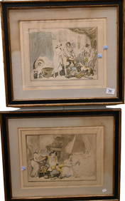
Marguerite Kirmse (British, 1885-1954), Two Terrier EtchingsLeland Little4.5(692)See Sold PriceFeb 29, 2024
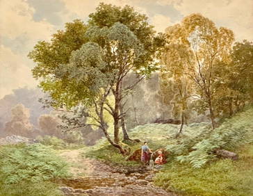
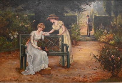
James Jackson Curnock Watercolor, Two Girls Gathering Water at the SpringNeue Auctions4.6(353)See Sold PriceMar 02, 2024
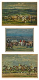
E. S. England (British, act. 1890-1910), Two Riding Scenes, H.- 30 in., W.- 20 in., Framed- H.- 36Crescent City Auction Gallery4.3(229)See Sold PriceMar 09, 2024
Athern HO Gauge British Columbia Railway two-tone green Diesel/Spirit of 76 Dummy DieselHarris Toy and Train Auctions4.5(122)See Sold PriceMar 01, 2024
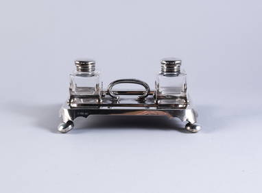
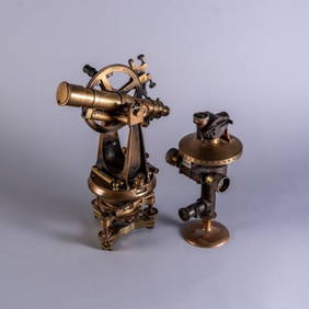
TWO BRITISH BRASS SCIENTIFIC INSTRUMENTSPridham's Auctions & Appraisals4.7(223)See Sold PriceMar 02, 2024


![[ARCTIC]. BOWEN, Emanuel. A New & Accurate Map of the North... (1 of 1)](https://p1.liveauctioneers.com/928/318880/171360917_1_x.jpg?height=282&quality=70&version=1707501302)