Map, antique, Depot de la MarineUnframed antique engraved map, Carte Generale des Costes de Bretagne, French 18th/19th century, published by the Depot de la Marine, sheet: 26''h x 38''wSee Sold Price
SoldMap, antique, Depot de la MarineUnframed antique engraved map, Carte Generale des Costes de Bretagne, French 18th/19th century, published by the Depot de la Marine, sheet: 26''h x 38''wSee Sold Price
SoldDepot de la Marine: Antique Map of Gulf of Mexico, 1800Map: Carte des Côtes du Golfe du Mexique Cartographer: Collin/Besançon/Dépôt Général de la Marine/ Place & Date: Paris / 1800 (Year IX) Size: 35 5/8" x 23 3/4" Condition: b&w; a beautifully presSee Sold Price
SoldDepot de la Marine: Antique Map of Jamaica, 1786Map: Carte de l'Ile de la Jamaique Cartographer: Dépôt de la Marine Place & Date: Paris / 1786/1799 Size: 34" x 23" Condition: b&w; ink spots along left margin This superbly engraved, large-scale D�See Sold Price
Depot: Antique Chart Map of Gulf of Gascogne: 1790Map: Carte Reduite de Golfe de Gascogne Dressee au Depot des Cartes et Plans de la Marine et des Colonies, Pour le Service des Vaisseaux du Roi en 1790 Date Printed: 1790 Cartographer: Depot de la MarSee Sold Price
Antique World Map, Mercator’s Projection, 1835“Carte Hydrographique des parties Connues de la Terre Dressee sur la Projection de Mercator” by C. L. Gressier. Published by the Depot-General de la Marine, Paris, 1835. Measures 23” tall, 34 3/See Sold Price
Large Antique French 1863 A.H.Dufour Map of South America Linen backAuguste Henri Dufour, born in Paris in 1795 and died in 1865, is a French geographer.He studied with Lapie and worked with him on several maps of the Depot de la Marine. In 1824, he published for theSee Sold Price
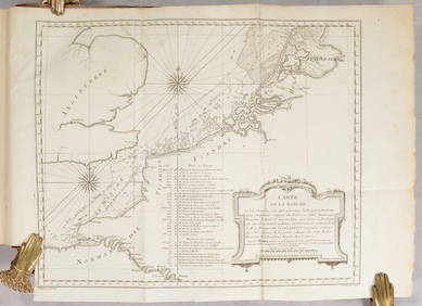
Large Antique French 1863 A.H.Dufour Map of North America Linen backAuguste Henri Dufour, born in Paris in 1795 and died in 1865, is a French geographer.He studied with Lapie and worked with him on several maps of the Depot de la Marine. In 1824, he published for theSee Sold Price
Large Antique French 1863 A.H.Dufour Map of NorthAuguste Henri Dufour, born in Paris in 1795 and died in 1865, is a French geographer.He studied with Lapie and worked with him on several maps of the Depot de la Marine. In 1824, he published for theSee Sold Price
Large Antique French 1863 A.H.Dufour Map of South America Linen backAuguste Henri Dufour, born in Paris in 1795 and died in 1865, is a French geographer.He studied with Lapie and worked with him on several maps of the Depot de la Marine. In 1824, he published for theSee Sold Price
Large Antique French 1863 A.H.Dufour Map of SouthAuguste Henri Dufour, born in Paris in 1795 and died in 1865, is a French geographer.He studied with Lapie and worked with him on several maps of the Depot de la Marine. In 1824, he published for theSee Sold Price
Large Antique French 1863 A.H.Dufour Map of North America Linen backAuguste Henri Dufour, born in Paris in 1795 and died in 1865, is a French geographer.He studied with Lapie and worked with him on several maps of the Depot de la Marine. In 1824, he published for theSee Sold Price
Large Antique French 1863 A.H.Dufour Map of South America Linen backAuguste Henri Dufour, born in Paris in 1795 and died in 1865, is a French geographer.He studied with Lapie and worked with him on several maps of the Depot de la Marine. In 1824, he published for theSee Sold Price
SoldAN ANTIQUE TEXAS/LOUISIANA BORDER SABINE RIVER SURVEYAN ANTIQUE TEXAS/LOUISIANA BORDER SABINE RIVER SURVEY MAP, "Golfe du Mexique-Texas, Reconnaissance: De la Passe de la Sabine: Dépot de Cartes Plans de la Marine," PARIS,1867, hand colored lithogrSee Sold Price
SoldDepot de la Marine: Haiti 1788, Gulf & Island ofTitle/Content of Map: Depot de la Marine: Haiti 1788, Gulf & Island of Gonave Date Printed: 1788, Paris Cartographer: Depot-general de la Marine / Lieudé de Sepmanville Size: 35" x 23" A scarce, largSee Sold Price
MAP - Corsica. Depot de la MarineL'Ile-Rousse, Corsica. Depot de la Marine, Plan du Mouillage de l'Ile Rousse..., 1829 (dated). Black & White. This scarce chart by French naval officer M. de Hell shows L'Ile-Rousse on Corsica. The ciSee Sold Price
Sold1 piece. Hand-Colored Engraved Map. Depot General1 piece. Hand-Colored Engraved Map. Depot General de la Marine, pub. Carte Reduite des Cotes et de l'Interieur de la Presquile de la Floride,..." [Paris], 1780. 23 3/4 x 17 1/2 inches; 603 x 445 mm, tSee Sold Price
Sold1 piece. Hand-Colored Engraved Map. Depot General1 piece. Hand-Colored Engraved Map. Depot General de la Marine, pub. Carte d'Une Partie de Cotes de la Floride et de la Louisane." [Paris], 1778. 17 1/4 x 23 3/4 inches; 438 x 603 mm, trimmed to 1 plaSee Sold Price
SoldRussian Wall MapUnknown Artist (Russian, Early 19th Century). Russian Wall Map with Depot De La Marine Stamp. Engraved map on six sheets. Russia, 19th Century. 37 1/4" x 62" sheet. Early Map of the Russian ContinentSee Sold Price
MAP - Calvi, Corsica. Depot de la MarineCalvi, Corsica. Depot de la Marine, Plan des Golfes de Calvi et de Revellata Situes a la Cote Occidentale de l'Ile de Corse... , 1829 (dated). Black & White. This scarce chart by French naval officerSee Sold Price
Auguste Henri Dufour, born in Paris in 1795 and died in 1865, is a French geographer.He studied withAuguste Henri Dufour, born in Paris in 1795 and died in 1865, is a French geographer.He studied with Lapie and worked with him on several maps of the Depot de la Marine. In 1824, he published for theSee Sold Price
SoldMAP, Saint Denis, Reunion, Depot de la MarineSaint Denis, Reunion. Depot de la Marine, Plan du Mouillage de Saint Denis (Ile de Bourbon), 1843 (dated). Black & White. This detailed navigational chart shows Saint Denis on the northern tip of ReunSee Sold Price
MAP, Saint Denis, Reunion, Depot de la MarineSaint Denis, Reunion. Depot de la Marine, Plan du Mouillage de Saint Denis (Ile de Bourbon), 1843 (dated). Black & White. This detailed navigational chart shows Saint Denis on the northern tip of ReunSee Sold Price
Depot de la Marine Map of the Carribean / FloridaFour Maps of the Carribean / Florida (Baie de Tampa, Port de San Agustin, Embouchure de la Riviere San Juan, Embouchure de la Riveiere Nassau). Engraving from 'Pilote de l'Amerique meridionale et desSee Sold Price
17TH C. ANTIQUE MAP SIEGE OF LA ROCHELLE, FRANCE, FRAMEDThomaston Place Auction Galleries4.4(386)See Sold PriceFeb 24, 2024
Map of St. Kitts and Nevis Depot de la Marine, Paris, 1758Global Auctions Company4.3(36)See Sold PriceMar 03, 2024
Carte de la Barbarie… l'empire de Maroc… North Africa Morocco. LAPIE 1829 mapJasper524.5(9.8k)See Sold PriceFeb 28, 2024
Partie de la Coste d'Afrique depuis Tanit…' Southern Mauritania BELLIN 1746 mapJasper524.5(9.8k)See Sold PriceFeb 28, 2024
Partie de la Coste d'Afrique'. Southern Mauritania BELLIN/SCHLEY 1747 old mapJasper524.5(9.8k)See Sold PriceFeb 28, 2024
La Barbarie de la Nigritie et de la Guinée'. West Africa. DE L’ISLE 1745 mapJasper524.5(9.8k)See Sold PriceFeb 28, 2024
FRENCH SUDAN (Now Mali). Soudan Français. Bamako city plan de la ville 1929 mapJasper524.5(9.8k)See Sold PriceFeb 28, 2024
Royaumes, Etats et Pays de la Haute Guinée. Gulf of Guinea. BONNE 1788 old mapJasper524.5(9.8k)See Sold PriceFeb 28, 2024
Carte de la partie septentrionale d'Afrique, ou de la Barbarie… BONNE 1780 mapJasper524.5(9.8k)See Sold PriceFeb 28, 2024
Partie de la Coste de Guinée' Sierra Leone Liberia coast BELLIN/SCHLEY 1747 mapJasper524.5(9.8k)See Sold PriceFeb 28, 2024
Carte de l'Afrique propre, de la Numidie… North Africa. LAPIE 1829 old mapJasper524.5(9.8k)See Sold PriceFeb 28, 2024
Plan de la Baye & Isle d'Arguim'. Mauritania. Arguin island. BELLIN 1746 mapJasper524.5(9.8k)See Sold PriceFeb 28, 2024
Partie de la Coste de Guinée'. Sierra Leone & Liberia coast. BELLIN 1747 mapJasper524.5(9.8k)See Sold PriceFeb 28, 2024
FRENCH SUDAN (Now Mali). Soudan Français. Bamako city plan de la ville 1938 mapJasper524.5(9.8k)See Sold PriceFeb 28, 2024
Suite de la Coste de Guinée'. Ghana Togo Benin coast. BELLIN/SCHLEY 1748 mapJasper524.5(9.8k)See Sold PriceFeb 28, 2024
Carte de L'Algérie et de la Régence de Tunis' ANDRIVEAU-GOUJON Algeria 1850 mapJasper524.5(9.8k)See Sold PriceFeb 28, 2024
FRENCH SUDAN (Now Mali). Soudan Français. Bamako city plan de la ville 1931 mapJasper524.5(9.8k)See Sold PriceFeb 28, 2024
Carte de la Haute et de la Basse Guinée. Gulf of Guinea Africa. BONNE 1780 mapJasper524.5(9.8k)See Sold PriceFeb 28, 2024
Suite de la Coste de Guinée'. Ghana Togo Benin coast. Whidah. BELLIN 1747 mapJasper524.5(9.8k)See Sold PriceFeb 28, 2024
Jacques Nicolas Bellin - Antique Map - Vue de la Rade de Tiniam, double antique coast view of theProverde Auctions4.3(3)See Sold PriceFeb 28, 2024