SoldRare 1849 chart of West Coast by ImrayHeading: Author: Imray, James F. Title: Chart of the Coast of California from San Blas to San Francisco Drawn Chiefly from the Spanish Surveys, the Charts of Vancouver, etc. The Whole Much Improved bSee Sold Price
SoldRare 1849 chart of West Coast by ImrayHeading: Author: Imray, James F. Title: Chart of the Coast of California from San Blas to San Francisco Drawn Chiefly from the Spanish Surveys, the Charts of Vancouver, etc. The Whole Much Improved bSee Sold Price
Chart of West Coast of Central America 1849Heading: Author: Imray, James F. Title: Chart of the Western Coast of North America extending from the Gulf of Nicoya to San Blas Compiled chiefly from the Spanish Surveys, the whole much improved frSee Sold Price
SoldChart of West Coast of Central America 1849Heading: Author: Imray, James F. Title: Chart of the Western Coast of North America extending from the Gulf of Nicoya to San Blas Compiled chiefly from the Spanish Surveys, the whole much improved frSee Sold Price
Blueback coasting chart of California—1849Blueback coasting chart of California—1849 316. [MAP]. IMRAY, James. Chart of the Coast of California from San BlaSee Sold Price
SoldRare chart of West Coast of North AmericaHeading: (North America - West Coast) Author: Title: Carte de la côte occidentale d'Amérique comprise entre les iles de la Reine Charlotte et la port de San Diego (Amérique Anglaise, Californie).See Sold Price
SoldRare chart of West Coast 1852Heading: Author: Findlay, A.G. Title: The Coasts of California and Oregon between Pt. Conception and De Fuca Strait Place Published: London Publisher: Published by R.H. Laurie Date Published: </See Sold Price
SoldRare chart of West Coast of North America 1825Heading: (North America) Author: Espinosa y Tello, Josef Title: Carta general para las navegaciones á la India Oriental por el Mar del Sur y el Grande Oceano que separa el Continente Americano del AsSee Sold Price
SoldLarge chart of West Coast 1883Heading: Author: Imray, James F. Title: West Coast of North America From San Blas to San Francisco Place Published: London Publisher:Published by James Imray and Son Date Published: 1883See Sold Price
SoldBLUEBACK CHART OF THE WEST COAST OF NORTH AMERICA, FROMBLUEBACK CHART OF THE WEST COAST OF NORTH AMERICA, FROM SAN BLAS TO SAN FRANCISCODated 1874Published by James Imray and Son, London.Approx. 51.5" x 40.75".See Sold Price
Sold1849 Imray Chart of the Pacific Coast of Mexico to SanTitle: 1849 Imray Chart of the Pacific Coast of Mexico to San Blas and Central America -- Chart of the Western Coast of North America extending from the Gulf of Nicoya to San Blas Compiled chiefly froSee Sold Price
1849 Imray Chart of the Pacific Coast of Mexico to SanReserve Reduced! Title/Content of Map: 1849 Imray Chart of the Pacific Coast of Mexico to San Blas and Central America -- Chart of the Western Coast of North America extending from the Gulf of NicoyaSee Sold Price
1849 Imray Chart of the Pacific Coast of Mexico to SanTitle/Content of Map: 1849 Imray Chart of the Pacific Coast of Mexico to San Blas and Central America -- Chart of the Western Coast of North America extending from the Gulf of Nicoya to San Blas CompiSee Sold Price
1849 Imray Chart of the Pacific Coast of Mexico to SanTitle/Content of Map: 1849 Imray Chart of the Pacific Coast of Mexico to San Blas and Central America -- Chart of the Western Coast of North America extending from the Gulf of Nicoya to San Blas CompiSee Sold Price
1849 Imray Chart of the Pacific Coast of Mexico to SanItem: 1849 Imray Chart of the Pacific Coast of Mexico to San Blas and Central America -- Chart of the Western Coast of North America extending from the Gulf of Nicoya to San Blas Compiled chiefly fromSee Sold Price
SoldChart of Pacific Coast north of S.F.Heading: Author: Imray, James Title: West Coast of North America from San Francisco to Queen Charlotte Ids. Place Published: London Publisher:Published by James Imray and Son Date Published:See Sold Price
SoldBLUEBACK CHART OF THE EAST AND WEST COASTS OF SOUTHBLUEBACK CHART OF THE EAST AND WEST COASTS OF SOUTH AMERICADated 1875Published by James Imray and Son, London.40.25" x 74.5".See Sold Price
SoldMap Showing the 4 Voyages of Christopher ColumbusMap: Chart of the West Indies With the Adjacent Coast of South America, Showing The Tracks Of Don Christopher Columbus Size: Folio – 11.00 H x 15.90 W Inches Publisher: George P. Putnam 1849 New YorSee Sold Price
Imray, James. Chart of the Coast of CABlueback Coasting Chart of California — 1849 57. [MAP]. IMRAY, James. Chart of the Coast of California from San Blas to San Francisco Drawn chiefly from the Spanish Surveys, the Charts of VancouSee Sold Price
SoldBLUEBACK CHART OF ST. GEORGE'S CHANNEL, THE BRISTOLBLUEBACK CHART OF ST. GEORGE'S CHANNEL, THE BRISTOL CHANNEL AND PART OF THE WEST COAST AND ISLANDS OF SCOTLANDPublished 1853Published by James Imray and Son, London.Approx. 40.5" x 75.5".See Sold Price
SoldChart of Pacific 1849 wiith inset of S.F.Heading: (Pacific Ocean) Author: Imray, James, & Son Title: Chart of the North Pacific Ocean, Exhibiting the Eastern Shores of Asia and Western Coast of North America, from the Equator to Behrings StrSee Sold Price
SoldChart of Pacific 1849 wiith inset of S.F.Heading: Author: Imray, James, & Son Title: Chart of the North Pacific Ocean, Exhibiting the Eastern Shores of Asia and Western Coast of North America, from the Equator to Behrings Strait. With PlansSee Sold Price
Sold(16) MARINE CHARTS & (2) JACK GRAY PRINTS, ROLLEDIncluding: "Windward Passages and Gulf of Mexico, including the Bahamas and West Indies Islands", Wilson, 1899; "Puerto Rico and the Virgin Islands", Imray, 1884; "Massachusetts Bay and the Coast ChatSee Sold Price
SoldOriginal Imray & Son Nautical Chart of North Pacific,Imray & Son map of North Pacific showing the coast of Asia, including China, Manchooria, Nipon, Tungusi, Koriaki and more. The map also features Alaska and islands, British America, and the west coastSee Sold Price
Boston and Maine RR A Trip from Ocean to Ocean Book-1901JM Hobby Supply and Railroad Artifact Auctions4.4(126)See Sold PriceFeb 24, 2024
RARE HY FLASH MOTOR OIL FIVE GALLON SQUARE CAN W/ CAR & AIRPLANE GRAPHICS.Dan Morphy Auctions4.2(1.3k)See Sold PriceFeb 24, 2024
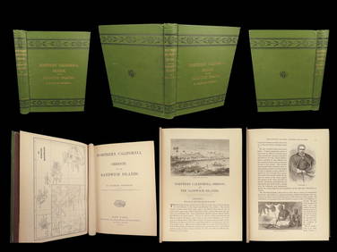
1874 HAWAII 1ed Northern California Oregon Pacific Island Travel Puget RedwoodsSchilb Antiquarian Rare Books4.8(421)See Sold PriceMar 10, 2024
2 African Very Rare Zanaki Milk Containers, Mara District, Tanzania, Mid 20th C.Material Culture4.6(765)See Sold PriceFeb 29, 2024
Ivory Coast Baule people Old big Ceremonial mask 1940 circaArs Coin Wien4.5(42)See Sold PriceFeb 25, 2024
Ivory Coast Baule people Wall mask. Traces of white pigmentation 1970Ars Coin Wien4.5(42)See Sold PriceFeb 25, 2024
Carey, pub. 1796 - A Chart of the West IndiesTrillium Antique Prints & Rare Books4.5(30)See Sold PriceFeb 24, 2024
West Indies. South Coast of Jamaica from Port Royal to Pedro Bluff.Jasper524.5(9.8k)See Sold PriceFeb 27, 2024
West coast of Africa from Cape Blanco… Arguin bay, Mauritania. LABAT 1745 mapJasper524.5(9.8k)See Sold PriceFeb 28, 2024
Gulf of Guinea. Ghana Togo Benin Nigeria. ADMIRALTY sea chart 1928 (1954) mapJasper524.5(9.8k)See Sold PriceFeb 28, 2024
South Namibia coast. Walvis Bay-Orange River ADMIRALTY sea chart 1881 (1954) mapJasper524.5(9.8k)See Sold PriceFeb 28, 2024