SoldMineral wealth of Colorado with maps 1867Heading: Author: Whitney, Joel P. Title: Colorado, In the United States of America. Schedule of Ores contributed by Sundry Persons to the Paris Universal Exposition of 1867, with some information aboSee Sold Price
Sold1869 Mineral wealth of Colorado w/ 2 mapsHeading: (Colorado) Author: Whitney, Joel P. Title: Colorado, In the United States of America. Schedule of Ores contributed by Sundry Persons to the Paris Universal Exposition of 1867, with some inforSee Sold Price
SoldHollister's Mines of Colorado with Map, 1867 [169393]The Mines of Colorado - by Hollister, Ovando J - Springfield, Mass.: Samuel Bowles & Co., 1867 Enlarged and best edition. Enlarged and best edition. Includes rare map. First published the same year inSee Sold Price
Map of Colorado Mineral LocalitiesMap showing selected mineral localities and metallic mineral deposits of Colorado, 1965 reprint, 39 1/2" x 36 1/2".See Sold Price
Map of Colorado Mineral LocalitiesMap showing selected mineral localities and metallic mineral deposits of Colorado, 1965 reprint, 39 1/2" x 36 1/2".See Sold Price
Map of Colorado Mineral LocalitiesMap showing selected mineral localities and metallic mineral deposits of Colorado, 1965 reprint, 39 1/2" x 36 1/2".See Sold Price
SoldMines of Colorado 1867 with mapHeading: Author: Hollister, Ovando J. Title: The Mines of Colorado Place Published: Springfield, Mass. Publisher:Samuel Bowles & Company Date Published: 1867 Description: [See Sold Price
SoldColorado Mineral Resources; J.P. Whitney 1867Title: Le Colorado, Aux États-Unis D'Amérique: Liste Des Minerais Fournis par Diverses Personnnes A L'Exposition Universelle De 1867 A Paris, Avec Des Renseignements Sur Le Pays et Ses Ressources AuSee Sold Price
SoldColorado Mineral Resources; J.P. Whitney 1867Heading: Author: Whitney, J. P. Title: Le Colorado, Aux États-Unis D'Amérique: Liste Des Minerais Fournis par Diverses Personnnes A L'Exposition Universelle De 1867 A Paris, Avec Des RenseigneSee Sold Price
SoldMineral Wealth, Climate etc. of Dakota by JenneyTitle: The Mineral Wealth, Climate and Rain-Fall, and Natural Resources of the Black Hills of Dakota Author: Jenney, Walter P. Description: [2], 71 pp. 1 folding map of Black Hills Preliminary Map 187See Sold Price
SoldColorado Ores at Paris Expo 1867 with mapsHeading: Author: Whitney, Joel P. Title: Colorado, In the United States of America. Schedule of Ores contributed by Sundry Persons to the Paris Universal Exposition of 1867, with some information aboSee Sold Price
SoldLarge Antique 1867 Map of Western TerritoriesAntique Original 1867 Map of Western Territories and Indian Lands including Texas, Colorado, New Mexico, and Kansas Territories | A very detailed Map depicting all of the Indian nations by name, the lSee Sold Price
Colorado Ore Deposits Mining Book Collection (126764)lot of four. 1) Mining in Colorado, USGS Professional paper.1926. Hard cover. Map included. Extremely nice. 2) Mineral Resources of Colorado. 1947. State of Colorado Mineral resources Board. ExtremelySee Sold Price
SoldIdaho Springs; Its Mines and Mineral Waters22. [COLORADO]. Idaho Springs; Its Mines and Mineral Waters. Georgetown, Colorado: Georgetown Courier Steam Printing Company and Blank Book Manufactory, 1880. 40 pp., 3 maps (full-page text illustratiSee Sold Price
SoldMaps of Western Territories and Utah (2)1) Map of Western Territories 1867. U.S. Army map of the Kansas Area, including S. Nebraska, most of Indian Territory and Texas Panhandle, Colorado and New Mexico to west of Fort Marcy. Brownstone witSee Sold Price
SoldWith 1st map to name Grand Canyon of ColoradoHeading: Author: Palmer, William Jackson Title: Report of Surveys Across the Continent, in 1867-'68, on the Thirty-Fifth and Thirty-Second Parallels, for a Route Extending the Kansas Pacific RailwaySee Sold Price
Sold(2) FRAMED MAPS, INDIAN TERRITORY & UNITED STATES(lot of 2) Framed maps, comprising: (1) Map of the States of Kansas and Texas and Indian Territory with Parts of the Territories of Colorado and New Mexico, after the original from 1867, sight: 16.5"hSee Sold Price
SoldBlue Line Maps of San Juan Triangle (2) [152842]Two blue line maps of the San Juan Triangle in Colorado. Scale 1 inch = 1200 feet. The San Juan Triangle includes the mining towns of Telluride, Silverton, and Ouray. This mineral-rich area was very iSee Sold Price
SoldMullan's Miners Guide with map 1865Title: Miners and Travelers' Guide to Oregon, Washington, Idaho, Montana, Wyoming, and Colorado. Via the Missouri and Columbia Rivers. Accompanied by a General Map of the Mineral Region of the NortherSee Sold Price
SoldMullan's Miners Guide with map 1865Title: Miners and Travelers' Guide to Oregon, Washington, Idaho, Montana, Wyoming, and Colorado. Via the Missouri and Columbia Rivers. Accompanied by a General Map of the Mineral Region of the NortherSee Sold Price
Mullan's Miners Guide with map 1865Heading: Author: Mullan, John Title: Miners and Travelers' Guide to Oregon, Washington, Idaho, Montana, Wyoming, and Colorado. Via the Missouri and Columbia Rivers. Accompanied by a General Map of thSee Sold Price
Mullan's Miners and Traveler's guide, no mapHeading: Author: Mullan, John Title: Miners and Travelers' Guide to Oregon, Washington, Idaho, Montana, Wyoming, and Colorado. Via the Missouri and Columbia Rivers. Accompanied by a General Map of thSee Sold Price
Capt. John Mullan, Miners and Travelers' Guide toMULLAN, Captain John (1830-1909). Miners and Travelers' Guide to Oregon, Washington, Idaho, Montana, Wyoming, and Colorado. Via the Missouri and Columbia Rivers. Accompanied by a General Map of the MiSee Sold Price
SoldMAPS, 1867, MI & WI, VIRGINIA & WEST VIRGINIAMAPS, 1867, 2, MICHIGAN & WISCONSIN, VIRGINIA & WEST VIRGINIA County maps of Virginia and West Virginia, as well as Michigan and Wisconsin. Both circa 1867. Paper size H 12 1/2'', W 15 1/2''. UnframedSee Sold Price
Cloud brocade, stone and green land with hundreds of blessingsHimalayan Auction House4.6(194)See Sold PriceFeb 25, 2024
Rand McNally Railroad Map of Colorado-1929JM Hobby Supply and Railroad Artifact Auctions4.4(126)See Sold PriceFeb 24, 2024
Union Pacific RR Across The Continent West From Omaha, NE Book-April 2, 1868JM Hobby Supply and Railroad Artifact Auctions4.4(126)See Sold PriceFeb 24, 2024
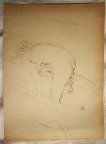
PIERRE BONNARD (1867-1947) Original Lithograph 1/180 by Manuel Broker 1946 BatheLuis Porretta Fine Arts4.3(10)See Sold PriceMar 02, 2024
1867 Map of the Railroads of The State of New YorkRail & Road Auctions4.6(165)See Sold PriceMar 08, 2024
War Diary of 354th Infantry - 89th Division 1919North American Artifact Auctions4.6(182)See Sold PriceApr 20, 2024
[CHICAGO]. Rare Pre-Fire Illinois Map: “Blanchard’s Map of ...Potter & Potter Auctions4.6(539)See Sold PriceMar 07, 2024
William H. Bartlett - Set of 12 views of America - Susquehanna - City of Louisville - ColoradoProverde Auctions4.3(3)See Sold PriceFeb 28, 2024
Francis McNally - Antique Map of Nebraska, Kansas, Dakota, Colorado & MontanaProverde Auctions4.3(3)See Sold PriceFeb 28, 2024
Colorado Vintage Maps & Travel Brochures (76 Pcs)Grant Zahajko Auctions, LLC4.8(1k)See Sold PriceMar 06, 2024


![Hollister's Mines of Colorado with Map, 1867 [169393] (1 of 4)](https://p1.liveauctioneers.com/2699/299063/159201522_1_x.jpg?height=282&quality=70&version=1692045182)


![Blue Line Maps of San Juan Triangle (2) [152842] (1 of 2)](https://p1.liveauctioneers.com/2699/258191/134290997_1_x.jpg?height=282&quality=70&version=1660351799)


![[CHICAGO]. Rare Pre-Fire Illinois Map: “Blanchard’s Map of ... (1 of 2)](https://p1.liveauctioneers.com/928/318880/171361260_1_x.jpg?height=282&quality=70&version=1707501302)