SoldLOT (2) HAND COLORED ENGRAVED MAPSLOT (2) HAND COLORED ENGRAVED MAPS INCLUDING SAINT DOMINQUE AND THE ISLANDS OF GUADELOUPE, SIGNED M. BONNE (FRENCH 18TH CENTURY). PLATES 8 1/4 X 12 1/2" & 9 X 13"; SHEETS 10 X 14 1/2" & 9 3/4 X 15 3/4See Sold Price
SoldMap LotLot (3) framed maps including "Carte De La Baye De Hudson" (sight 9 1/4" x 12 1/4"), "The River St. Laurence" (sight 10" x 14 1/2"), "A Plan of the City and Harbour of Louisburg" (sight 11" x 14 1/2")See Sold Price
Sold(3) ANTIQUE MAPS, BRAZIL, PERU, AMAZON, 18TH C.(lot of 3) Antique maps, including: (1) "Carte de la Terre Ferme du Perou, du Bresil, et du Pays des Amazones," (Peru, Brazil, Amazon), c.1725, Coven & Mortiers Publishers, based on the cartography ofSee Sold Price
SoldM. Bonne Map, Twelve Tribes of IsraelAntique Map. M. Bonne, "Carte Des Douze Tribus d'Israel". Paris, Lattre, n.d. (c. 1780). [framed]. 12 3/4"h x 18 1/4"w=map; 20 1/4"h x 25 1/2"w=frame. Condition: Vertical fold as issued; not examinedSee Sold Price
Lot of 3 copper-engraved maps by BonneTitle: Lot of 3 maps of America by Bonne Author: Bonne, Rigobert Description: Includes: Carte de la Partie Nord, des Etats Unis, de l'Amerique Septentrionale. * Le Nouveau Mexique, avec la Partie SeptSee Sold Price
(3) DECORATIVE FRAMED REPRODUCTION PRINT MAPS(lot of 3) Framed reproduction print maps, 20th c., including: (1) "Romani Imperii Imago," after cartographer Abraham Ortelius, sight: 9.75"h, 13.75"w, overall: 16.75"h, 22.5"w; (1) "Carte de L'Asie MSee Sold Price
Sold[JAPAN]. A lot of 3 maps sold together[JAPAN]. A lot of 3 maps sold together. Engravings on paper, generally fine. Including: Guillaume Sanson. DE EILANDEN VAN JAPAN. 8.5 x 24cm. [1705] ** Jacques Nicolas Bellin. CARTE DES ÃŽLES DU JAPOSee Sold Price
[BONNE] Lot of 7 maps[BONNE] Rigobert Bonne. Engineer and Cartographer. Lot of 7 maps. Including: CARTE DE LA RIVIERE DE COOK, dans la partie N.O.DE L'AMERIQUE. 23.5 x 34 cm. [1780] ** CARTE DE L'ENTREE DE NORTON ET DU DESee Sold Price
Sold2) BONNE MAP FLORIDA, LOUISIANA, GEORGIA, VIRGINIA(lot of 2) Framed maps, including: (1) "Carte de la Louisiane et da la Floride," Rigobert Bonne (French, 1727-1794), showing the southeastern United States, extending from Virginia and Southern IllinoSee Sold Price
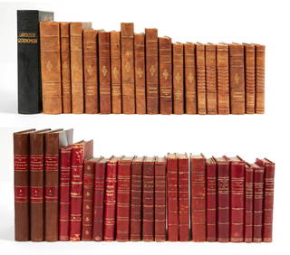
Sold[Prostitution] Lot of 3 WorksLot of 3 works related to prostitution, including: *** RAPPORT SUR LA PROSTITUTION PAR M. DE GOULHOT DE SAINT-GERMAIN... Paris, 1865. 8vo, 31 pp., bound in 1/4 calf with collection of other works, incSee Sold Price
SoldMilbert, M.J. Voyage Pittoresque a L'Ile-de-France auMilbert, M.J. Voyage Pittoresque a L'Ile-de-France au cap de Bonne-Espérance et à l'île de Paris: A. Nepveu, 1812. 3 volumes, including atlas volume, 8vo/4to, half-titles, 45 engraved platesSee Sold Price
SoldLOT (3) HARMONICA INCLUDING M. HOHNERLOT (3) HARMONICA INCLUDING M. HOHNER THE ECHO HARP, VICTORIA TRIMOLA CONCERTA AND M. HOHNER "CHINESE"See Sold Price
SoldMap by M. Bonne, "Carte de la Partie Sud Des EtatsMap, "Carte de la Partie Sud Des Etats Unis De L'Amerique Septentrionale", by M. Bonne, Paris, c. 1780,a rare colored map of the southeastern US printed during the Revolutionary War by America's FrencSee Sold Price
SoldMap LotLot of maps including "CARTE / DE LA / PALESTINE / OF / TERRE SAINTE…1841" (unframed, overall in frame 26 1/2" x 20 1/2"), "CARTE DE L ISLE DE NIEVES" (sight 9" x 6 1/2", overall 16 1/2" x 14"),See Sold Price
SoldArtwork LotArtwork lot, (3) pieces including M. Watt, still life, oil on canvas (23 3/4" x 28"), Steve Abraham, architectural subject, oil on canvas (sight 17 1/2" x 13 1/2"), S. Tepule, seascape, oil on canvasSee Sold Price
SoldGrand Canyon Related TokensAZ - Grand Canyon,Coconino County - Lot of 3 including: M.Buggeln Grand Canyon Hotel, Fred Harvey 30 MNTNCE and The Grand View - Vinegar CollectionSee Sold Price
Sold(3) ANTIQUE MAPS, SPAIN, PORTUGAL, SAXONY, 18TH C.(lot of 3) Antique maps, including: (1) "Saxonie Inferioris Circulus...," c.1730, Georg Matthaus Seutter (German, 1678-1757), hand colored, approx 20.5"h, 23.75"w; (1) "La Catalogna Li Regni Di AragonSee Sold Price
SoldBOX LOT 3 KNIVES INCLUDING U.S. M-4 WITH SHEATHS ANDBOX LOT 3 KNIVES INCLUDING U.S. M-4 WITH SHEATHS AND ONE MARKED VONDERSCHMIDT WITH LEATHER SHEATHSee Sold Price
Sold(3) MAPS: UNITED STATES, MARTHA'S VINEYARD, EUROPE(lot of 3) Framed maps, including: (1) Martha's Vineyard, U.S. Geological Survey, sight: 10.25"h, 14.25"w, overall: 12"h, 16"w, (1) Hungarian map of Europe, sight: 8.25"h, 10"w, overall: 13.25"h, 15"wSee Sold Price
SoldLOT (3) HANDCOLORED ENGRAVED MAPSLOT (3) HANDCOLORED ENGRAVED MAPS INCLUDING BOHEMIA AND MORAVIA (1801), TURKEY/EUROPE, (1801) AND ENGLAND (1811), JOHN CAREY. PLATES 20 1/2 X 23"See Sold Price
(3) ANTIQUE MAPS, GERMANY, 17TH & 18TH C.(lot of 3) Antique maps, including: (1) "Dithmarshen" (Northern Germany), with inset maps of "Brunsbuttel, 1644" and "Meldorpia, 1500," Johannes Mejer (German, c.1606-1674), hand colored, including seSee Sold Price
SoldEngraved Maps, Lot of 3, 18th c.Lot of 3 engraved maps, including: *** AN ACCURATE MAP OF EUROPE. Emanuel Bowen, ca. 1747. Image 7.75" x 6". Hand-colored. Creasing and soiling. *** AN ACCURATE MAP OF ASIA. [Emanuel Bowen, ca. 1747.]See Sold Price
SoldHemisphere maps, James Ferguson(Lot of 3) Associated maps, including two double hemisphere maps, and one single hemisphere map, including a South Pole map, from the Tropic of Capricorn, with the addition of all the New Discoveries,See Sold Price
11: LOT (3) ENGRAVED MAPS, WALES LOT (3) ENGRAVED MAPS, WALES INCLUDING CARDIGAN, RADNOR, FLINT, SIGNED CHRISTOPHORUS SAXTON, 17/18TH CENTURY. PLATES 10 1/2 X 12 1/2See Sold Price
FRANK MARMINGTON c1910 National Gallery Canada Signed Engraving London St. Pauls 20" x 16"Luis Porretta Fine Arts4.3(10)See Sold PriceMar 02, 2024
10 Books including: The Lord of The Rings Part 3, THE RETURN OF THE KING &+Cain Modern Auctions4.4(44)See Sold PriceFeb 28, 2024
10 Books including: 3 Books by J. Krishnamurti & 1 Book by His Holiness the Dalai LamaCain Modern Auctions4.4(44)See Sold PriceFeb 28, 2024
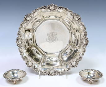
(3) AMERICAN STERLING BOWLS, GORHAM & THEODORE B. STARRAustin Auction Gallery4.7(1.2k)See Sold PriceFeb 25, 2024
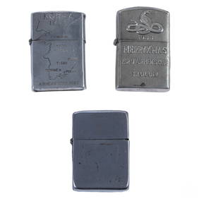
WWII Korea & Vietnam Era Silver Lighters 3pc LOTHill Auction Gallery 4.7(1k)See Sold PriceFeb 28, 2024
[WORLD WAR II]. Archive identified to African American medical officer Captain Clark McRayFreeman's | Hindman4.4(1.6k)See Sold PriceFeb 27, 2024
STAR TREK: THE NEXT GENERATION (1987-1994) - Caldos Colony Weather Control TransparencyPropstore4.2(6)See Sold PriceMar 14, 2024
Carte de la Guinée, contenant…'. Guinea & Cape Verde islands. BONNE 1771 mapJasper524.5(9.8k)See Sold PriceFeb 28, 2024
Carte de la partie septentrionale d'Afrique, ou de la Barbarie… BONNE 1780 mapJasper524.5(9.8k)See Sold PriceFeb 28, 2024
"Map of the Parishes of Iberville Most of West Baton Rouge and Including Parts of the Parishes ofCrescent City Auction Gallery4.3(229)See Sold PriceMar 09, 2024
Lot Of Mid Century Ephemera, Including Maps & 1957 License PlatesClark's Auction Company4.6(433)See Sold PriceMar 03, 2024
Harry Potter Interactive Oak & Hazel Wands Universal StudiosRapid Estate Liquidators and Auction Gallery4.5(1.1k)See Sold PriceFeb 27, 2024
(3) MAGIC LANTERNS, LAPIERRE LAMPASCOPE BOULEAustin Auction Gallery4.7(1.2k)See Sold PriceApr 12, 2024


![[JAPAN]. A lot of 3 maps sold together (1 of 1)](https://p1.liveauctioneers.com/1124/187577/94368871_1_x.jpg?height=282&quality=70&version=1607095126)
![[BONNE] Lot of 7 maps (1 of 1)](https://p1.liveauctioneers.com/1124/187577/94368847_1_x.jpg?height=282&quality=70&version=1607095126)

![[Prostitution] Lot of 3 Works (1 of 9)](https://p1.liveauctioneers.com/3532/146911/74242160_1_x.jpg?height=282&quality=70&version=1564368564)


![[WORLD WAR II]. Archive identified to African American medical officer Captain Clark McRay (1 of 15)](https://p1.liveauctioneers.com/197/319238/171468144_1_x.jpg?height=282&quality=70&version=1707520367)