SoldBellin chart showing Cook's Pacific Voyage 1782Heading: Author: Bellin, Jacques Nicolas Title: Carte de la Partie Septentrionale de la Mer du Sud, Comprise entre la Californie, les Isles Sandwich le Japon et le Detr. de Behring: tirée de la CartSee Sold Price
SoldBellin chart showing Cook's Pacific Voyage 1782Title: Carte de la Partie Septentrionale de la Mer du Sud, Comprise entre la Californie, les Isles Sandwich le Japon et le Detr. de Behring: tirée de la Carte Générale Angloise des découvertes duSee Sold Price
SoldBellin chart showing Cook's Pacific Voyage 1782Title: Carte de la Partie Septentrionale de la Mer du Sud, Comprise entre la Californie, les Isles Sandwich le Japon et le Detr. de Behring: tirée de la Carte Générale Angloise des découvertes duSee Sold Price
SoldWorld.- South Pole.- Cook's Voyages.- , Carte deWorld.- South Pole.- Cook's Voyages.- Carte de l'Hemisphere Austral Montrant les Routes des Navigateurs les Plus Celebres par le Capitaine Jacques Cook, French chart showing James Cook's voyage in theSee Sold Price
SoldCollection of Twelve Maps and Charts, 18th-19th centuryincludes: The World, a small double hemisphere map showing Cook's voyages; Ea-hei-no-maue, North Island, New Zealand (1798, rare); The Coti River, in Borneo; Map of Yucatan; Map of Siam and Cochin ChiSee Sold Price
"Mappe Monde ou Carte Generale de L'Univers... Avec Les"Mappe Monde ou Carte Generale de L'Univers... Avec Les Tours du Monde du Cap.Cook" world map by Matthieu & George Lotter [Augsburg, 1782], showing tracks of Cook's voyages and early appearancSee Sold Price
The Tract of Capt. Cook's Last Voyage, 1799Map: A Chart Showing Capt. Cook's Last Voyage Date: 1799 Maker: J. Low Anderson Size: Octavo, 10.25 inches high x 8.00 inches wide Bearing notation along lower margin of having been engraved for PayneSee Sold Price
New Zealand.- Bonne (Rigobert) Carte de la NouvelleNew Zealand.- Bonne (Rigobert) Carte de la Nouvelle Zéelande, detailed chart of the islands showing the route of Captain Cook's first voyage, engraving with hand-colouring on wove paper, platemarSee Sold Price
SoldZatta (Antonio) Mare del SudZatta (Antonio) Nuove Scoperte fatte nel 1765, 67 e 69 nel Mare del Sud,describing the south-west Pacific voyages of James Cook aboard the Endeavour, in 1770, showing New Zealand and the incomSee Sold Price
Sold-. Chapman (T.) Chart of the Duff's Track in the P-. Chapman (T.) Chart of the Duff's Track in the Pacific Ocean, 1797,charting the first missionary voyage to the South Pacific, showing New Zealand and the incomplete coastline of Australia wiSee Sold Price
Glassbach (Carl Christian) - Charte von einem TheilePacific chart with Australia, showing Tasmania still attached, New Zealand, Mexico and South America, recording the voyages of the Dolphin and the Tamar, under Commodore Byron and Captain Mouat in 176See Sold Price
SoldBowen’s Map of Cook’s Voyages, 1787A new and complete chart of the world displaying the tracks of Capt’n. Cook, and other modern navigators / drawn & engraved by T. Bowen. World map showing the tracks of Endeavour in 1768-1771, ResolSee Sold Price
SoldJournal of Cook's Last Voyage 1781Title: Journal of Captain Cook's Last Voyage, to the Pacific Ocean, on Discovery: Performed in the Years 1776, 1777, 1778, 1779 and 1780. Illustrated with Cuts, and a Chart, Shewing the Tracks of theSee Sold Price
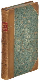
Voyages.- [Rickman (John)] Journal of Captain CookVoyages.- [Rickman (John)] Journal of Captain Cook's last Voyage to the Pacific Ocean,second edition, folding chart and 4 engraved plates, 1 folding, original frontispiece 'Death of Capt.CookSee Sold Price
SoldA mixed group of maps and charts of Asia and theA mixed group of maps and charts of Asia and the PacificIncluding Ceylon, China, Japan and Pacific islands, several from Cook's voyages, engravings, v. s., one with hand-colouring, occasionalSee Sold Price
Bénard (Robert) - Carte de la Côte N.O. dethe northern pacific and the Bering Straits, charting Cook's voyages, engraved chart with hand-colouring, 405 x 665mm., slight wear on old folds, c.1785.See Sold Price
SoldOceania.- CookOceania.- Cook (Captain James) A Voyage to the Pacific Ocean, vol. 2 and 3 only (of 4), first octavo edition, 26 engraved plates and 1 folding chart, some offsetting, occasional spotting, contSee Sold Price
Voyages.- CookVoyages.- Cook (Captain James) A Voyage to the Pacific Ocean, 3 vol. only (lacking atlas vol.), engraved frontispiece portrait and 24 plates and charts, many folding, folding table, offesttingSee Sold Price
SoldCOOK, James, Capt., (1728-1779). A Voyage to the PCOOK, James, Capt., (1728-1779). A Voyage to the Pacific Ocean.... London: Stockdale, etc., 1784. 4 volumes. 8vo (213 x 135 mm). Frontis portrait, folding chart and 49 plates including foldinSee Sold Price
SoldVoyages.- Cook (James) ) [Third Voyage] A Voyage to theVoyages.- Cook (Capt. James) [Third Voyage] A Voyage to the Pacific Ocean, 3 vol. only (of 4, without the Atlas volume), second edition, 24 engraved maps, charts and panoramas, several folding, foldinSee Sold Price
SoldA Voyage to the Pacific Ocean...for making DiscovAuthor: Cook, James and James King Description: Three text volumes and Atlas volume. Text Volumes: [8], xcvi, 421; [12], 549; [12], 558, + [1] ad pp. Illustrated with 24 copper-engraved maps, charts aSee Sold Price
SoldCook (Captain James) [Third Voyage] 1785Cook (Capt. James) [Third Voyage] A Voyage to the Pacific Ocean,3 vol., lacking Atlas vol., titles with engraved medallions, 24 engraved charts and plates, many folding, folding letterpress taSee Sold Price
SoldCook, James and James King.Cook, James and James King. A Voyage to the Pacific Ocean... for making Discoveries in the Northern Hemisphere. London: G. Nicol & T. Cadell, 1784, first edition, 3 volumes 4to, 24 plates and charts oSee Sold Price
SoldCook (Captain James) [Third Voyage] A Voyage to thCook (Captain James) [Third Voyage] A Voyage to the Pacific Ocean,3 vol., lacking Atlas vol., second edition, titles with engraved medallions, 23 engraved charts and plates only (of 24), manySee Sold Price
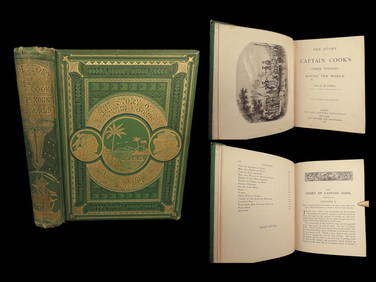
1789 Captain James Cook Life & Voyages Australia New Zealand Hawaii KippisSchilb Antiquarian Rare Books4.8(421)See Sold PriceMar 10, 2024
MISSOURI PACIFIC LINES RAILROAD TIN OVER CARDBOARD CALENDAR.Dan Morphy Auctions4.2(1.3k)See Sold PriceFeb 25, 2024
1871 Captain Cook Voyages Around the World Tahiti Hawaii Exploration AntarcticaSchilb Antiquarian Rare Books4.8(421)See Sold PriceMar 10, 2024
EARLY 18TH C. DUTCH CHART OF PACIFIC OCEAN BY FREDERIK DE WIT (1629-1706) WITH CALIFORNIA AS ANThomaston Place Auction Galleries4.4(386)See Sold PriceFeb 24, 2024
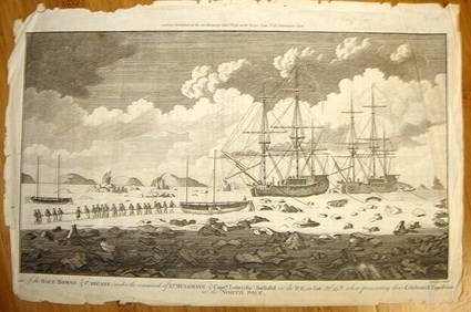
ALEXANDER HOGG ca1790 Engraving Captain Mulgrave Ships Ice Bound Cpt CookLuis Porretta Fine Arts4.3(10)See Sold PriceMar 02, 2024
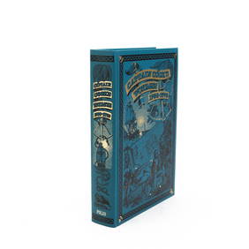
1821 THE (3) VOYAGES of CAPT JAMES COOK VOL. I-VIIJohn McInnis Auctioneers,LLC4.6(502)See Sold PriceFeb 24, 2024
Union Pacific and Chicago, Burlington & Quincy Railroad Dining Car Cook BooksRail & Road Auctions4.6(165)See Sold PriceMar 08, 2024
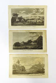
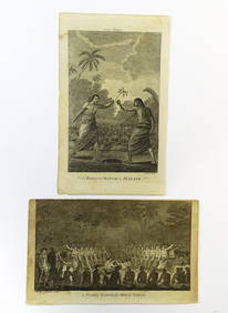
After Beilby & Bewick, 18th century, Engravings, Cook's Voyages - A View of Snug Corner Cover inClaydon Auctioneers Ltd4.3(125)See Sold PriceFeb 26, 2024
After Beilby & Bewick, 18th century, Engravings, Cook's Voyages - An Offering before Captain Cook inClaydon Auctioneers Ltd4.3(125)See Sold PriceFeb 26, 2024
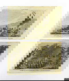
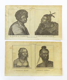
After Beilby & Bewick, 18th century, Engravings, Cook's Voyages - A Woman of Easoo / A Man ofClaydon Auctioneers Ltd4.3(125)See Sold PriceFeb 26, 2024
After Beilby & Bewick, 18th century, Engravings, Cook's Voyages - A Night Dance by Men in Hapae, andClaydon Auctioneers Ltd4.3(125)See Sold PriceFeb 26, 2024
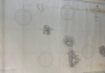
CHART: South Pacific Ocean / SOCIETY ISLANDS - WESTERN GROUP/ HUAHINE TO MAUPITI With theChurchill Galleries3.7(213)See Sold PriceFeb 26, 2024
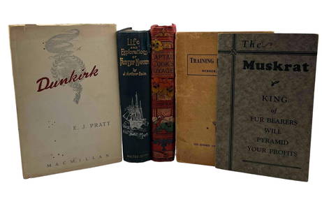
Group Of Military & Exploration Themed BooksClark's Auction Company4.6(433)See Sold PriceMar 03, 2024


![Voyages.- [Rickman (John)] Journal of Captain Cook (1 of 1)](https://p1.liveauctioneers.com/410/34586/14166894_1_x.jpg?height=282&quality=70&version=1352460452)


![Voyages.- Cook (James) ) [Third Voyage] A Voyage to the (1 of 1)](https://p1.liveauctioneers.com/5458/172166/86725111_1_x.jpg?height=282&quality=70&version=1593006460)

![Cook (Captain James) [Third Voyage] 1785 (1 of 1)](https://p1.liveauctioneers.com/410/16922/5635044_1_x.jpg?height=282&quality=70&version=1220603833)


![Cook (Captain James) [Third Voyage] A Voyage to th (1 of 1)](https://p1.liveauctioneers.com/410/21398/7337959_1_x.jpg?height=282&quality=70)