SoldWit (Frederick de) - Nova Africa Descriptio,carte-à-figures with 6 panels of city views above, and 4 panels of various national costume figures at each side, first issued in 1660, but this state with the date removed, engraved map, 440 x 5See Sold Price
SoldDe Wit (Frederick) Asiæ Nova DescriptioDe Wit (Frederick) Asiæ Nova Descriptio,Asia from Turkey to Papua New Guinea, with partial outline of Australia, panels of city views above, regional costume figures to the sides, decorative tSee Sold Price
SoldWit (Frederick de) Magnæ TartariæWit (Frederick de) Magnæ Tartariæ, Magni Mogolis Imperii Japoniæ et Chinæ, Nova Descriptio,north Asia, showingTartary, China and Japan, ornamental title cartouche, engraved map with originalSee Sold Price
FREDERICK DE WIT (DUTCH, 1629-1706) "NOVA TOTIVS/ AFREDERICK DE WIT (DUTCH, 1629-1706) ""NOVA TOTIVS/ AMERICAE/ DESCRIPTIO./ AUCT. F. DE WIT"", 1666 A superb copperplate engraving with original hand color of a map of the Americas; this is the second sSee Sold Price
SoldSinus Gangeticus Vulgo Golfo de Bengala Nova DescriptioFrederick De Wit (1630-1706). Amsterdam: F. De Wit, 1710. Engraved map with original hand color in full. 20 3/4 x 24 3/4 inches sheet. Extremely fine sea chart of the Bay of Bengal, showing Ceylon (SrSee Sold Price
De Wit (Frederick) Magnæ TartariæChina.- De Wit (Frederick) Magnæ Tartariæ, Magni Mogolis Imperii Japonæ et Chinæ, nova descriptio, China and Tartary with Japan, ornamental cartouche, engraved map with full hand-colouring, 43See Sold Price
Soldde Wit map, Magnae Tartariae, c.1680[China/Eastern Asia]. Frederick de Wit. Magnae Tartariae, Magni Mogolis Imperii Japoniae Et Chinae, Nova Descriptio Ex Tabula Ampliss: Viri D.N. Witsen Pro Majori Parte... Double-page engraved map ofSee Sold Price
Sold17th c Map of China- F. De WitChina.- De Wit (Frederick) Magn‘ Tartari‘, Magni Mogolis Imperii Japon‘ et Chin‘, nova descriptio, China and Tartary with Japan, ornamental cartouche, engraved map with hand-coSee Sold Price
SoldMAP - Northeastern Asia. De WitNortheastern Asia. Frederick de Wit, Magnae Tartariae, Magni Mogolis Imperii, Iaponiae et Chinae, Nova Descriptio, 1680 (circa). Hand Color. This handsome map covers the northeastern portion of Asia fSee Sold Price
SoldFrederick de wit World mapCartographer: Frederick de Wit Title: [Map 1] Nova Orbis Tabula, in Lucem Edita [in a set with Map 2] Nova Totius Europae [and Map 3] Nova Totius Asiae [and Map 4] Nova Totius Africa [and Map 5] NovaSee Sold Price
SoldA FREDERICK DE WIT ANTIQUE MAP OF THE AMERICAS "NOVA TOA FREDERICK DE WIT ANTIQUE MAP OF THE AMERICAS ""NOVA TOTIVS/ AMERICAE/ DESCRIPTIO./ AUCT. F. DE WIT"", 1666 (DUTCH, 1629-1706) A superb copperplate engraving with original hand color of a map of theSee Sold Price
Nova Totius Americæ DescriptioAuthor: De Wit, Frederick Description: Copper-engraved map, hand-colored (later?). 43.4x53.9 cm. (17x21½") including vignette images at top and sides. Uncommon, separately published, and quite attracSee Sold Price
SoldFrederick de Wit (1629/1630-1706), NOVA TOTIUSFrederick de Wit (1629/1630-1706)NOVA TOTIUS HUNGARIAE, TRANSILVANIAE, SERVIAE, ROMANIAE, BULGARIAE, WALACHIAE, MOLDAVIAE, SCHLAVONIAE, DALMATIAE, MAXIMAEQ PARTIS DANUBII FLUMINIS DESCRIPTIOhand colouSee Sold Price
SoldDe Wit. Nova et Accurata...Europae. c.1690.[Europe] de Wit, Frederick. “Nova et Accurata Divisa in Regna et Regiones Praecipuas Europae Descriptio.” Amsterdam, c.1690. Engraved map. 22 3/4” x 19 3/4”. Hand-colored. CartSee Sold Price
SoldWestfalen (de Wit): Westphaliae descriptioWestfalen. Nova totius Westphaliae descriptio. Kupferstich mit zwei kleinen Rollwerk-Kartuschen, einer Windrose sowie mit zeitgenöss. Grenzkolorit. 47 x 53,9 cm. Gedruckt tot Amsterdam by Frederick dSee Sold Price
Wit, Frederick de. Nova Orbis Tabula in LucemWit, Frederick de Nova Orbis Tabula in Lucem 1680 Copperplate engraving; coloured Printed area: 57.6 x 48.8 cm; 22.4 x 19.2 in de Wit's striking double hemisphere map of the World is one of the most aSee Sold Price
Wit (Frederick de) Nova Orbis TabulaWit (Frederick de) Nova Orbis Tabula, in lucem edita,engraved map with full orignal hand-colouring, 480 x 570mm., central vertical fold, a little creasing adjacent to fold, uneven damp-staininSee Sold Price
Wit (Frederick de) - Nova Orbis Tabula, In Lucem1st state double-hemisphere world", with 2 polar inset spheres, and elaborate allegorical scenes depicting the four seasons in the corners, engraved map with hand-colouring, 470 x 575mm., repaired splSee Sold Price
SoldWit (Frederick de) - Nova Orbis Tabula, In Lucem2nd state", 2nd plate double-hemisphere world, with 2 polar inset spheres, and elaborate allegorical scenes depicting the four seasons in the corners, with the addition of an engraved border and puttiSee Sold Price
SoldWit (F de) Nova Totius Angliæ, ScotiæWit (Frederick de) Nova Totius Angliæ, Scotiæ, et Hiberniæ Tab.,British Isles, with title in banner form supported by sea creatures, upper right, engraved map with original hand-colouring in oSee Sold Price
SoldEarly map of Africa, Frederick de Wit17th or 18th century. hand colored engraving. H19" W22 7/8"See Sold Price
SoldAmerika (de Wit): Nova totius Americae descriptioAmerika (de Wit) - Nova totius Americae descriptio. Zeitgenöss. grenzkolorierter Kupferstich mit ebenso zeitgenöss. kolorierter figürlicher Kartusche, einer kleinen Allegorie von Meeresgöttern, 6See Sold Price
SoldDE WIT, Frederick. Nova Totius Terrarum Orbis TabuDE WIT, Frederick. Nova Totius Terrarum Orbis Tabula.Amsterdam: c. 1680. Hand-colored double-page engraved map (505 x 580 mm). Condition: browned with old restoration at centerfold. Map of thSee Sold Price
SoldAmerika (de Wit): Nova totius Americae descriptioAmerika (de Wit) - Nova totius Americae descriptio. Grenzkolorierter Kupferstich mit ebenso kolorierter figürlicher Kartusche, einer kleinen Allegorie von Meeresgöttern, 6 kleinen Gesamtansichten voSee Sold Price
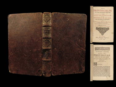
1666 EARLY Blaise PASCAL Provincial Letters Witchcraft Sorcery JESUIT PhilosophySchilb Antiquarian Rare Books4.8(422)See Sold PriceMar 10, 2024
LATE 18TH C. VERY LARGE CHART OF NORTHEAST CANADA BY DES BARRES (1721-1824), 1780, FRAMEDThomaston Place Auction Galleries4.4(389)See Sold PriceFeb 24, 2024
EARLY 18TH C. DUTCH CHART OF PACIFIC OCEAN BY FREDERIK DE WIT (1629-1706) WITH CALIFORNIA AS ANThomaston Place Auction Galleries4.4(389)See Sold PriceFeb 24, 2024
[BASEBALL]. [BISHOP, MAX (1899-1962), association]. KELLY, ...Potter & Potter Auctions4.6(544)See Sold PriceMar 07, 2024
De Jode, Rare, pub. 1593 - Map of Italy (Italiae Totius Orbis olim Domatricis Nova ExactissTrillium Antique Prints & Rare Books4.5(30)See Sold PriceFeb 24, 2024
De Jode, Rare, pub. 1593 - Map of Africa (Africae Vera Forma, et Situs)Trillium Antique Prints & Rare Books4.5(30)See Sold PriceFeb 24, 2024
Map: A 17thC engraved and hand coloured map after Frederik de Wit (1630-1706) titled Nova Persiae,Claydon Auctioneers Ltd4.3(125)See Sold PriceFeb 26, 2024
Unique collection of 18 carte de visites of Queen Victoria’s familyJasper524.5(9.8k)See Sold PriceFeb 27, 2024
Frederic Arthur Bridgman (1847 - 1928) AmericanCoral Gables Auction4.5(511)See Sold PriceFeb 28, 2024


![[BASEBALL]. [BISHOP, MAX (1899-1962), association]. KELLY, ... (1 of 1)](https://p1.liveauctioneers.com/928/318880/171361379_1_x.jpg?height=282&quality=70&version=1707501302)