18th century French map of Pas-de Calais, 1791.18th century French map of Pas-de Calais. Engraved in color, 19-1/4" x 24-3/4" plate size. 1791. Size 29" x 21 -1/2".See Sold Price
Sold1790 French Revolutions de Paris Departments France1790 French Revolutions de Paris Departments France MAPS Pas de Calais Louis Marie Prudhomme was an 18th-century French historian who is known for his satirical and sarcastic articles on the French ReSee Sold Price
Sold18th C 90-Page Manuscript French Ledger JournalTitle: 18Th C 90-Page Manuscript French Ledger Journal 17th Century to early 18th century French Handwritten legal matters in the area of Fremicourt in Nord-Pas-de-Calais. Approximately 90 pages, seveSee Sold Price
17th C Ledger Book Blank 90 Pages France17th Century to early 18th century French Handwritten legal matters in the area of Fremicourt in Nord-Pas-de-Calais. Approximately 90 pages, several being interspersed and blank. Stitched along spine.See Sold Price
Sold1791 French Revolutions de Paris Prudhomme MAPS Illustr1791 French Revolutions de Paris Prudhomme MAPS Illustrated LaFayette France Louis Marie Prudhomme was an 18th-century French historian who is known for his satirical and sarcastic articles on the FreSee Sold Price
de Fer: Antique Map of Saint-Omer, France, 1705Title/Content of Map: 'St. Omer [Saint-Omer]'. Fortified town/city plan. Pas de Calais. Date Printed: 1705 Image Size: Approx 20.0 x 27.5cm, 8 x 10.75 inches (Medium) Type: Early 18th century copperplSee Sold Price
Sold1791 1ed French Revolutions de Paris Prudhomme MAPS1791 1ed French Revolutions de Paris Prudhomme MAPS Illustrated LaFayette France Louis Marie Prudhomme was an 18th-century French historian who is known for his satirical and sarcastic articles on theSee Sold Price
SoldEngraved map, Delahaye, Paris, 18th c.Framed hand-colored engraved map, Carte du Departement de la Seine et de l'Oise, 1791, by Louis Delahaye (French, 18th century), plate: 19.5''h x 19.5''w, overall: 33.5''h x 32''wSee Sold Price
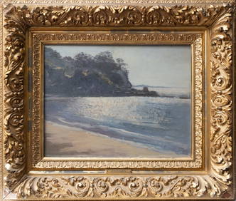
SoldOIL ON CANVAS - FRANCOIS CARBUFRENCH 20th CENTURY "PAS DE CALAIS, FRANCE" 21" X 39"See Sold Price
Sold18th century French Map of the Eastern Seaboard18th century French Map of the Eastern SeaboardPARTIE DE L'AMERIQUE SPTENTRIONALE, QUI COMPREND LE COURS DE L'OHIO, LA NUE ANGLOTERRE, LA NUE YORK, LE NEW JERSEY, LA PENSYLVANIE, LE MARYLAND, LA VIRGISee Sold Price
SoldFRENCH 18TH CENTURY MAP OF RIO DE JANEIROFRENCH 18TH CENTURY MAP OF RIO DE JANEIRO, on laid paper, title in cartouche to upper right corner "Esquisse / DE LA VILLE / ET DU PORT / DE / RIO DE JANEIRO" and lettered within cartouche border "GraSee Sold Price
SoldFRENCH 18TH CENTURY MAP OF RIO DE JANEIROFRENCH 18TH CENTURY MAP OF RIO DE JANEIRO, on laid paper, title in cartouche to upper right corner "Esquisse / DE LA VILLE / ET DU PORT / DE / RIO DE JANEIRO" and lettered within cartouche border "GraSee Sold Price
SoldNew England and Canadian Maps and Prints, a FrenchNew England and Canadian Maps and Prints, a French 18th-century 4to map Carte de la Nouvelle Angleterre, Nouvelle York, Nouvelle Jersey et Pensilvanie, five small black and white bookplate prints of NSee Sold Price
Sold.18th Century French Map of Cuba, Florida and Louisiana21 1/4 x 16 3/4 in. (framed).18th Century French Map of Cuba, Florida and LouisianaGulf of Mexico antique map Golfe du Mexique Zannoni 1762Title: Carte Geo-Hydrographique du Golfe du Mexique et de sesSee Sold Price
SoldLate 18th Century French Map of the Southern UnitedCarte De La Partie Sud Des Etats Unis De L' Amérique De Septentrionale by Rigobert Bonne, circa 1780, copperplate engraving with outline color. Many familiar locales are noted with odd and quaint sSee Sold Price
Sold18TH CENTURY DE l'ISLE FRENCH WORLD MAP18TH CENTURY DE l'ISLE FRENCH WORLD MAP: Circa mid 18th century, double hemisphere map of the world with alternate views in all 4 corners. Top cartouche with banner and motto, partial title ''Mappe-MoSee Sold Price
Sold18th Century French Map of North AmericaL’Amerique Septentrionale. Daniel de la Feuille (1640-1709). Engraved map with hand color in full. Amsterdam, 1702 or 1706. 6 x 8 inches visible, 13 x 14 1/2 inches framed. Nicely colored early 18thSee Sold Price
18th century French map of U.S.,"Carte des Etats-Unis…M. Brion de la Tour…Paris," undated, probably mid-18th century, eastern coast of United States from Florida to New England, hand-colored features, damage and losses to upperSee Sold Price
SoldTwo 18th Century French Maps of Eastern SeaboardTwo 18th Century French Maps of Eastern Seaboard both hand-colored engravings by J. Bellin, Paris, 1757; the first map "Carte De La Nouvelle Angleterre, Nouvelle Yorck et Pensilvanie," shows much of tSee Sold Price
SoldGroup of French Maps Guillaume de l'Isle SansonGroup of four 17th and 18th century French maps. Guillaume Delisle (1675-1726) hand colored engraved map of Picardie, 1748. Two maps by Nicolas Sanson (1600-1677), "Le Roayaume de France" and "GouvernSee Sold Price
Sold18th Century French Maps of the United States andboth by Louis Brion de la Tour, Paris, circa 1790, copperplate engravings with outline color. In modern black wooden frames. DOA 11.5 x 14.5 in. From the Collection of Colette Gaudron, Southeast AsiaSee Sold Price
SoldVuillemin, A 1848 Group of 4 Decorative French MapsOrne, Basses Pyrenees, Puy de Dome, Pas de Calais. Steel Engraved Maps Published 1848, Paris for "La France et ses colonies" by Alexandre Vuillemin & Migeon. Paper Size: 13 x 10 inch (33 x 25cm) GoodSee Sold Price
17th Century Fremicourt Copy Book17th Century French copy book of legal matters in the area of Fremicourt in Nord-Pas-de-Calais. Approximately 90 pages, several being interspersed and blank. Stitched along spine. Measures 6.25 x 8”See Sold Price
Sold(2) 18TH CENTURY FRENCH & GERMAN MAPS(lot of 2) Maps; (1) framed map from the "Atlas Universal" by Gilles Robert de Vaugondy and son (France, c.1723-1786), entitled "Gouvernement General de L'Isle de France, divise par Pays, Par le Sr. RSee Sold Price
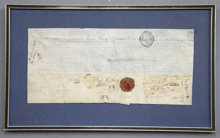
1777 French Military Commission DocumentSchmidt's Antiques Inc. Since 19114.8(431)See Sold PriceMar 02, 2024
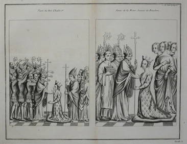
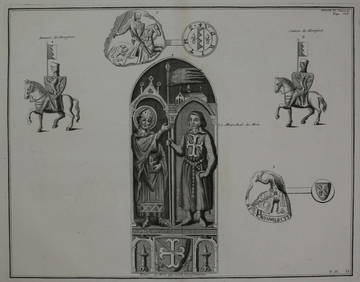
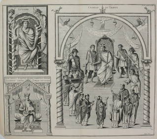
Bernard de Montfaucon c1730 Engraving Les monuments deGlobal Auctions Company4.3(36)See Sold PriceMar 03, 2024
Bernard de Montfaucon c1730 Engraving Les monuments deGlobal Auctions Company4.3(36)See Sold PriceMar 03, 2024
Bernard de Montfaucon c1730 Engraving Les monuments de la monarchie francaiseGlobal Auctions Company4.3(36)See Sold PriceMar 03, 2024
Bernard de Montfaucon c1730 Engraving Les monuments deGlobal Auctions Company4.3(36)See Sold PriceMar 03, 2024
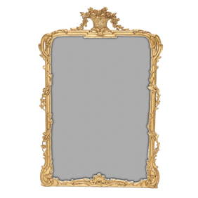
Carver's Guild Panier de Fleur II Rectangular Gold Gilt MirrorNorthgate Gallery, Inc.4.5(36)See Sold PriceMar 02, 2024
1758 MAP PARTIE DE LA MER GLACIALE contenants La Nouvelle Zemble RUSSIA antiqueJasper524.5(9.9k)See Sold PriceFeb 27, 2024
États du Roi de Maroc… d’Alger, Tunis & Tripoli. North Africa. BONNE 1790 mapJasper524.5(9.9k)See Sold PriceFeb 28, 2024
Le Canal de Mosambique, l'Isle de Madagascar… Mozambique. Africa. BONNE 1788 mapJasper524.5(9.9k)See Sold PriceFeb 28, 2024
Royaumes, Etats et Pays de la Haute Guinée. Gulf of Guinea. BONNE 1788 old mapJasper524.5(9.9k)See Sold PriceFeb 28, 2024
Le Canal de Mosambique, l'Isle de Madagascar… Mozambique. Africa. BONNE 1790 mapJasper524.5(9.9k)See Sold PriceFeb 28, 2024
Partie Occidentale de l’Afrique. West Africa coast Canary islands BONNE 1788 mapJasper524.5(9.9k)See Sold PriceFeb 28, 2024
États du Roi de Maroc… d’Alger, Tunis & Tripoli. North Africa. BONNE 1788 mapJasper524.5(9.9k)See Sold PriceFeb 28, 2024
1731 TWO VOLUMES ADVANCED SCIENCE IN FRENCH BY BERNARD FONTENELLENY Elizabeth 4.2(86)See Sold PriceMar 03, 2024
1774: AN ANTIQUE ILLUSTRATED TWO-VOLUME HISTORY OF PERUVIAN DISCOVERY AND CONQUEST WITH MAPNY Elizabeth 4.2(86)See Sold PriceMar 03, 2024
IN FRENCH, L'ELOGE DE LA FOLIE ANCIENT WAS ILLUSTRATED BY ERASMUS IN 1777.NY Elizabeth 4.2(86)See Sold PriceMar 03, 2024
1792 OLD INDIA HISTORY ANTIQUE ILLUSTRATED WITH MAPS OF THE EIGHTEENTH CENTURY IN FRENCHNY Elizabeth 4.2(86)See Sold PriceMar 03, 2024
ENGLISH TRANSLATION OF M.DE SECONDAT BARON DE MONTESQUIEU'S 1793 SPIRIT OF LAWS ARCHAIC LAWNY Elizabeth 4.2(86)See Sold PriceMar 03, 2024
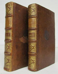
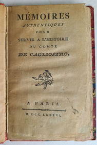
COUNT ALESSANDRO CAGLIOSTRO'S 1786 BIOGRAPHY, AN OLD FRENCH OCCULTNY Elizabeth 4.2(86)See Sold PriceMar 03, 2024
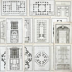
Jean-Francois de Neufforge (1714 - 1791) - Set of 15 Architecture Prints - Development pour unProverde Auctions4.3(3)See Sold PriceFeb 28, 2024
Jean-Francois de Neufforge (1714 - 1791) - Set of 15 Architecture Prints - Plan de l' EdificeProverde Auctions4.3(3)See Sold PriceFeb 28, 2024