SoldCollection of antique maps of Israel [15]. 17th-18thCollection of 15 antique geographic maps of Israel-Palestine. 17th-18th centuries. Various maps printed in various countries. Some maps show distribution of tribes; some are colored. Most written in LSee Sold Price
SoldCollection (12) antique maps by Speede and othersCollection (12) antique maps by Speede and others, 17th/18th c., many provincial maps of Britain, makers include John Norden, John Speede, etc., smallest: 15.5" x 21.5 (sight), largest: 19.75" x 23.75See Sold Price
SoldCollection of Various Regional Maps [10] 17th-18thCollection of [10] antique geographic maps, for the regions of Asia, Albania, Armenia, Saudi Arabia, the Land of Israel and a map of the globe. Various conditions and sizes, overall fine condition.See Sold Price
SoldCollection of maps of the Land of Israel [30] from theA large collection of approximately 30 ancient geographical maps of the Land of Israel. 17th-18th century. Various maps printed in different countries. Some of the maps show the division of tribSee Sold Price
SoldAntique Imari porcelain square dish ex Fould Coll.Antique Imari porcelain square dish ex Fould Coll., 17th/18th c., 15.5" x 15.5" Provenance: Eugene Fould Collection, no. 134See Sold Price
SoldFour 17th-18th C. Maps: Desing, Manesson-MallettCollection of four 17th and 18th European maps, Item 1: P. A. Desings map of the western hemisphere. Hand colored copper engraving published in 1741. 6 3/8" H x 5 3/4" W. Items 2 and 3: Two Manesson-See Sold Price
BATTLES OF KRASNY: 16th, 17th, and 18th November 1812.TITLE/CONTENT OF MAP: 'Battles of Krasnoi, 16th, 17th, and 18th November 1812' DATE PRINTED: 1848 IMAGE SIZE: Approx 15.0 x 21.0cm, 6 x 8.25 inches (Medium) TYPE: Antique hand-coloured engraved map. TSee Sold Price
Sold3 Antique Maps, Wagriae, Westrogothia, ComitatusThree Antique maps. 17th / 18th century. Wagriae (Author Johannes Mejer), Westrogothiae Pars, and Comitatus Bentheim et Steinfurt (cartographer Westenberg). Copperplate engravings in full hand-colorinSee Sold Price
(3) ANTIQUE MAPS, GERMANY, 17TH & 18TH C.(lot of 3) Antique maps, including: (1) "Dithmarshen" (Northern Germany), with inset maps of "Brunsbuttel, 1644" and "Meldorpia, 1500," Johannes Mejer (German, c.1606-1674), hand colored, including seSee Sold Price
SoldCOLLECTION OF ANTIQUE 17TH & 18TH C KEYS ON BOARD(lot of 20) Collection of 17th - 18th century iron keys, mounted on a modern board, loss to board, 12"h, 27.25"w, 8.5lbsSee Sold Price
SoldA Collection of Three Maps, 17th/18th Century, 20A Collection of Three Maps, 17th/18th Century, comprising copper plate engravings by Beaulieu, Kuhn and Rossi. 20 x 25 1/2 inches largest. Property from the Estate of Marcia B. Nachtrieb.See Sold Price
SoldAntique German Maps of Poland, 17th-18th CenturyLot of two antique German maps of Poland:1. Map of Southern Poland centered on Auschwitz: "Ducatus Oswieczensis & Zatoriensis descriptio 1592". Hand-colored copperplate engraving by Matthias Quad, ColSee Sold Price
Sold(2) antique hand-colored maps: Palestine(2) antique hand-colored maps: Palestine, 17th/18th century, Danckerts and another, larger: 21" x 24.5", unframedSee Sold Price
SoldAntique Map of "Morea"Antique Map of "Morea", Probably 17th / 18th c. Titled "Morea Olim Pelo Ponnefus". Matted and mounted under glass in a black molded frame. Crease to center.S: 13"H x 16"W NOTE: Kingdom of the Morea waSee Sold Price
Sold(2) antique hand-colored maps: Africa(2) antique hand-colored maps: Africa, 17th/18th century, incl. Mortier & Covens, larger: 20.75" x 25.5", unframedSee Sold Price
Sold(2) antique hand-colored maps: Austria(2) antique hand-colored maps: Austria, 17th/18th century, incl. Homann and Dewit, larger: 21.5" x 24.5", unframedSee Sold Price
SoldAN ANTIQUE FINLAND MAP, "Finmarchiæ et Laplandiæ,"AN ANTIQUE FINLAND MAP, "Finmarchiæ et Laplandiæ," 17TH/18TH CENTURY, hand colored ink engraving on paper, after Frederik de Wit (Dutch 1630-1706) hand numbered in ink 131 U/R, plate: 19 1/2See Sold Price
Sold(6) antique maps: Turcicum, Belgium, Stiria, etc.(6) antique maps: Turcicum, Belgium, Stiria, etc., 17th/18th century, largest: 21" x 24.5", unframedSee Sold Price
Sold(12) antique maps: North America, Hungary, etc.(12) antique maps: North America, Hungary, etc., 17th/18th century, largest: 11.5" x 17", unframedSee Sold Price
Sold(2) antique maps: Ireland: Ulster and Leinster(2) antique maps: Ireland: Ulster and Leinster, 17th/18th century, by John Speed, larger: 18.75" x 21", unframedSee Sold Price
Sold(2) antique hand-colored maps: Palestine(2) antique hand-colored maps: Palestine, 17th and 18th century, larger: 22.5" x 19.5", unframedSee Sold Price
Sold(6) antique maps: Spain, Germany, Austria, etc.(6) antique maps: Spain, Germany, Austria, etc., 17th/18th century, largest: 21.5" x 26.5", unframedSee Sold Price
Sold(12) antique maps: Chili, Paraguay, Bohemia, etc.(12) antique maps: Chili, Paraguay, Bohemia, etc., 17th/18th century, largest: 22" x 31", unframedSee Sold Price
SoldCollection of Antique Maps of the Land of Israel andCollection of five antique geographic maps of the Land of Israel and the Middle East. Various conditions and sizes. Some are hand-painted. Overall fine condition.See Sold Price
17th / 18th Century West Anatolia Bergama 6 ft 7 in x 2 ft 7 in (2 m x 0.78 m)Nazmiyal Auctions4.4(34)See Sold PriceFeb 25, 2024
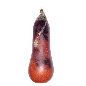
ANTIQUE CHINESE NATURAL GOURD SNUFF BOTTLE SILVERNoble House Collection Gallery4.5(123)See Sold PriceMar 10, 2024
Post Byzantine Bronze Reliquary Cross PendantTimeLine Auctions Ltd.4.6(183)See Sold PriceMar 08, 2024
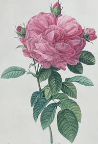
Redoute, Rare, Large Folio - Rose - Rosa Gallica flore giganteoTrillium Antique Prints & Rare Books4.5(32)See Sold PriceFeb 24, 2024
ALBRECHT DURER (1471-1528) "THE LAMENTATION FOR CHRIST".Amelia Jeffers, Auctioneers & Appraisers4.5(120)See Sold PriceMar 07, 2024
TABLE CLOCK: EMPIRE III STYLE IN CARVED BLACK MARBLE AND GOLDEN BRONZE - FRANCE XIX CENTURYABC Gallery4.2(8)See Sold PriceMar 18, 2024
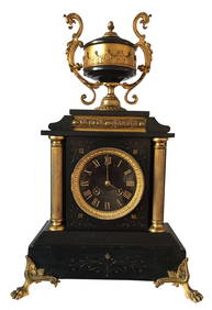
TABLE CLOCK: BRONZE LOUIS XV STYLE, PATINATED CALAMINE SCULPTURE AND WHITE MARBLE PLATES - FRANCEABC Gallery4.2(8)See Sold PriceMar 18, 2024
La Basse-Guinée… Loango, Congo, AngoIa & Benguela Southern Africa BONNE 1790 mapJasper524.5(9.9k)See Sold PriceFeb 28, 2024
La Basse-Guinée… Loango, Congo, AngoIa & Benguela Southern Africa BONNE 1788 mapJasper524.5(9.9k)See Sold PriceFeb 28, 2024
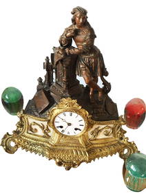
A 17TH/18TH CENTURY SOUTHEAST ASIAN BRONZE FIGURE OF A DRAGON TYPE BEAST. 15 cm x 10 cm.Hannam's Auctioneers Ltd4.3(396)See Sold PriceFeb 27, 2024
A 17TH/18TH CENTURY GLAZED FAIENCE POTTERY VESSEL POSSIBLY A CONTAINER FOR HOLY WATER DEPICTING JESUHannam's Auctioneers Ltd4.3(396)See Sold PriceFeb 27, 2024
ANTIQUE 1686 OPERA OMNIA BY JOHN LIGHTFOOT TELLIMA BOUND FOLIO WITH ISRAEL MAPNY Elizabeth 4.2(86)See Sold PriceMar 03, 2024
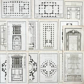
Jean-Francois de Neufforge (1714 - 1791) - Set of 15 Architecture Prints - Development pour unProverde Auctions4.3(3)See Sold PriceFeb 28, 2024
Jean-Francois de Neufforge (1714 - 1791) - Set of 15 Architecture Prints - Plan de l' EdificeProverde Auctions4.3(3)See Sold PriceFeb 28, 2024
Lot of 30 Portraits - Adolph Hendrik - Cornelis van Aerssen - Peder Hanson Resen - Jacob van derProverde Auctions4.3(3)See Sold PriceFeb 28, 2024
[PRIVATE SCOTTISH COLLECTION, BLAIRGOWRIE] GROUP OF FOUR DEHUA 'PRUNUS' TEA WARESLyon & Turnbull4.3(51)See Sold PriceMar 13, 2024
A Chinese blue and white 'chilong' plate, 17th/18th centuryOakridge Auction Gallery4.5(192)See Sold PriceMar 16, 2024
![Collection of antique maps of Israel [15]. 17th-18th First Image](https://p1.liveauctioneers.com/2398/81729/42424775_1_x.jpg?height=282&quality=95&version=1446954509&width=282)
![Collection of antique maps of Israel [15]. 17th-18th (1 of 10)](https://p1.liveauctioneers.com/2398/81729/42424775_1_x.jpg?height=282&quality=70&version=1446954509)
![Collection of antique maps of Israel [15]. 17th-18th First Image](https://p1.liveauctioneers.com/2398/81729/42424775_1_x.jpg?height=282&quality=1&version=1446954509&width=282)

![Collection of Various Regional Maps [10] 17th-18th (1 of 9)](https://p1.liveauctioneers.com/2398/125415/63818048_2_x.jpg?height=282&quality=70&version=1533635458)
![Collection of maps of the Land of Israel [30] from the (1 of 10)](https://p1.liveauctioneers.com/2398/86244/44361873_1_x.jpg?height=282&quality=70&version=1457954143)


![[PRIVATE SCOTTISH COLLECTION, BLAIRGOWRIE] GROUP OF FOUR DEHUA 'PRUNUS' TEA WARES (1 of 1)](https://p1.liveauctioneers.com/94/320325/172143357_1_x.jpg?height=282&quality=70&version=1708531096)


