SoldRare map of Alaska discoveries 1754Heading: Author: Müller, Gerhard Friedrich Title: Nouvelle Cartes Des Decouvertes Faites Par Des Vaisseaux Russes Aux Côtes Inconnues De L'Amerique Septentrionale Avec Les Pais Adiacents. DresséeSee Sold Price
SoldAlaska and the Gold Fields 1st Edition 1897This is a rare first edition of "Alaska and the Klondike Gold Fields" by A.C. Harris and published in 1897. The book provides an early account of the discovery of gold and ensuing population booms thaSee Sold Price
SoldAlaska and the Gold Fields 1st Edition 1897This is a rare first edition of "Alaska and the Klondike Gold Fields" by A.C. Harris and published in 1897. The book provides an early account of the discovery of gold and ensuing population booms thaSee Sold Price
SoldAlaska and the Gold Fields 1st Edition circa 1897This is a rare first edition of "Alaska and the Klondike Gold Fields" by A.C. Harris and published in 1897. The book provides an early account of the discovery of gold and ensuing population booms thaSee Sold Price
SoldRare map of Alaska Gold Rush 1897Heading: (Alaska) Author: Langrehr, Henry C. Title: Alaska and N.W. Territory Gold Fields from San Francisco Place Published: San Francisco Publisher:H.S. Crocker Co. Date Published: 1897See Sold Price
SoldRare French map of Alaska Panhandle 1896Heading: (North America - Pacific Northwest) Author: Title: Amérique du Nord - Côte Ouest. De Dixon Entrance à Cross Sound d'après les Cartes anglaises et américaines Place Published: [Paris, FrSee Sold Price
SoldWith rare Russian map of AlaskaHeading: (Russia, Academy of Science [Ivan Kobelev]) Author: Title: Mesyatsoslov Istorichesko I Geograficheskoi Na 1784 Goda [Historic - Geographic Calender for 1784] Place Published: St. PetersburgSee Sold Price
Sold1754 Antique Map Discoveries of Admiral De FonteAntique map of the Discoveries of Admiral De Fonte and others. 1754. Measures 8 in. x 10 in. Unframed, loose and not mounted or glued down. If lot is absent of a condition report a condition report maSee Sold Price
SoldRare Map New Guinea latest discoveries by DampierTitle: Rare Map New Guinea latest discoveries by Dampier Date/Period: 1744-1748. Materials: Copperplate engraved Dimensions: 16x9 3/4”. Subject. Map of discoveries by Dampier. New Guinea. SurroundSee Sold Price
SoldRare map by Bellin of Russian discoveries in northwestHeading: Author: Bellin, Jacques Nicolas Title: Carte Réduite Des Découvertes Des Russes, Entre l'Asie et l'Amérique... Place Published: Paris Publisher: Date Published: 1764 DescriptiSee Sold Price
SoldRare re-issue of map of Russian discoveries inHeading: Author: Bowles, Carrington Title: Bowles's New Pocket Map of the Discoveries of the Russians on the West Coast of North America Published by the Royal Academy of Sciences at Petersburg PlaceSee Sold Price
SoldRare map of America with inset of Alaska 1818Title: Charte von Nord-America Author:Anonymous Description:Copper-engraved map, hand-colored in outline. 42x29.5 cm. (16½x11½"). Rare and unusual map of North America, published in Prague. The westSee Sold Price
SoldRare map of the World 1738Heading: Author: Overton, Henry and I. Hoole Title: The World: A New and Correct Map laid down & described according to the latest discoveries, to which is added and Explanation of all these Lines (aSee Sold Price
SoldA Complete Chart of the Coast of Asia and AmericaA Complete Chart of the Coast of Asia and America, Robert Seale, Robert 1750. This engaging map was first published in 1692 and seems not to reflect later geographical discoveries. It states "parts unSee Sold Price
SoldA New and Accurate Map of Mexico or New SpainA New and Accurate Map of Mexico or New Spain, Emanuel Bowen, 1740. A handsome map by Emanuel Bowen dated 1740 showing California as a peninsula and giving credit in a text block to the Discoveries ofSee Sold Price
SoldBritish AmericaBritish America, Tallis / Rapkin, 1853. A decorative and detailed Tallis Company map engraved by John Rapkin with illustrations by H. Warren. It includes Canada, Alaska, Greenland and Iceland. VignettSee Sold Price
SoldA map of the world on Mercators Projection. Davis Land. GENTS MAG 1755 oldTITLE/CONTENT OF MAP: 'A map of the World, on Mercators Projection' The map notes the European discovery of Alaska in 1741, and shows in dotted outline a pre-Cook guess at the east coast of Australia.See Sold Price
A map of the world on Mercators Projection. Davis Land. GENTS MAG 1755 oldTITLE/CONTENT OF MAP: 'A map of the World, on Mercators Projection' The map notes the European discovery of Alaska in 1741, and shows in dotted outline a pre-Cook guess at the east coast of Australia.See Sold Price
SoldWiltshireGeorge Bickham, Wiltshire, engraving (hand colored), 1754-1796, from the edition by Laurie & Whittle , 6 x 9 6 x 9See Sold Price
A map of the world on Mercators Projection. Davis Land.TITLE/CONTENT OF MAP: 'A map of the World, on Mercators Projection' The map notes the European discovery of Alaska in 1741, and shows in dotted outline a pre-Cook guess at the east coast of Australia.See Sold Price
SoldCarte des Environs de la Ville de MexicoCarte des Environs de la Ville de Mexico [1754], 7 x 8.5 7 x 8.5See Sold Price
SoldRare 1897 Map of Yukon Gold Belt, by A.L. McDonald &Color lithograph, 14 x 21 in. Map of the Yukon Gold Belt Showing the New Discoveries and the Routes Thereto. (From the Latest Information.) San Francisco: printed by Britton & Rey, published by A. L.See Sold Price
SoldU S Coast Survey 1896 Map. Base Map of AlaskaLithograph Map Published 1896, Washington for "U.S. Coast and Geodetic Survey" Folds as issued. Rare. Paper Size: 18.5 x 11.5 inch (47 x 29cm) Good ConditionSee Sold Price
SoldRare Original 1930s Alaska Steamship Co Map PosterMcCaffrey, Frank. Alaska Steamship Company. Letterpress Print 1936 . Size: 20.4 x 31.1 in. (52 x 79 cm) . Printer: no information . Condition Details: (A-/B+) was folded, on linen, minimal edge tears,See Sold Price
Oregon Short Line RR April 1899 Public TimetableJM Hobby Supply and Railroad Artifact Auctions4.4(126)See Sold PriceFeb 24, 2024
AMBROISE TARDIEU c1822 Napoleonic War Map GermanyLuis Porretta Fine Arts4.3(10)See Sold PriceMar 02, 2024
1822 Rare Map by Ambroise Tardieu Napoleon Caldiero Battle of Vento 17" x 11Luis Porretta Fine Arts4.3(10)See Sold PriceMar 02, 2024
A Set of Treasure and Discovery Island Brochures.Van Eaton Galleries4.6(99)See Sold PriceMar 02, 2024
Arrowsmith & Lewis - Map of PolynesiaTrillium Antique Prints & Rare Books4.5(30)See Sold PriceFeb 24, 2024
Arrowsmith & Lewis - Map of North AmericaTrillium Antique Prints & Rare Books4.5(30)See Sold PriceFeb 24, 2024
Arrowsmith & Lewis - Map of the World on Mercator's ProjectionTrillium Antique Prints & Rare Books4.5(30)See Sold PriceFeb 24, 2024
Arrowsmith & Lewis - Map of LouisianaTrillium Antique Prints & Rare Books4.5(30)See Sold PriceFeb 24, 2024
Arrowsmith & Lewis - Map of the United StatesTrillium Antique Prints & Rare Books4.5(30)See Sold PriceFeb 24, 2024
Catesby, Folio - Tumble-Turds (Dung Beetle) with Canada Lily. Sup-11Trillium Antique Prints & Rare Books4.5(30)See Sold PriceFeb 24, 2024
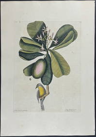
Catesby, Folio - American Goldfinch with Acacia. 1-43Trillium Antique Prints & Rare Books4.5(30)See Sold PriceFeb 24, 2024
Catesby, Folio - Bahama Titmouse with Seven Years Apple. 1-59Trillium Antique Prints & Rare Books4.5(30)See Sold PriceFeb 24, 2024
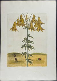
Catesby, Folio - American Partridge with Attamusco Lily. Sup-12Trillium Antique Prints & Rare Books4.5(30)See Sold PriceFeb 24, 2024
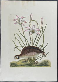
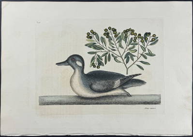
Catesby, Folio - Little Brown Duck with Soap-Wood. 1-98Trillium Antique Prints & Rare Books4.5(30)See Sold PriceFeb 24, 2024
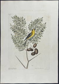
Catesby, Folio - Red Bellied Woodpecker & Hairy Woodpecker with Black Oak. 1-19Trillium Antique Prints & Rare Books4.5(30)See Sold PriceFeb 24, 2024
1774: AN ANTIQUE ILLUSTRATED TWO-VOLUME HISTORY OF PERUVIAN DISCOVERY AND CONQUEST WITH MAPNY Elizabeth 4.3(84)See Sold PriceMar 03, 2024