SoldA printed Speede Map of Devonshire.A printed Speede Map of Devonshire. Detailed 'Devonshire with Excester described and the Armes of such Nobles as have borne the titles of them', 20.5" x 17" (52 cm x 43 cm), framed under glass.See Sold Price
SoldA printed Speede Map of Somersetshire.A printed Speede Map of Somersetshire. Detailed 'Somersetshire described ad in to hundreds devinded with the plott of the famous and moft wholesome waters and citie of the Bathe, by I.S', 22" x 17.5"See Sold Price
Map of Devonshire, 1947Map of Devonshire, 1947Printed by Carles & Read Ltd., dedicated to Sir R. George Stapledon, designed & drawn by Ernest Clegg22.5" x 17.5" — 57.2 x 44.5 cm.Estimate $300/500See Sold Price
SoldCruchley's Reduced Ordnance Survey Map of DevonshireTitle/Content of Map: Cruchley's Reduced Ordnance Survey Map of Devonshire and adjoining areas Date Printed: 1840 ca. Cartographer: CRUCHLEY, C.F. Material/Medium: C.F. CRUCHLEY, mapseller and globe mSee Sold Price
Sold***UNFRAMED ANTIQUARIAN ENGRAVED MAP***UNFRAMED ANTIQUARIAN ENGRAVED MAP| With later hand coloring, depicting the counties of England, engraved by John Speede, printed by Henry Over, approximate size of engraved area 15 1/4" x 20", totaSee Sold Price
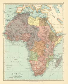
SoldMap of Devonshire & Exeter, [Ca. 1611-1612].Speed, John. Devonshire With Excester described And the Armes of such Nobles as haue borne the titles of them. [Lon]: John Speede, sold by John Sudburi and Goerge Humble, c.1611-1612. Engraved map, unSee Sold Price
SoldA 17th century county map engraving of Devonshire byA 17th century county map engraving of Devonshire by John Speede, 39 x 52 cm, with text verso, framed and glazed on both sidesSee Sold Price
Sold(2) FRAMED ANTIQUARIAN MAP REPRINTSLot of (2) Maps, incl: British Museum reproduction of Saxton's Map of Devonshire, 1575, marked lower left 'British Museum C.7 c.1', printed by Taylowe Limited, 1960, in a gilded wooden frame with mat,See Sold Price
SoldBible, English. The Holy BibleBible, English. The Holy Bible,Authorised version, woodcut titles, the first repaired to verso, Kalender printed in red and black, with the Genealogies and Speede's double-page engraved map (wSee Sold Price
SoldJohn Speede, Norden (John), Hondius (Jodocus), MAP OF EJohn Speede, Norden (John), Hondius (Jodocus), MAP OF ESSEX, sold by Basset and Chiswell, published in 1662, back with printed double page text, 39.5 x 52cm and another map, after Blaeu, Regiones InudSee Sold Price
SoldJohn Speede, Devonshire with Exeter Described, a handJohn Speede, Devonshire with Exeter Described, a hand coloured engraved map, 38 x 51cmSee Sold Price
SoldCARRINGTON BOWLES HORSERACING PRINTThe print "Atlas - the property of His Grace the Duke of Devonshire" features a race horse with rider up. Other horses can be seen racing in the background. It was printed for and sold by Carington BoSee Sold Price
SoldOne of the Earliest Printed Maps of Ukraine,Moses Pitt, c.1680, cartouchee reads 'Typus Generalis Ukrainae sive Palatinatuum Podoliae, Kioviensis...', coper engraving, uncoloured, 58cm x 47cm. 'Note: Pitt's map, first issued by Jan Jansson in aSee Sold Price
SoldJohn Speede - Map of PolandJohn Speede- A Newe Mape of Poland 'Done Into English by J. Speede, bordered with views, arms and regional costumes, engraved map by Dirck Grijp, hand-colored, English text verso, fold reinforced versSee Sold Price
SoldMATTHEUS SEUTTER (German 1678-1757) A PRINTED MAP,MATTHEUS SEUTTER (German 1678-1757) A PRINTED MAP, "Nov. Orbis sive America Septentrionalis...," AUGSBURG, 1760, engraved and published by Tobias Conrad Lotter (German 1717-1777), original hand coloriSee Sold Price
Sold1626 John Speede map Kingdom of Denmark1626 John Speede map of the Kingdom of Denmark- two sheet hand colored map w/ towns, costumes, & types vignettes border, double framed, 16" x 20 1/2"See Sold Price
SoldU.S. COAST SURVEY PRINTED MAPSU.S. COAST SURVEY PRINTED MAPS, H 7"-9 1/2" W 7 1/2"-16":Including map of Sketch E. No. 2, "Showing the Progress of the Survey in the Vicinity of Savannah, Georgia, 1850-1852", measuring H. 8 1/2" x 8See Sold Price
Sold1676 John Speede map of the Invasions of England &1676 John Speede map of the Invasions of England & Ireland 2 sheets 16.5” x 21”See Sold Price
Sold1610 John Speede Map of Cambridgeshire1610 John Speede hand colored two-sheet map of Cambridgeshire, on laid paper, double sided glass frame, sight 14 3/4" x 20 1/4"See Sold Price
Soldca 1616 John Speede map The Province Ulster 2 sheetsca 1616 John Speede map The Province Ulster 2 sheets 16” x 21”See Sold Price
SoldAntique Abraham Ortelius 'Graecia' Printed MapPublished circa 1598 AD A hand-coloured map by the famed Dutch cartographer Abraham Ortelius of 'Graecia' (Greece and Aegean region), from Teatro del Mondo, a miniature atlas; the reverse with text foSee Sold Price
Sold19th c. Religious Printed MapUnusual 19th c. map marked "A Chronological chart of Ancient, Modern and Biblical History. Sychronized by Sebastian C. Adams, Salem Oregon". "Strobridge & Co. Lith. Cincinanati O." Folded in multi-panSee Sold Price
SoldJapanese Edo Period Woodblock Printed Map.Unframed color printed folding map, hand-sewn to silk. 45 1/2" x 50 1/2". Wear from age & use; tape residue and tearing to map present.See Sold Price
SoldAMSTERDAM PRINTED MAP OF BURGUNDYDimensions: (Frame) H 18.5" x W 23" Condition: Wear consistent with age including slight splitting at bottom center seam of map. Some soiling to paper. Frame has minor chips and losses with no paper bSee Sold Price
Collection of Allied Military Silk Printed Maps, WWII Era and LaterMaterial Culture4.6(778)See Sold PriceFeb 29, 2024
Rand McNally Railroad Map Cabinet w/ 21 Railroad MapsRail & Road Auctions4.6(165)See Sold PriceMar 08, 2024
Putnam - First Map of the State of Ohio by Rufus PutnamTrillium Antique Prints & Rare Books4.5(32)See Sold PriceFeb 24, 2024
ALIEN3 (1992) - Hand-drawn Bait and Chase Five Page Storyboard and MapPropstore4.2(6)See Sold PriceMar 13, 2024
NORTH AFRICA BARBARY. Parts of Tripoli (Libya) & Egypt. Tribes. SDUK 1844 mapJasper524.5(9.9k)See Sold PriceFeb 28, 2024
NORTH AFRICA BARBARY. Parts of Tripoli (Libya) & Egypt. Tribes. SDUK 1844 mapJasper524.5(9.9k)See Sold PriceFeb 28, 2024
Africa. French West/Equatorial. Tanganyika Belgian Congo. STANFORD c1925 mapJasper524.5(9.9k)See Sold PriceFeb 28, 2024
NORTH AFRICA BARBARY. Parts of Tripoli (Libya) & Egypt. Tribes. SDUK 1848 mapJasper524.5(9.9k)See Sold PriceFeb 28, 2024
"Map of the Parishes of Iberville Most of West Baton Rouge and Including Parts of the Parishes ofCrescent City Auction Gallery4.3(231)See Sold PriceMar 09, 2024
Monmouth, Illinois Vintage Topography MapRapid Estate Liquidators and Auction Gallery4.5(1.1k)See Sold PriceFeb 28, 2024


![Map of Devonshire & Exeter, [Ca. 1611-1612]. (1 of 1)](https://p1.liveauctioneers.com/179/12922/3750900_1_x.jpg?height=282&quality=70&version=1180274326)