SoldEarly map of Galway dated 1610, "Performet by JohnEarly map of Galway dated 1610, "Performet by John Speede," 15 by 20 inches, framed.See Sold Price
Sold1610 Map of Nottingham by Cartographer John SpeedHistoric Maps 1610 Map "The Countie of Nottingham described..." by Cartographer John Speed & Engraved by Jodocus Hondius 1610-Dated, Hand-Colored English Map titled: "The Countie of Nottingham describSee Sold Price
SoldMap of Yorkshire dated 1610 by John Speed, approx. 16"Map of Yorkshire dated 1610 by John Speed, approx. 16" x 21".See Sold Price
SoldJOHN SPEED MAP OF HUNTINGTON 1610JOHN SPEED MAP OF HUNTINGTON 1610 Framed map of Huntington dated 1610 by John Speed.See Sold Price
SoldSPEED MAP WALESJohn Speed. Merionethshire Described, hand coloured engraved map dated 1610, 39 x 51cmSee Sold Price
SoldJohn Speed map of Surrey dated 1610 15 x 21in. (38 xJohn Speed map of Surrey dated 1610 15 x 21in. (38 x 53cm)See Sold Price
Sold17th century John Speede map of Surrey dated 1610 38cm17th century John Speede map of Surrey dated 1610 38cm by 50 cmSee Sold Price
SoldOriginal John Speed Map 1610 of LondonOriginal John Speed Hand Colored Map of Middlesex London and Westminster. Dated 1610. Map is in excellent condition for something it's age, with only a few fold lines and creases. Professionally mountSee Sold Price
SoldOriginal John Speed Map 1610 of LondonOriginal John Speed Hand Colored Map of Middlesex London and Westminster. Dated 1610. Map is in excellent condition for something it's age, with only a few fold lines and creases. Professionally mountSee Sold Price
SoldOriginal John Speed Map 1610 of LondonOriginal John Speed Hand Colored Map of Middlesex London and Westminster. Dated 1610. Map is in excellent condition for something it's age, with only a few fold lines and creases. Professionally mountSee Sold Price
SoldOriginal John Speed Map 1610 of LondonOriginal John Speed Hand Colored Map of Middlesex London and Westminster. Dated 1610. Map is in excellent condition for something it's age, with only a few fold lines and creases. Professionally mountSee Sold Price
SoldOriginal John Speed Map 1610 of LondonOriginal John Speed Hand Colored Map of Middlesex London and Westminster. Dated 1610. Map is in excellent condition for something it's age, with only a few fold lines and creases. Professionally mountSee Sold Price
SoldOriginal John Speed Map 1610 of LondonOriginal John Speed Hand Colored Map of Middlesex London and Westminster. Dated 1610. Map is in excellent condition for something it's age, with only a few fold lines and creases. Professionally mountSee Sold Price
1610. Map "The Province of ConnaughMap "The Province of Connaugh with The Citie of Galwaye Described" by John Speede. intaglio, handcoloured, framed 38 by 51cm., 15 by 20in. "Performet by John Speede and are to be solde in Popes Head ASee Sold Price
SoldJohn Speed hand tinted map of Surrey dated 1610 blackJohn Speed hand tinted map of Surrey dated 1610 black glazed to reveal textSee Sold Price
SoldUn unframed John Speede County Map engravingAn unframed John Speede County map engraving, Northumberland, dated 1610 and a Robert Morden map of Northumberland, unframed and attached to original pages of text from Camdens Britannia, to/w a volumSee Sold Price
SoldJ. speed map of Northumberland, EnglandCartographer: John Speed Title: Northumberland Subject: Northumberland, England Published: London: Bassett & Chiswell Date: 1676 Description: English county map of Northumberland dated 1610 by Dutch eSee Sold Price
SoldJ. Speed map of Flintshire, WalesCartographer: John Speed Title: Flintshire Subject: Flintshire, Wales Published: London: Sudbury & Humble Date: 1611 Description: Welsh county map of Flintshire dated 1610 by Dutch engraver Jodocus HoSee Sold Price
SoldAn Early Coloured Map of Bohemia, dated 1654, 14.5" xAn Early Coloured Map of Bohemia, dated 1654, 14.5" x 19".See Sold Price
SoldA 17th century John Speede County Map of CambridgshireA 17th century John Speede County Map of Cambridgshire (sic.), dated 1610, 39 x 53 cmSee Sold Price
Sold1610 John Speede Engraved Antique Map Of Surrey17th C John Speede Map Of Surrey. Surrey Described And Divided Into Hundreds' By John Speed Dated 1610. Includes View Of Richmont And Nonsuch Castles. London And The Thames Are Visible In The Upper PaSee Sold Price
MAP, South Carolina, PayneSouth Carolina. John Payne, The State of South Carolina from the Best Authorities, from A New and Complete Universal Geography, 1799 (dated). Hand Color. This early map of the state is finely engravedSee Sold Price
John Speede 'The County of Monmouth' Map,John Speede 'The County of Monmouth' Map, hand coloured, sold by John Sudbury and George Humble, dated 1610, framed and glazed on hogarth frame, 39 x 52cm.See Sold Price
Circle of Christopher Saxton (act.c.1540-1610) British.Circle of Christopher Saxton (act.c.1540-1610) British. "Berkshire", an Outline Coloured Map, bears a Signature 'Saxton Hole' and Dated 1610, 9" x 12.5".See Sold Price
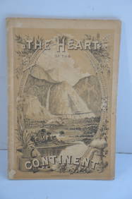
Chicago Burlington and Quincy RR The Heart of the Continent Book-1882JM Hobby Supply and Railroad Artifact Auctions4.4(127)See Sold PriceFeb 24, 2024
17TH C. MAP OF THE BERKSHIRES BY JOHN SPEED, FRAMEDThomaston Place Auction Galleries4.4(393)See Sold PriceFeb 24, 2024
Early 1900's Railway Service Map, Illinois, Ohio, Indiana, Kentucky, TennesseeConnoisseur Auctions3.9(336)See Sold PriceFeb 24, 2024
Catalan school of the early twentieth century. After JOHN EVERETT MILLAIS (United Kingdom, 1829 -Setdart Auction House4(23)See Sold PriceFeb 28, 2024
Thirty Pieces of Lackawanna Railroad Ephemera - Chief Engineer Timebook, Map, Public Timetables,Rail & Road Auctions4.6(165)See Sold PriceMar 07, 2024
Hand Colored Map of the city of Amsterdam 1720Global Auctions Company4.3(36)See Sold PriceMar 03, 2024
Jay-Bee's Vintage Cigar Label Stone Lithograph Art Dated from the late 1800's to early 1900's.North American Artifact Auctions4.7(198)See Sold PriceApr 20, 2024