Vintage Ca. 1940's International Panel Delivery Truck Converted into Stationary Food Truck, WasSwisher Bros. Auction LLC4.4(251)See Sold PriceFeb 25, 2024
Martin Custom Acoustic Guitar 000 Body Style Rosewood with Hard CaseHess Fine Auctions4.5(202)See Sold PriceMar 02, 2024
1968 Gibson LG-0 Acoustic Dreadnought Parlor GuitarHess Fine Auctions4.5(202)See Sold PriceMar 02, 2024
Replica Robinson 1862 Sharps CarbineSchmidt's Antiques Inc. Since 19114.8(431)See Sold PriceMar 02, 2024
PAIR (18th c) OF FLINTLOCK DUELING PISTOLSJohn McInnis Auctioneers,LLC4.6(504)See Sold PriceFeb 24, 2024
PAIR T KETLAND of LONDON .60 CAL FLINTLOCK PISTOLSJohn McInnis Auctioneers,LLC4.6(504)See Sold PriceFeb 25, 2024
Gibson ES335 Semi Hollow Vintage Sunburst Electric Guitar with Certificate of Authenticity Hand MadeHess Fine Auctions4.5(202)See Sold PriceMar 02, 2024
WALT DISNEY WORLD - Figment Animatronic Character Skin from EPCOT's Journey Into ImaginationPropstore4.2(6)See Sold PriceMar 12, 2024
Lot Of 3 Early Large Three-Ring Binders Full Of Thousands Of StampsRbfinearts4.4(575)See Sold PriceFeb 24, 2024
A FINE PERSIAN MALAYER PRAYER RUG WITH CYPRESS C. 1860Soulis Auctions4.8(953)See Sold PriceFeb 24, 2024
Thomas Hart Benton; 20thC. American Regionalist Oil SignedMid-Hudson Auction Galleries4.4(470)See Sold PriceFeb 24, 2024
Fender USA Stratocaster Electric Guitar Classic Candy Red and White Original Stickers with Gig BagHess Fine Auctions4.5(202)See Sold PriceMar 02, 2024
1986 Fender Stratocaster Japan Blue-Green with White Pickguard and Gig Bag JapaneseHess Fine Auctions4.5(202)See Sold PriceMar 02, 2024
SoldBLUNT NORTH AMERICA NAUTICAL CHART, 1828THE NORTH EASTERN COAST of North America from New York to Cape Canso by Edmund Blunt/Published, Sold by E.& G. W. Blunt...New York...Entered according...the 22nd day of July 1828....Additions to 1832See Sold Price
Antique Nautical Chart of San Francisco Harbor, 1885Map: 1885 British Admiralty Chart of San Francisco Harbor -- North America; West Coast; San Francisco Harbour from United States Coast Survey 1877 Date Printed: 1885, London Cartographer: British AdmiSee Sold Price
SoldNautical Chart: N. America inc. Boston, Nova ScotiaNautical Map: A Chart of the Course of North America, from the Strait of Belle Isle to Boston, Banks and Island of Newfoundland, The Gulf and River of St. Lawrence, Nova Scotia, Bay of Fundie &c, ConsSee Sold Price
SoldDufour/Dyonnet: Australia, Oceania with Island InsetsA superbly detailed nautical chart of the Pacific Ocean showing all of Australia, Indonesia, and Japan as well as most of North America and the west coast of South. Includes five insets: southeasternSee Sold Price
SoldFRAMED MONUMENTAL SHIP CHART WITH ROUTE MARKINGS - 1851FRAMED MONUMENTAL SHIP CHART WITH ROUTE MARKINGS - 1851 E.& G.W. Blunt of New York Nautical Chart, North Atlantic Ocean, 1844, updated to 1851, showing several voyages of the 494 ton bark-rigged sailiSee Sold Price
Dufour/Dyonnet: Antique Map of Australia Oceania, 1860sOceanie dressee par A. H. Dufour A superbly detailed nautical chart of the Pacific Ocean showing all of Australia, Indonesia, and Japan as well as most of North America and the west coast of South. InSee Sold Price
Sold(Maps and Charts, North America), Map of the Unite(Maps and Charts, North America), Map of the United States, Willis Thrall, Hartford, [Connecticut], 1828, small schoolhouse map with ebonized wooden rollers, printed in colors and mounted on linen, wiSee Sold Price
SoldBlunt: Antique Blueback Chart of NECoast of USA, 1852Map: North East Coast of North America (Blueback). North East Coast of North America: From the U.S. Coast, Admiralty and Edmund Blunt's Surveys Date Printed: 1852 Cartographer: Blunt, Edmund Size: 56See Sold Price
Original Imray & Son Chart of North Atlantic, 1876Nautical chart of the North Atlantic showing the Eastern United States coast, Caribbean Islands, South America (Venezuela and Brazil), British Possessions (Canada - Gulf of Lawrence, Newfoundland, NovSee Sold Price
SoldOriginal Imray & Son Nautical Chart of North Pacific,Imray & Son map of North Pacific showing the coast of Asia, including China, Manchooria, Nipon, Tungusi, Koriaki and more. The map also features Alaska and islands, British America, and the west coastSee Sold Price
SoldChart of West Coast before Gold RushHeading: Author: Blunt, Edward and George W. Title: West Coast of North America, from the Gulf of Dulce to San Francisco. Spanish and other Authorities Place Published: New York Publisher:E. & G.W. BSee Sold Price
1884 Eldridge Chart of North AmericaOriginal chart of North America detailin Chesapeake Bay from 1884. Condition: with losses. Dimensions: 50" L x 47" H Weight: 9.5lbs *This lot is part of a maritime antique auction of ship models, nautSee Sold Price
Original Imray & Son Chart of North Atlantic, 1876Nautical chart of the North Atlantic showing the Eastern United States coast, Caribbean Islands, South America (Venezuela and Brazil), British Possessions (Canada - Gulf of Lawrence, Newfoundland, NovSee Sold Price
Original Chart of the South Atlantic Ocean, 1864Chart by E. & G.W. Blunt of New York from 1864 of the South Atlantic Ocean, from the Equator 65 south latitude. Showing South Shetland, Falkland, South America, and southern tip of Africa from Congo tSee Sold Price
SoldWeiland: Antique Map of North America, 1828Title/Content of Map: North America, Aleutian Islands insert Date Printed: 1828 Cartographer: F.C. Weiland Material/Medium: Paper Size: 21" x 17 1/2" Hand colored copperplate engraved. Insert shows thSee Sold Price
SoldMap of North America. 1828.Print of steel engraving titled Amerique septentrionale“.Author Fellx Delamarche.Engraved by unknown.From Atlas de la Geographie ancienne du moyen age et moderne“ by Fellx Delamarche. Paris. 1829.See Sold Price
SoldHand Colored North America ChartHand colored copy from an original 1876 Eldridge's chart showing the upper east coast of North America from New Jersey to New Brunswick Canada and an inset panel showing the Chesapeake Bay. Framed.See Sold Price
SoldSamuel Bell Waugh (American, 1814-1885), oil onSamuel Bell Waugh (American, 1814-1885), oil on canvas portrait of John Alexander Brown, Director of the Insurance Company of North America, 1828-1872, retaining a period gold leaf frame, 30'' x 25''.See Sold Price
Blunt: Antique Nautical Chart of Doboy Sound, 1850Map: Doboy Sound and Sapello Island, Georgia Subtitle: Doboy Sound and Sapello Island, Engraved for the American Coast Pilot 16th ed. Creator: Blunt, E and G.W. Year: 1850 Condition: No holes, tears oSee Sold Price
SoldAmerican oil on panel portrait of Isaac PerkinsAmerican oil on panel portrait of Isaac Perkins, Secretary of the Insurance Company of North America, 1819-1828, labeled verso Fogg Art Museum Loan #1187, 26'' x 22 1/2''.See Sold Price
Sold1854 American Coast Pilot by Edmund Blunt includes1854 American Coast Pilot by Edmund Blunt includes nautical chartsSee Sold Price
SoldEldridge chart North America Coast 1882Antique Cape Henry to Cape Sable canvas back chart by Eldrige, as is condition - tears and creasesSee Sold Price
A MAP, NORTH AMERICA, 1825, outline chart of North AmerA MAP, NORTH AMERICA, 1825, outline chart of North America detailing the West Coast and Gulf of Mexico showing approved route across the Pacific. Some soundings in Gulf. Perhaps printed in Spain copieSee Sold Price
Isothermal Chart, North AmericaIsothermal chart, North America, by Issac I. Stevens, 13 1/2" x 27", 20" x 33 3/4" (matt).See Sold Price
LARGE EARLY 18TH C. DUTCH CHART OF UPPER NORTH AMERICA, PIERRE MORTIER (1661-1711), FRAMEDThomaston Place Auction Galleries4.4(389)See Sold PriceFeb 24, 2024
CHART "LONG ISLAND SOUND FROM NEW YORK TO MONTOCK POINT ..." New York, 1830 21" x 77" sight. FramedEldred's4.7(418)See Sold PriceFeb 27, 2024
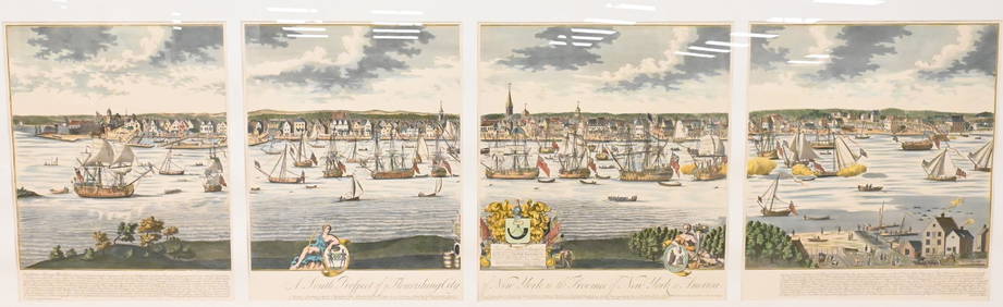
A South Prospect of Ye Flourishing City of New York in the Province of New York, North AmericaNadeau's Auction Gallery4.7(405)See Sold PriceFeb 24, 2024
Map of United States of North America, 1785Antiques Online Auctions4.6(410)See Sold PriceMar 14, 2024