17TH C. ENGLISH LINEAR MAP BY OGILBY, FRAMEDThomaston Place Auction Galleries4.4(386)See Sold PriceFeb 24, 2024
MAP - PIETER SCHENK / VALK / JANSSEN Hand Colored superb Map Central Italy c1702Luis Porretta Fine Arts4.3(10)See Sold PriceMar 02, 2024
OGILVY & BOWEN c1736 Original Map of Oxfordshire Berkshire Etc.Luis Porretta Fine Arts4.3(10)See Sold PriceMar 02, 2024
CHARLES ROLLIN c1828 Ceasar Hand Colored Africa Military MapLuis Porretta Fine Arts4.3(10)See Sold PriceMar 02, 2024
MAP - Dufour, A. H. ( Malte / Brun ) :MAP - ESPAGNE PARTIE SUD DIVISEE EN PROVINCES ANCIENNES ( MAPLuis Porretta Fine Arts4.3(10)See Sold PriceMar 02, 2024
RIGOBERT BONNE c1787 Original Colored Map Germany & Region 15" x 12"Luis Porretta Fine Arts4.3(10)See Sold PriceMar 02, 2024
AMBROISE TARDIEU c1822 Napoleonic War Map GermanyLuis Porretta Fine Arts4.3(10)See Sold PriceMar 02, 2024
MAP - AMBROISE TARDIEU c1822 Napoleonic Miltary Map GermanyLuis Porretta Fine Arts4.3(10)See Sold PriceMar 02, 2024
1822 Rare Map by Ambroise Tardieu Napoleon Caldiero Battle of Vento 17" x 11Luis Porretta Fine Arts4.3(10)See Sold PriceMar 02, 2024
THOMAS MOULE 1837 Colored Map of Warwickshire Framed vgcLuis Porretta Fine Arts4.3(10)See Sold PriceMar 02, 2024
PIETER SCHENK / VALK / JANSSEN Hand Colored Map of Rhodes Greece ca1702 vgcLuis Porretta Fine Arts4.3(10)See Sold PriceMar 02, 2024
STICH & DRUCK c1888 Map Austrian Alps 20" x 16"Luis Porretta Fine Arts4.3(10)See Sold PriceMar 02, 2024
Map of France. Print in 1850.Map of France after the death Chlothaire I in 561 - 613. Print in 1850.Print of steel engraving titled „La France apres la mort clothaire 1er. Indiquant letendue des 4 Royaumes qui se formerent alorSee Sold Price
Map of France. Print in 1850.Print of steel engraving titled „La France sous les enfans de Clovis .Author A. Houze.Engraved by unknown.From the „Atlas Universel Historique et Geographique by A. Houze, Paris. 1850.France officSee Sold Price
Map of France. Print in 1850.Map of France at the beginning of Race 3 in 987 - 996. Print in 1850.Print of steel engraving titled „La France au commencement de la 3 Race Sous le Regne de Hugues Capet 987 a 996 .Author A. Houze.See Sold Price
Map of France. Print in 1850.Map of France at the end of the Reign of S. Louis in 1223 - 1270. Print in 1850.Print of steel engraving titled „La France a la fin du Regne de S. Louis de 1223 a 1270.Author A. Houze.Engraved by unSee Sold Price
Map of France. Print in 1850.Map of France in the time of death of Clovis in 510. Print in 1850.Print of steel engraving titled „La France a la Mort de Clovis en 510 .Author A. Houze.Engraved by unknown.From the „Atlas UniverSee Sold Price
Map of France. Print in 1850.Map of France after the invasion of the barbarians in 481. Print in 1850.Print of steel engraving titled „La France apres linvasion des Barbares immediatement avant le regne de Clovia en 481.AuthorSee Sold Price
Map of France. Print in 1850.Map of France at the end of the second Race in 843 - 987. Print in 1850.Print of steel engraving titled „La France a la fin de la 2 e Race de 843 a 987 .Author A. Houze.Engraved by unknown.From theSee Sold Price
Map of France. Print in 1850.Map of France in the time of death of Louis XIV and after in 1643 -1715. Print in 1850.Print of steel engraving titled „La France a la mort de Louis XIV et apres le trailes DUtrecht et de rasttadt 1See Sold Price
Map of France. Print in 1850.Map of France in the time of death of Louis VII in 1108 - 1180. Print in 1850.Print of steel engraving titled „La France ala mort de Louis VII 1108 a 1180.Author A. Houze.Engraved by unknown.From thSee Sold Price
Map of France. Print in 1850.Map of France at the death of Philip I in 996 - 1108. Print in 1850.Print of steel engraving titled „La France a la mors de Philippe 1er 996 a 1108 .Author A. Houze.Engraved by unknown.From the „ASee Sold Price
Map of France. Print in 1850.Map of France in the time of death of Philippe Auguste in 1180 - 1223. Print in 1850.Print of steel engraving titled „La France ala mort de Philippe Auguste 1180 a 1223.Author A. Houze.Engraved by uSee Sold Price
Map of France in 1350 - 1364. Print in 1850.Print of steel engraving titled „La France apres le traite de Bretigne 1350 a 1364“.Author A. Houze.Engraved by unknown.From the „Atlas Universel Historique et Geographique“ by A. Houze, ParisSee Sold Price
SoldMap of France in 1270 - 1328. Print in 1850.Print of steel engraving titled „La France a la mort de Charles IV Tit le Belt de 1270 a 1328“.Author A. Houze.Engraved by unknown.From the „Atlas Universel Historique et Geographique“ by A. HSee Sold Price
Map of France in 1328 - 1350. Print in 1850.Print of steel engraving titled „La France a la fin du regne de Philippe VI 1328 a 1350.Author A. Houze.Engraved by unknown.From the „Atlas Universel Historique et Geographique by A. Houze, Paris.See Sold Price
Map of France in 1364 - 1380. Print in 1850.Print of steel engraving titled „La France a la fin du Regne de Charles V. 1364 a 1380.Author A. Houze.Engraved by unknown.From the „Atlas Universel Historique et Geographique by A. Houze, Paris.See Sold Price
Map of France in 1350 - 1364. Print in 1850.Print of steel engraving titled „La France apres le traite de Bretigne 1350 a 1364“.Author A. Houze.Engraved by unknown.From the „Atlas Universel Historique et Geographique“ by A. Houze, ParisSee Sold Price
Map of France in 1814 - 1849. Print in 1850.Print of steel engraving titled „La France sous regne de Louis XVIII Charles X et Louis Philippe 1er 1814 a 1849.Author A. Houze.Engraved by unknown.From the „Atlas Universel Historique et GeograpSee Sold Price
Map of French in 1422 - 1461. Print in 1850.Print of steel engraving titled „La France a la fin du regne de Charles VII 1422 - 1461.Author A. Houze.Engraved by unknown.From the „Atlas Universel Historique et Geographique by A. Houze, Paris.See Sold Price
Map of French in 1547 - 1589. Print in 1850.Print of steel engraving titled „La France a la mort de Henri III 1547 a 1589.Author A. Houze.Engraved by unknown.From the „Atlas Universel Historique et Geographique by A. Houze, Paris. 1850.FranSee Sold Price
Map of French in 1483 - 1547. Print in 1850.Print of steel engraving titled „La France a la fin du regne de Francois 1er de 1483 a 1547.Author A. Houze.Engraved by unknown.From the „Atlas Universel Historique et Geographique by A. Houze, PaSee Sold Price
Map of French in 1715 - 1774. Print in 1850.Print of steel engraving titled „La France a la fin du Regne De Loyuis XV de 1715 - 1774.Author A. Houze.Engraved by unknown.From the „Atlas Universel Historique et Geographique by A. Houze, ParisSee Sold Price
Map of French in 1380 - 1422. Print in 1850.Print of steel engraving titled „La France apres la mort de Charles VI 1380 a 1422.Author A. Houze.Engraved by unknown.From the „Atlas Universel Historique et Geographique by A. Houze, Paris. 1850See Sold Price
Map of French in 1589 - 1643. Print in 1850.Print of steel engraving titled „La France a la mort de Louis XIII 1589 - 1643.Author A. Houze.Engraved by unknown.From the „Atlas Universel Historique et Geographique by A. Houze, Paris. 1850.FraSee Sold Price
France (Paris & Cosica), 1850Original engraving by Thomas Cowperthwait from Mitchell’s Universal Atlas, 1850. Features a vignette of Paris & Corsica, including provinces. Dimensions: 14 x 16 inchesSee Sold Price
CLAUDE EDMOND DELBOS (1878-1949) Engraving Meadow Landscape ca1929Luis Porretta Fine Arts4.3(10)See Sold PriceMar 02, 2024
CLAUDE EDMOND DELBOS (1879-1949) Engraving Tree LandscapeLuis Porretta Fine Arts4.3(10)See Sold PriceMar 02, 2024
Honore Daumier France 1808-1879 Lithograph La Bon Argument Ltd Ed 500Global Auctions Company4.3(36)See Sold PriceMar 03, 2024
Honore Daumier France 1808 -1879 Lithograph Physiognomic Le Charivari 1850Global Auctions Company4.3(36)See Sold PriceMar 03, 2024
Duval - Pair: Map of Georgia & Map of Moscow, RussiaTrillium Antique Prints & Rare Books4.5(30)See Sold PriceFeb 24, 2024
Duval - Pair: Map of India & Map of MaldivesTrillium Antique Prints & Rare Books4.5(30)See Sold PriceFeb 24, 2024
D'Entrecasteaux - Australia: Coasts of Van Diemen's Land (New Holland). 9Trillium Antique Prints & Rare Books4.5(30)See Sold PriceFeb 24, 2024
D'Entrecasteaux - Tasmania, Australia: Map of the Northern Portion of Recherche Bay. 5Trillium Antique Prints & Rare Books4.5(30)See Sold PriceFeb 24, 2024
D'Entrecasteaux - Australia: Chart of Van Diemen's Land (New Holland). 3Trillium Antique Prints & Rare Books4.5(30)See Sold PriceFeb 24, 2024
D'Entrecasteaux - Map of Australia (New Holland), New Zealand, and southern Asia and surroundingTrillium Antique Prints & Rare Books4.5(30)See Sold PriceFeb 24, 2024
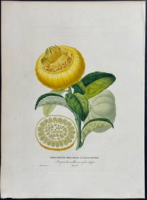
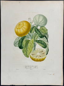
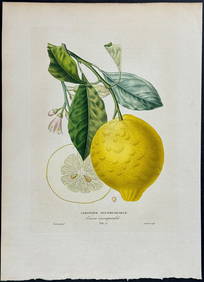
Risso - Lemon or Citrus Fruit. 73Trillium Antique Prints & Rare Books4.5(30)See Sold PriceFeb 24, 2024
Risso - Lemon or Citrus Fruit. 71Trillium Antique Prints & Rare Books4.5(30)See Sold PriceFeb 24, 2024
Bougainville's 1766 circumnavigation. France-Africa-Réunion. GENTS MAG 1774 mapJasper524.5(9.8k)See Sold PriceFeb 28, 2024
Bougainville's 1766 circumnavigation. France-Africa-Réunion. GENTS MAG 1774 mapJasper524.5(9.8k)See Sold PriceFeb 28, 2024
Carte de L'Algérie et de la Régence de Tunis' ANDRIVEAU-GOUJON Algeria 1850 mapJasper524.5(9.8k)See Sold PriceFeb 28, 2024
Jean-Francois de Neufforge (1714 - 1791) - Set of 15 Architecture Prints - Plan de l' EdificeProverde Auctions4.3(3)See Sold PriceFeb 28, 2024
Henri Romagnesi (1912 - 1999) - Set of 8 Mushroom Prints - Rhodophyllus - Entoloma sinuatum -Proverde Auctions4.3(3)See Sold PriceFeb 28, 2024
Henri Romagnesi (1912 - 1999) - Set of 8 Mushroom Prints - Rhodophyllus - Inocybe aeruginascensProverde Auctions4.3(3)See Sold PriceFeb 28, 2024
Antique Map of France, 1703 by Gillaume Del Isle PrintAntiques Online Auctions4.6(407)See Sold PriceMar 14, 2024