SoldMap with Environments of Graz, in 9 Parts, Austria, c.Umgebungen von Graz Austria, c. 1870 9 lithographs in colors on paper, laid down on cloth, folded In original slip case Dimsions of each map: 30.5 x 41.5 cm Dimensions of the slip case: 16 x 11.5 cm GSee Sold Price
Map with Environments of Graz, in 9 Parts, Austria, c.Umgebungen von Graz Austria, c. 1870 9 lithographs in colors on paper, laid down on cloth, folded In original slip case Dimsions of each map: 30.5 x 41.5 cm Dimensions of the slip case: 16 x 11.5 cm GSee Sold Price
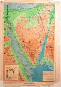
Unknown (20th), Balkan map, 9-part, topography, around 1900, Copper engravingUnknown (20th century): Topographic Map of the Balkans, 9-part, c. 1900, Copper engraving Technique: Copper engraving on Paper Date: c. 1900 Description: Balkan map with Romania and Moldova. The map sSee Sold Price
SoldGuidebook of the Western United States 3 Vol'sGuidebook of the Western United States Parts A & B, Parts C & D and Part E. Interior pages EX/EX+ with fold-out maps. Measures 9-in. x 6-in. Provenance: Bob Borcherdt collection. If lot is absent of aSee Sold Price
SoldAtlases. EWING (T) General Atlas of Modern GeograpyAtlases. EWING (T) General Atlas of Modern Geograpy 1868, 4to; LETTS'S Popular Atlas, c.1900, parts 1 to 9, folio, original wrappers; Century Atlas 1893; BARTHOLOMEW (J) Descriptive Hand Atlas, FullarSee Sold Price
SoldAfter J & C Walker (20th Century) British. "Turkey II,After J & C Walker (20th Century) British. "Turkey II, containing the Northern Part of Greece", Map, Unframed, 9.5" x 13.75", and Three other various Maps "Route of the Israelites", "Bell 'Isle", andSee Sold Price
Koenigreich IllyrienTitle: Koenigreich Illyrien Publication Date: 1847 ca. Cartographer: F. Handtke Publisher: C. FLEMMING Size: 15Height - 11.6Width The Kingdom of Illyria (1816-1849) was part of Austria until 1849, aftSee Sold Price
SoldSibbald, Robert A Collection of Several Treatises inconcerning Scotland, as it was of Old, and also in later Times. Edinburgh: Hamilton and Balfour [&c.], 1739. Folio, 6 parts in one volume, 3 maps (2 folding), 10 plates (9 folding, 1 repaired with sliSee Sold Price
Map of the Marquisate of MoraviaTitle: Map of the Marquisate of Moravia Cartographer: KITCHIN, THOS. Publication Date: 1758-06-01 Publisher: LONDON MAGAZINE Size: 7.25 X 9.3 "with the Northn. Part of the Arch Duchy of Austria. By T.See Sold Price
SoldA Group of Antique Maps"AUSTRIAN DOMINIONS, III., Croatia, Sclavonia, and Dalmatia, with Index Map to the Empire of Austria", "Ancient Italy Part III, and Sicily" both mid 19th century, J and C Walker, published by BaldwinSee Sold Price
A Group of Antique Maps"AUSTRIAN DOMINIONS, III., Croatia, Sclavonia, and Dalmatia, with Index Map to the Empire of Austria", "Ancient Italy Part III, and Sicily" both mid 19th century, J and C Walker, published by BaldwinSee Sold Price
Sold1714 Moll Map of North Africa -- The East Part ofTitle/Content of Map: 1714 Moll Map of North Africa -- The East Part of Barbary Containing Tunis, Tripoli. Barca, Egypt, Nubia, Part of Biledul… Date: 1714 c., London Cartographer: H Moll Size: 6.9See Sold Price
1714 Moll Map of North Africa -- The East Part ofTitle/Content of Map: 1714 Moll Map of North Africa -- The East Part of Barbary Containing Tunis, Tripoli. Barca, Egypt, Nubia, Part of Biledul… Date: 1714 c., London Cartographer: H Moll Size: 6.9See Sold Price
SoldTravelling Level "Brueder Rospini in Graz", c. 185Travelling Level "Brüder Rospini in Graz", c. 1850 = Rospini Brothers in Graz, Austria. Brass, lacquered and burnished. Length of telescope 5 9/10 in., leather-covered wooden case. – An interestingSee Sold Price
1843 Cole Map of Southern Yorkshire -- Yorkshire: PartsTitle/Content of Map: 1843 Cole Map of Southern Yorkshire -- Yorkshire: Parts of the East & West Ridings Date: 1843 c., London Cartographer: G Cole Size: 6.9 X 9 in. This is a very nice county map ofSee Sold Price
Turkey II.Publication Date: 1829-11-01 Title: Turkey II. Cartographer: WALKER, J. & C. Publisher: Baldwin & Cradock/S.D.U.K. Height: 9.3 Width: 13.8 Containing the Northern Part of Greece. Minor waterstain. ResSee Sold Price
SoldTWO MAPS Framed and matted map showing the NortheastTWO MAPS Framed and matted map showing the Northeast part of the "Des Etats Unis", hand-colored, c. 1747, 9" x 13" (sight); Hand-colored map of "North America from the latest Authorities", "publishedSee Sold Price
Sold1795 Map Tennessee with Native American LandmarksMap of the Tennasee Government Formerly Part of North Carolina from the Latest Surveys, 1795," engraved by B. Tanner, published New York, J. Reid, L. Wayland & C. Smith. 9.5" x 17"See Sold Price
Sold1795 Map Tennessee with Native American LandmarksMap of the Tennasee Government Formerly Part of North Carolina from the Latest Surveys, 1795," engraved by B. Tanner, published New York, J. Reid, L. Wayland & C. Smith. 9.5" x 17"See Sold Price
SoldMap of the Northern United StatesCa. late 18th c. engraved map, on laid paper. B. Callender after Abraham Bradley. "Map of the Northern Part of the United States of America." Sheet 16.25" x 9.75". From Morse's Gazetteer of America.See Sold Price
SoldSaudi Arabia.- Murray (John) Map of the Northern PartSaudi Arabia.- Murray (John) Map of the Northern Part of Arabia Shewing the Routes of Mr. G.A. Wallin, engraved map by J. & C. Walker, with hand-colouring, 217 x 250 mm. (8 1/2 x 9 7/8 in), central veSee Sold Price
Sold19th C. New Rail Road & County Map of N. CarolinaPublished 1878-1883 probably by George F. Cram; depicts cities, towns, rivers and railroads; inset continuation "Western Part of N. Carolina."; 11 1/2"W, 9"H--Private collection, Spartanburg, South CaSee Sold Price
1760 Kitchin Map of Moravia: Austria and Czechia -- ATitle: 1760 Kitchin Map of Moravia: Austria and Czechia -- A Map of the Marquisate of Moravia with North.n Part of Arch Duchy of Austria Cartographer: T Kitchin Year / Place: 1760 c., London Map DimenSee Sold Price
1760 Kitchin Map of Moravia: Austria and Czechia -- ATitle: 1760 Kitchin Map of Moravia: Austria and Czechia -- A Map of the Marquisate of Moravia with North.n Part of Arch Duchy of Austria Cartographer: T Kitchin Year / Place: 1760 c., London Map DimenSee Sold Price
18TH C. ANTIQUE MAP: FRENCH & INDIAN WAR, FRAMEDThomaston Place Auction Galleries4.4(394)See Sold PriceFeb 24, 2024
AMBROISE TARDIEU c1822 Napoleonic War Map GermanyLuis Porretta Fine Arts4.3(10)See Sold PriceMar 02, 2024
Ambroise TARDIEU c1822 Map Venice Napoleon Italian Campaign 17" x 11"Luis Porretta Fine Arts4.3(10)See Sold PriceMar 02, 2024
1822 Rare Map by Ambroise Tardieu Napoleon Caldiero Battle of Vento 17" x 11Luis Porretta Fine Arts4.3(10)See Sold PriceMar 02, 2024
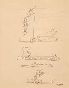
Yves Tanguy (American/French, 1900-1955) - UntitledFreeman's | Hindman4.5(158)See Sold PriceFeb 27, 2024
1816 MAP SOUTHERN PART OF RUSSIA or MUSCOVY in EUROPE copper engraving ANTIQUEJasper524.5(9.9k)See Sold PriceFeb 27, 2024
1816 MAP NORTHERN PART OF RUSSIA or MUSCOVY in EUROPE copper engraving ANTIQUEJasper524.5(9.9k)See Sold PriceFeb 27, 2024
1749 MAP CARTE DE LA TARTARIE ORIENTALE RUSSIA & CHINA antique EASTERN TARTARYJasper524.5(9.9k)See Sold PriceFeb 27, 2024
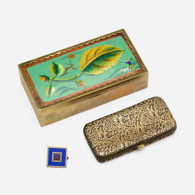
Wiener Werkstatte, Collection of accessoriesToomey & Co. Auctioneers4.7(392)See Sold PriceFeb 29, 2024
Bougainville's 1766 circumnavigation. France-Africa-Réunion. GENTS MAG 1774 mapJasper524.5(9.9k)See Sold PriceFeb 28, 2024
A MONUMENTAL SILVER TORAH SHIELD. Vienna, Austria, c.1880. In cartouche outline. The border isJ. Greenstein & Co., Inc.4.2(55)See Sold PriceApr 16, 2024