SoldTwo local hand drawn and colored survey maps (paper onTwo local hand drawn and colored survey maps (paper on canvas) of farms in the town of Clinton, Dutchess County NY. Includes Levi Van Vliet Farm in very good condition having minor tears on right andSee Sold Price
SoldHistorically important collection of approximately 40Historically important collection of approximately 40 local, mostly hand drawn (some hand colored), land deeds, survey maps, architectural drawings from the Fishkill area of Dutchess County NY - datinSee Sold Price
SoldTWO ANTIQUE ANTEBELLUM MAPS, "Map of Texas,"TWO ANTIQUE ANTEBELLUM MAPS, "Map of Texas," WOLFENBUTTEL, GERMANY, 1851, two hand colored lithographs on paper, one with pencil inscription at distance chart, "Compiled from surveys at the Land OfficSee Sold Price
SoldTWO EARLY ROLL-UP MAPS OF PALESTINA, DAMASCO &GOLGOTA (CALVARY), 19TH OR 18TH C, HAND DRAWN AND HAND COLORED, PAPER MOUNTED ON HEAVY CANVAS, 23 3/4" X 18" AND 24" X 18". 1 MAP SHOWS CREASES, MINOR STAINING, 1 SMALL TEAR.See Sold Price
Rare pocket map of U.S. 1825Title: Map of the United States Drawn from the most approved Surveys Author: Anonymous Description: Copper-engraved map on banknote paper, hand-colored. 41x51 cm. (16x20"); folding into thin morocco cSee Sold Price
SoldEMANUEL BOWEN (BRITISH, 1720-1767) MAP OF THE SOUTHEASTEMANUEL BOWEN (BRITISH, 1720-1767) MAP OF THE SOUTHEAST hand-colored engraving on laid paper, A New and Accurate Map of the Provinces of North & South Carolina, Georgia, &c. Drawn from late Surveys anSee Sold Price
John Speed (England, 1552-1629), two hand-colored mapsJohn Speed (England, 1552-1629), two hand-colored maps on paper: one of Northumberland with town planning, royal arms, and Roman sculptures, plate mark visible on top edge; the other a map of ShropshiSee Sold Price
SoldLarge hand drawn and hand colored survey map entitledLarge hand drawn and hand colored survey map entitled "Map of Sections Nos. 18, 19, 20, 21, 22. / Rondout & Oswego Railroad / A. M. Cady Chief Engineer / Surveyed & Drawn by J.P. Gould" - Includes pulSee Sold Price
SoldEarly hand drawn and hand colored land survey map ofEarly hand drawn and hand colored land survey map of upstate NY, probably Albany area, with settlement dates listed between 1802 and 1857 - family names include Sybrant VanShiack, John Ehle, David ArcSee Sold Price
SoldAn original hand drawn and colored Albany County NYAn original hand drawn and colored Albany County NY cemetery survey map entitled "A Map of Grove Cemetery" signed in pen and ink "J.T. Nichols, Designer / Coeymans N.Y. Oct 31, 1851" (Albany County).See Sold Price
SoldFOLK ART MAPFOLK ART MAP; Hand-drawn and hand-colored map on linen backed paper depicting the Eastern coast of the United States (framed); Signed Nancy Whitlocke 1829; 24'' x 28''See Sold Price
SoldEarly 19th Century Map of VermontHAND DRAWN, COLORED MAP OF VERMONT BY ESTHER CONKEY OF ORWELL OCT 22 1825 ON PAPER 21"X17" LINEN BACKED TORN THRU CENTER OF MAP WITH SOME LOSSES, TAPE RESIDUE,TONING AND SPOTTING - IMPERFECTIONSee Sold Price
2 18TH C. BONNE MAPS OF THE SOUTH ATLANTIC ISLANDSTwo hand colored maps of the South Atlantic Islands, comprising Rigobert Bonne (French 1727-1794) "Isles Maidenland, de Hawkins, et le Detroit De Fakland...", circa 1787, etching on paper showing CommSee Sold Price
SoldA lot of two early hand colored maps Ortelius and Saxton2 (Two) early maps, the first of the Azores by Ortelius, 1584, hand colored engraving on laid paper, verso with printed description, dimensions 18.5in x 23.25in, the other of Huntingdon by Saxton, 163See Sold Price
Sold1856 Hand drawn land survey map Herrin Family EdgefieldFramed hand drawn land survey map involving lands belonging to the Herrin family of Edgefield District SC. Other names mentioned include J. Herrin, Margaret Herrin, William Daniel, and William Mobley.See Sold Price
Hand Drawn Utah State Land Patent Maps #597318.5" x 11" hand drawn and colored map of a Utah land patent showing Sanpete Co. and Salt Co. land State: Utah City: Salt lake Date: c1918See Sold Price
SoldManuscript in French, Cosmography, Astronomy.Manuscript in French, Cosmography, Astronomy. Traité de la Sphere. Quarto format manuscript on paper, presented in two parts, 101 numbered pages of text and twenty-two hand-drawn and colored foldSee Sold Price
Sold1610 John Speede Map of Cambridgeshire1610 John Speede hand colored two-sheet map of Cambridgeshire, on laid paper, double sided glass frame, sight 14 3/4" x 20 1/4"See Sold Price
SoldTwo large folio bindings containing original hand drawnTwo large folio bindings containing original hand drawn and water colored railroad maps: 1) "New York Kingston & Syracuse Railroad / Right of Way Map From Deans to Oneonta" - PAGE SIZE 30" X 21" - 22See Sold Price
SoldTWO 16TH C. MAPS, 1 INDIA & PAKISTAN & 1 IBERIAGroup of two hand colored Lorenz Fries (German 1485-1532), early 1500s etching on paper maps comprising, one of India, Afghanistan and Pakistan and one of the Iberian Peninsula, unframed. Provenance:See Sold Price
SoldTwo Hand-Drawn 19th Century TennesseeMaps by Anne S. Wetherell, most likely drawn as a schoolgirl exercise, both are hand-colored outline on paper: one signed verso "A. S. Wetherell/April 1, 1830” with notes from instructor “Bad branSee Sold Price
SoldMap of the State of North Carolina[with Portions of Adjoining States] by G.W. & C.B. Colton, 1866, two folding hand colored lithographed maps with Colton's usual decorative border, each picturing one half of the state, all contained iSee Sold Price
1828 HAND DRAWN MAP BY THOMPSONHand drawn and colored wall map signed PROJECTED BY BODICEA THOMPSON 1828 showing the Western and Eastern world hemispheres with lower calendar keyed to astrological signs. Lacquered paper map mountedSee Sold Price
Sold1833 Davenport Gazetteer of N. America w/foldout mapsA New Gazetteer or Geographical Dictionary of North America and the West Indies, etc. Original full calf. Gilt-decorated spine with label. Illustrated with two fully hand-colored, foldout maps and manSee Sold Price
MARTINET / DE VRIES Catechism of Nature 4 Vol. Set c1788 Engravings Rare!Luis Porretta Fine Arts4.3(10)See Sold PriceMar 02, 2024
CHARLES ROLLIN c1828 Ceasar Hand Colored Africa Military MapLuis Porretta Fine Arts4.3(10)See Sold PriceMar 02, 2024
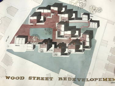
2 Hand Drawn Development Architecture PlansThe Benefit Shop Foundation Inc.4.3(2.9k)See Sold PriceFeb 28, 2024
Set 4 Vtg Hand Drawn & Colored Architecture PlansThe Benefit Shop Foundation Inc.4.3(2.9k)See Sold PriceFeb 28, 2024
Hand Colored Map of the city of Amsterdam 1720Global Auctions Company4.3(36)See Sold PriceMar 03, 2024
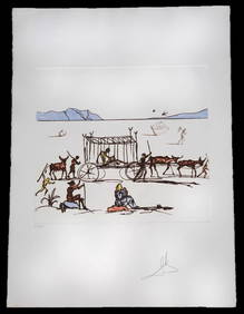
Salvador Dali "Judgement" Color Etching & AquatintNapoleon's Fine Art4.4(75)See Sold PriceFeb 25, 2024
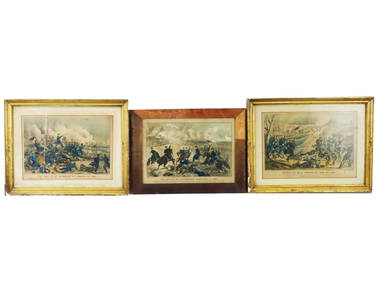
ANTIQUE AMERICAN CIVIL WAR HAND COLORED LITHOGRAPHSAntique Arena Inc.4.5(878)See Sold PriceFeb 24, 2024
Strickler, Rare - San Francisco, CaliforniaTrillium Antique Prints & Rare Books4.5(32)See Sold PriceFeb 24, 2024
Two Hand-Colored 19th Century Maps of New Orleans and Louisiana, Larger- H.- 12 1/2 in., W.- 15 1/2Crescent City Auction Gallery4.3(231)See Sold PriceMar 08, 2024
Galliae Regionis Nova Descriptio Hand Colored Map of France on Laid Paper, Ca. 16th Century, H 10" WDuMouchelles4.6(830)See Sold PriceMar 15, 2024