Map of North and South Carolina
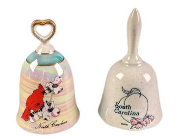
Portfolio of 15 County Maps by Robert Morden (English 1650-1703)Feb 24, 2024[ENSLAVEMENT & ABOLITION]. Letter from a southern slave trader describing the transportation ofFeb 27, 2024Carey, pub. 1796 - Map of The State of South CarolinaFeb 24, 2024Carey, pub. 1796 - Map of the Tennassee State formerly part of North Carolina (Tennessee)Feb 24, 2024Map: An 18thC engraved and hand coloured map of North America and South America, titled DeFeb 26, 20241822 MAP of NORTH & SOUTH AMERICA GEOGRAPHICAL STATISTICAL HISTORICAL antiqueFeb 27, 2024Mexico, Central America and the West IndiesFeb 27, 2024Slave owner avoids risk" of slave stealing"Mar 07, 2024Narrative of the conjoined McKoy twinsMar 07, 2024Zane Grey crashes as authorMar 07, 2024Letter from W. Wilson to his wife, 1892Mar 07, 2024De l'Isle's influential map of Americas 1722Mar 07, 2024The Americas in 1596Mar 07, 2024Morden's America with California an islandMar 07, 2024Americas with Californa an island 1705Mar 07, 2024Weigel map of Americas Calif. an islandMar 07, 2024Philips' Atlas of Counties of EnglandMar 07, 2024Large map of the Americas 1794Mar 07, 2024Blackie (Pub) 1882 Pair of Folio Maps. Italy - North & SouthMar 01, 2024Vintage North And South Carolina Souvenir Porcelain BellsMar 02, 2024JASPER JOHNS OIL ON CANVAS ABSTRACTMar 06, 2024MAP, World, BaschlinMar 12, 2024MAP, Eastern US, StockdaleMar 12, 2024MAP, England, JaillotMar 12, 2024 


![[ENSLAVEMENT & ABOLITION]. Letter from a southern slave trader describing the transportation of (1 of 3)](https://p1.liveauctioneers.com/197/319238/171468031_1_x.jpg?height=282&quality=70&version=1707520367)