SoldMap of The State of New Hampshire. compiled chieflMap of The State of New Hampshire. compiled chiefly from Actual Surveys by Samuel Lewis. dated 1794. V shaped tear on center fold along right border, not affecting map. browning. ss: 17 1/2" x 11"wSee Sold Price
Very scarce 1813 map of New Hampshire by M. CareyMathew Carey's “The State of New Hampshire compiled chiefly from actual surveys by Samuel Lewis in 1813” which first appeared in his American Atlas. The map is minutely detailed, showing iSee Sold Price
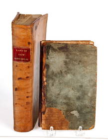
SoldAtlas of the State of New Hampshire. 1892.[Atlas/New Hampshire] Town and City Atlas of the State of New Hampshire. Compiled from Government Surveys, County Records and Personal Investigations. D.H. Hurd & Co., Boston, 1892. Large Folio (17&frSee Sold Price
SoldMAP, New England - US, FinleyNew England - United States. Anthony Finley, Map of Maine New Hampshire and Vermont, Compiled from the Latest Authorities, 1826 (dated). Hand Color. This folding version of Finley's atlas map delineatSee Sold Price
SoldMAP OF THE STATE OF NEW HAMPSHIRE, PUB HAGSTROM CO. NY.Paper wall map on canvas. Drawn by Elizabeth Shurtleff & Helen F. McMillin. Bold color lithography, Pub. By Hagstrom Co. NY. 33” x 24”See Sold Price
SoldMap of the States of New Hampshire & VermontCirca 1796 Antique Map Title: "Map of the States of New Hampshire and Vermont". Citation: by J. Denison. Amos Doolittle, Sculp. Approximate size: 10-3/8" x 8-3/8". Please note that this lot has a confSee Sold Price
SoldTownship Map of the States of New Hampshire and VeTownship Map of the States of New Hampshire and Vermont, 1873 G. W. & C. B. Colton & Co., New York, 1873. 16mo. Map unfolds to 23 1/2" x 28". Hand-colored, folding pocket map. A few small, mostly pinhSee Sold Price
Colton, Township Map of the States of New Hampshire andCOLTON, G. W. – COLTON, C. B. Township Map of the States of New Hampshire and Vermont. New York: G. W. & C. B. Colton & Co., 1891. Lithographed, original hand color in full. 29 x 23 ½ inches (unfraSee Sold Price
Map of the State of New Jersey, 1814Map: The State of New Jersey, Compiled from the Most Authentic Information Cartographer: M Carey Date: 1814 Origin: Philadelphia Size: 18.5 x 13 inches A rather attractive topographical map of New JerSee Sold Price
SoldThe State of New York, Compiled from the most AuthenticTitle/Content of Map: The State of New York, Compiled from the most Authentic Information. 1796. Cartographer: D. Martin Height (inches): 15.25 Width (inches): 18Year: 1796 Martin Sculpt.Curious earlySee Sold Price
SoldThree maps, colored engraved maps, the State ofThree maps, colored engraved maps, the State of Massachusetts, New Hampshire by Samuel Lewis 1813, Rhode Island by Caleb Harris. sight size: 14 1/4" x 9 3/4" to 14" x 19 1/4".See Sold Price
SoldMapMap of states of N.Y., New Hampshire, Vermont, Massachusetts, Rhode Island And Connecticut. Sight 13 1/2" x 21".See Sold Price
SoldFramed map of the state of New Jersey compiled from theFramed map of the state of New Jersey compiled from the most authentic information, compiled by Samuel Lewis. From Carey's General Atlas, 1814. The first atlas made in the United States to employ stanSee Sold Price
SoldMap of The State of New Jersey. compiled by SamuelMap of The State of New Jersey. compiled by Samuel Lewis. "Engraved for Carey's American Edition of Guthrie's Geography improved" appx. 1" tear along edge of center fold. browning. ss: 18"h x 12"wSee Sold Price
New Hampshire antique state map. Counties. BUCHON, 1825TITLE/CONTENT OF MAP: 'Carte géographique, statistique et historique de New Hampshire' DATE PRINTED: 1825 IMAGE SIZE: Approx 49.5 x 64.5cm, 19.5 x 25.5 inches (Large); Please note that this is a foldSee Sold Price
The Tourist's Map of the State of New York, 1828Map: The Tourist's Map of the State of New York Compiled from the Latest Authorities in the Surveyor General's Office Cartographer: W. Williams Publishing: Utica, 1828 Size: 19.5 x 20.5 inches Scare pSee Sold Price
Williams: Antique Pocket Map on New York State, 1828Title: 1828 Williams Pocket Map on New York State -- The Tourist's Map of the State of New York Compiled from the Latest Authorities in the Surveyor General's Office Cartographer: W. Williams Year / PSee Sold Price
SoldThomas, Cowpwerthwait: Antique Map of New York, 1854Title/Content of Map: 1854 Thomas, Cowpwerthwait Map of New York State -- Map of the State of New York Compiled from the Latest Authorities Date Printed: 1854 Philadelphia Cartographer: Thomas, CowperSee Sold Price
SoldWilliams: Antique Pocket Map on New York State, 1828Map: 1828 Williams Pocket Map on New York State -- The Tourist's Map of the State of New York Compiled from the Latest Authorities in the Surveyor General's Office Cartographer: W. Williams Year / PlaSee Sold Price
SoldMap Of The State Of New York..., 1808.[United States/New York]. Map Of The State Of New York Compiled from the Latest Authorities including the Turnpike Roads now granted as also the principal common roads connected therewith…By Wm [WilSee Sold Price
Sold4th Mitchell edn of D. H. Vance's map of New YorkHeading: Author: Mitchell, S. Augustus Title: Map of the State of New York Compiled from the Latest Authorities Place Published: Philadelphia Publisher:S. Augustus Mitchell Date Published: 1See Sold Price
1833 Pocket Map of New YorkPocket Map of New York 1833, MAP OF THE STATE OF NEW YORK COMPILED FROM THE LATEST AUTHORITIES by Samuel Augustus Mitchell, Choice Extremely Fine. 17" x 21.25" (folds into original, gilt-lettered greeSee Sold Price
Map Tourist State New York Pocket Folding 1829 Co''Tourist's Map of the State of New York, Compiled From the Latest Authorities in the Surveyor General's Office.'' William Williams: Utica: 1829. Engraved by Balch, Stiles & Company. Folding pocket maSee Sold Price
Map Tourist State New York Pocket Folding 1829 Color''Tourist's Map of the State of New York, Compiled From the Latest Authorities in the Surveyor General's Office.'' William Williams: Utica: 1829. Engraved by Balch, Stiles & Company. Folding pocket maSee Sold Price
1892 Adams and Bowles New Road Map of the State of New YorkJM Hobby Supply and Railroad Artifact Auctions4.4(127)See Sold PriceFeb 24, 2024
Crams Railroad Map of New York-1881JM Hobby Supply and Railroad Artifact Auctions4.4(127)See Sold PriceFeb 24, 2024
EARLY CONSTITUTION & DECLARATION of INDEPENDENCEJohn McInnis Auctioneers,LLC4.5(505)See Sold PriceFeb 24, 2024
Vintage County Map Of NY State Plate EngravingThe Benefit Shop Foundation Inc.4.3(3k)See Sold PriceFeb 28, 2024
1867 Map of the Railroads of The State of New YorkRail & Road Auctions4.6(165)See Sold PriceMar 08, 2024
Chinese Enameled Copper Snuff Box w/ Ivory FiguresArtemis Fine Arts4.8(1.4k)See Sold PriceFeb 26, 2024
2000 20 piece United States Mint Set with Sacagawea DollarKey Date Coins4.4(1.4k)See Sold PriceFeb 23, 2024