SoldGray's Aero View Map of the Panama CanalModeled and Copyrighted: C.P. Gray, Mapmaker. New York. Plaster. Condition: Some chips.; 20" x 60"See Sold Price
Gray's Aero View of the Panama CanalTitle/Content of Map: Gray's Aero View of the Panama Canal Cartographer: GRAY, C. P. Date: c1912 Publisher: C.P. GRAY, MAP MAKER Size: 5Height - 14Width Not an aerial view but a small relief map of thSee Sold Price
Gray's Aero View of the Panama CanalTitle: Gray's Aero View of the Panama Canal Publication Date: 1912 ca. Cartographer: GRAY, C. P. Publisher: C.P. GRAY, MAP MAKER Size: 5X14 Not an aerial view but a small relief map of the canal. ShowSee Sold Price
SoldMAPGRAY'S AERO VEIW OF THE PANAMA CANAL 1912. 14 INCHES X 5 INCHES. All property is sold "AS IS", "WHERE IS", and ALL SALES ARE FINAL. There are NO REFUNDS, NO EXCHANGES. ALL ARTWORK, PAINTINGS, ENGRAVINSee Sold Price
Sold"AERONAUTICAL VIEW OF PANAMA CANAL" PROMOTIONAL MAP FOL4-1/8x13.75" cardboard folder w/cloth binding along top opens to reveal interesting raised relief map of the Panama Canal, which was not yet completed at the time this map was produced, showing the coSee Sold Price
SoldBird's Eye View of the Panama CanalHeading: (Panama Canal) Author: Title: Bird's Eye View of the Panama Canal and Map of Panama Place Published: Panama City Publisher:I.L. Maduro, Jr. Date Published: No date DescriptionSee Sold Price
SoldPanama Canal, 'Bird's Eye View of the Panama CanalPanama Canal, 'Bird's Eye View of the Panama Canal and Map of Panama' by I.L. Maduro, Panama, colour map with black and white vignettes and a souvenir booklet of 'Panama and the Canal, 48 pp monochromSee Sold Price
(4) MITCHELL ATLAS MAPS, PANAMA CANAL, C.1884(lot of 4) Unframed atlas maps, Samuel Augustus Mitchell (United States, 1790-1868), c.1884, including: (1) North and South Carolina, with inset map of Charleston harbor and plan of Charleston, 12.5"hSee Sold Price
SoldMaps, Panama Canal, 1904[Panama Canal]. Various contributors. Report Of The Isthmian Canal Commission 1899-1901. Wash: GPO, 1904. 4to. 2 Vols. 688pp. 86 maps complete and text providing locations, costs, and other logisticsSee Sold Price
SoldAntique Map of Panama Canal"Plano General del Trazado Canal del Panama". Good condition with age toning, some small crease separations, etc. Folds as issued. Circa late 19th/ early 20th C. 12.25" x 53.75"See Sold Price
SoldMaduro (I.L.) - Bird's Eye View of Panama Canal,with section above and smaller general plan of the Isthmus below with text to either side, chromolithographed plan, 440 x 495mm., additonal phootgraphic illustrations and text on verso, folding into pSee Sold Price
SoldMap of Panama Canal ZoneHeading: (Panama) Author: Baxter, William M. Title: General Map of the Panama Canal Place Published: [Boston] Publisher:William M. Baxter, Jr. / Rand Avery Supply Co. Date Published: c.1915See Sold Price
SoldBird's eye view of Panama CanalHeading: Author: Owens, Charles H. Title: The Panama Canal, as seen by Charles H. Owens of the Los Angeles Times Art Staff from a special Military Airplane... Place Published: New York Publisher:PanaSee Sold Price
SoldHarmsworth: Antique Map of the Caribbean, 1907TITLE/CONTENT OF MAP: 'West Indies and Central America : Industries and Communications; Inset maps of Panama Canal; Bermudas; Kingston; Havana; Windward Islands' DATE PRINTED: 1907 IMAGE SIZE: ApproxSee Sold Price
SoldCARIBBEAN CENTRAL AMERICA. Industry & Comms; PanamaTITLE/CONTENT OF MAP: 'West Indies and Central America : Industries and Communications; Inset maps of Panama Canal; Bermudas; Kingston; Havana; Windward Islands' This map is folding hence the centrefoSee Sold Price
CARIBBEAN CENTRAL AMERICA. Industry & Comms; PanamaTITLE/CONTENT OF MAP: 'West Indies and Central America : Industries and Communications; Inset maps of Panama Canal; Bermudas; Kingston; Havana; Windward Islands' The top image on the right hand side sSee Sold Price
CARIBBEAN CENTRAL AMERICA. Industry & Comms; Panama Canal; Bermuda 1907 mapTITLE/CONTENT OF MAP: 'West Indies and Central America : Industries and Communications; Inset maps of Panama Canal; Bermudas; Kingston; Havana; Windward Islands' DATE PRINTED: 1907 IMAGE SIZE: ApproxSee Sold Price
PANAMA CANAL approaches. Isochronic charts before/afterTITLE/CONTENT OF MAP: 'The Panama Canal; Approaches to the Canal; Isochronic Charts showing the Regions affected by the Panama Canal; London via Cape Horn; London via Panama; New York via Cape Horn; NSee Sold Price
WWII Paper Ephemera Nazi Source MaterialMap of Panama Canal area by Department Engineer Reproduction Plant measuring some 18" long by 12 1/2" tall, seam tear in center of top and fold lines, otherwise good condition, this has extensive infoSee Sold Price
West Indies & Panama Canal. BARTHOLOMEW 1949 old vintage map plan chartTITLE/CONTENT OF MAP: 'Central America West Indies Inset Map of Panama Canal' DATE PRINTED: 1949 IMAGE SIZE: Approx 18.5 x 23.0cm, 7.25 x 9 inches (Medium); Please note that this is a folding map. TYPSee Sold Price
PANAMA CANAL approaches. Isochronic charts before/afterTITLE/CONTENT OF MAP: 'The Panama Canal; Approaches to the Canal; Isochronic Charts showing the Regions affected by the Panama Canal; London via Cape Horn; London via Panama; New York via Cape Horn; NSee Sold Price
Sold"HAMBURG-AMERIKA LINIE" LINEN-MOUNTED GERMAN CRUISELINE33x47" poster featuring art by O. Anton showing ocean liner and globe w/route map through Panama Canal. Printed by Mühlmeister & Johler of Hamburg, Germany, c. 1934. Poster advertises a direct trip tSee Sold Price
CENTRAL AMERICA. Gulf of Mexico Caribbean. Panama Canal. BARTHOLOMEW 1924 mapTITLE/CONTENT OF MAP: 'Mexico, Central America & West Indies; Inset map of Panama Canal' The inset in the bottom left hand corner shows the Panama canal zone, then US territory DATE PRINTED: 1924 IMAGSee Sold Price
CARIBBEAN/CENTRAL AMERICA. Inset Panama Canal Zone. BARTHOLOMEW 1952 old mapTITLE/CONTENT OF MAP: 'Central America and West Indies; Inset map of Panama Canal' In the bottom left hand corner of the map is a chart of the Panama Canal and surrounding zone, which was then a US teSee Sold Price
Evelyn Metzger (NY,Brazil,1911-2007) oil paintingBroward Auction Gallery4.8(277)See Sold PriceApr 14, 2024
Pre-Columbian Mochica Pottery Vessel, Possibly From 600 ADRbfinearts4.4(571)See Sold PriceFeb 24, 2024
Vintage County Map Of NY State Plate EngravingThe Benefit Shop Foundation Inc.4.3(2.9k)See Sold PriceFeb 28, 2024
Pre-Columbian Vulture Pottery Vessel, Damaged And Repaired, Madden Lake 1974Rbfinearts4.4(571)See Sold PriceFeb 24, 2024
Costa Rican Redware Tri-Pod Vessel With Hollow Legs From NicoyiaRbfinearts4.4(571)See Sold PriceFeb 24, 2024
Pre-Columbian Black And White Ware Pottery Footed Fruit BowlRbfinearts4.4(571)See Sold PriceFeb 24, 2024
Pre-Columbian Chimu Inca Blackware Stirrup Vessel With Two BirdsRbfinearts4.4(571)See Sold PriceFeb 24, 2024
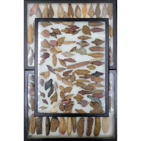
Lot Of Large Display Boxes Of Spear Heads, Arrow Heads, And Stone Tools From Madden LakeRbfinearts4.4(571)See Sold PriceFeb 24, 2024
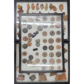
Lot Of Large Display Boxes Of Pottery Fragments, Stone Points, And Spindle Whorls From Madden LakeRbfinearts4.4(571)See Sold PriceFeb 24, 2024
Alton Tobey, Ships going through Panama CanalLotus International Auctions, LLC4.6(153)See Sold PriceMar 03, 2024
Alton S. Tobey, Building the Panama CanalLotus International Auctions, LLC4.6(153)See Sold PriceMar 03, 2024
Group of 15 Printed or Lithographed Items, including: litho...Potter & Potter Auctions4.6(539)See Sold PriceMar 07, 2024
Group of 3 Vintage Engineering Company BooksMatthew Bullock Auctioneers4.7(1.8k)See Sold PriceFeb 24, 2024
Strickler, Rare - San Francisco, CaliforniaTrillium Antique Prints & Rare Books4.5(30)See Sold PriceFeb 24, 2024
A23 United States in the Caribbean Denoyer-Geppert Social Science MapsJasper524.5(9.8k)See Sold PriceFeb 27, 2024