Map 'America sive India Nova', 17th centuryWatercoloured map, 'America sive India Nova ad magnae Gerardi Mercatoris avi universalis imitationem incompendium redacta', by Michael Mercator, Amsterdam, c.1600. Framed. Dim.:33,5x42cm.See Sold Price
SoldAfter Michael Mercator(Dutch, late 16th/early 17th century) Map of the Americas, entitled: [America sive India Nova ad magnae Gerardi Mercatoris aui Uiniversalis imitationem in compendium redacta], 1595-1619, modern facsimSee Sold Price
SoldPenn Prints Map of America, Mercator20th century reprint, after Michael Mercator (ca. 1567-1600), America sive India Nova ad magnae Gerardi Mercatoris avi universalis imitationem incompendium redacta, print no. G365, Penn Prints, NewSee Sold Price
SoldOrtelius Map of AmericaEarly 17th century map tiled "Americae Sive Novi Orbis, Nova Descriptio" by Abraham Ortelius showing North and South America. First published in 1570, this 1606 edition was published in London. MapSee Sold Price
SoldMAP: AMERICA SIVE INDIA NOVA, ETCHING, C.1615Title: Map: America Sive India Nova, Printmaker: Michael Mercator, Pub: Jodocus Hondius, Date: (1595) Circa 1615, Medium: HC Etching, Paper size: 17 x 21, Inscribed: Publisher identified in matrix, CoSee Sold Price
SoldSplendid Map by Mercator, America Sive India Nova, 1595America sive India Nova. ad magnae Gerardi Mercatoris aui Vniversalis imitationem in compendi um redacta Cartographer: Gerhard Mercator (1512-1594) after Michael Mercator (1491-1544), Duisburg, 1595 PSee Sold Price
Mercator Map of America*** START PRICE IS THE RESERVE *** [America] MERCATOR, Gerald (1512-1594) & MERCATOR, Michael (1567-1600). America Sive India Nova. Engraved map with original hand color in full. Amsterdam: Hondius, cSee Sold Price
SoldMercator Map of AmericaMercator, Gerard (1512-1594) & Mercator, Michael (1567-1600). America sive India Nova... Engraved map with original hand color in full. Amsterdam: Hondius, c. 1607. 17 1/2" x 21" sheet, 26 1/2" x 30 "See Sold Price
Mercator Map of AmericaMERCATOR, Gerard (1512-1594) - MERCATOR, Michael (1567-1600). America sive India Nova. Engraved map with original hand color in full. Amsterdam: Hondius, c. 1607. 17 1/2 x 21 inches sheet, 26 1/2 x 30See Sold Price
Sold(Maps and Charts, Western Hemisphere), Mercator, M(Maps and Charts, Western Hemisphere), Mercator, Michael, America sive India Nova ad magnae Gerardi Mercatoris, [Duisburg, c. 1585 or later], taken from Atlantis pars altera, hand-colored, sheet sizeSee Sold Price
Sold1613 America sive India Nova ad magnae GerardiBy: Michael MercatorDate: 1613 / DuisbergDimensions: 16 x 19.5 inches (40.7 x 49.5 cm)This is an authentic antique map of the Western Hemisphere by Michael Mercator. The map is based on Rumold MercatoSee Sold Price
SoldMichael Mercator America sive India Nova engraMichael Mercator America sive India Nova engraved western hemisphere map, 14 3/4'' x 18 1/2''.See Sold Price
SoldAmerica Sive India Nova by MichaelMercator Duisberg, circa 1613, one of the most famous hemispherical maps of the Americas and an excellent foundation for an American map collection, Burden #89, nicely hand-colored, text on the verso,See Sold Price
SoldAmerica sive India NovaMichael Meractor (1565/70-1614). Amsterdam: Hondius, 1609-1639. Engraved Map with original hand color. 17 x 21 1/2 inches sheet, 28 1/2 x 33 inches framed. A fine example of one of the most celebratedSee Sold Price
SoldRare Michael Mercator Map of the AmericasAmerica sive India Nova...Michael Mercator (c. 1567-1600). Engraved map with original hand color. Duisburg, 1595 (but Hondius: Amsterdam, 1613 or later). 15 x 18 1/2 inches visible, 26 x 29 inches fraSee Sold Price
Mercator, M. America sive India Nova ad magnae GerardiMercator, Michael America sive India Nova ad magnae Gerardi Mercatoris 1619 Copperplate engraving, coloured Printed Area: 57.6 x 48.3; 22.7 x 19 in Mercator's map of America is derived from his worldSee Sold Price
SoldAmerica sive India NovaAmerica sive India Nova, Gerard Mercator, 1595-1612. A very decorative map of the Western Hemisphere by Mercator showing ornate floral strap work border with three round inset maps and title. BeautifuSee Sold Price
SoldEngraved Map of the Americas by Gerard & MichaelAmerica sive India Nova. Gerard (1512-1594) & Michael Mercator (c. 1567-1600). Engraved Map with Hand Color in Full. Amsterdam: Hondius, c. 1607. 17 1/2 x 21 inches sheet, 26 1/2 x 30 1/2 inches frameSee Sold Price
SoldAmerica Sive India Nova.Michael Mercator (1491 - 1544). Duisberg: Rumold Mercator, 1595. 18 4/8 x 22 inches. Timeless, Classic, & Iconic Image of The New World by the Greatest Genius of Cartography Ever. Decorative example oSee Sold Price
SoldMercator, Michael160. Mercator, Michael.America sive India Nova. Double-page engraved hemispheric map, outlined in color. 18-3/4 x 22-1/2 inches, including margins, Latin text on verso, matted, in glass-fronted frame;See Sold Price
SoldGeorg Matthaus Seutter (German, 1678-1757) 17C MapGeorg Matthaus Seutter (German, 1678-1757) 17th century map. Nova Belgii America Septentrionali hand colored engraved map. In good condition, not glued down, tape hinge at top, there is a quarter inchSee Sold Price
SoldNieuwenhof map of New YorkNIEUWENHOF, Evert (17th century). NOVA BELGICA SIVE NIEUW NEDERLANDT. Engraved map. Amsterdam: 1656. 12 1/8" x 7 5/8" sheet, 14 3/4" x 15 1/4" framed. PROVENANCE: Richard B. Arkway, New York, 2005; VoSee Sold Price
SoldWillem Blaeu Map of Southeastern North America,Willem Blaeu Map of Southeastern North America, "Virginiae partis australis, et Floridae partis orientalis, interjacentiumq regionum Nova Descriptio'" Amsterdam, 17th century, copperplate engraving shSee Sold Price
SoldAmericae Sive Novi Orbis, Nova DescriptioAbraham Ortelius (1527-1598). engraved map with original hand-color in full. Antwerp, 1579-84. 15 x 20 inches. The map is one of the most influential maps of the 16th and early 17th Centuries, havingSee Sold Price
17th Century Hand Colored Engraved Map of GermanyGlobal Auctions Company4.3(36)See Sold PriceMar 03, 2024
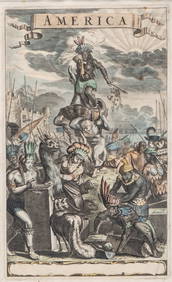
Antique Hand Colored Print "America" by Jacob van MeursCollective Hudson4.5(56)See Sold PriceMar 01, 2024
Willem Blaeu, Etc. 17th C. Antiquarian Maps, 2Auctions at Showplace4.6(731)See Sold PriceMar 17, 2024
Great Apostle Saint Paul subduing the Evil Portuguese colonial of Goa, Portuguese colonial work fromTemplum Fine Art Auctions4.3(8)See Sold PriceFeb 28, 2024
1629 SPAIN Hispania sive de regis antique Johannes Laet ELZEVIER 17th centuryJasper524.5(9.8k)See Sold PriceFeb 27, 2024
New and Correct Map of North America With the West India Islands,Jasper524.5(9.8k)See Sold PriceFeb 27, 2024
WEST AFRICA Niger/Gambia rivers tribes towns. 'Pays des Negres'. MALLET 1683 mapJasper524.5(9.8k)See Sold PriceFeb 28, 2024
WEST AFRICA. Guinea. Nigeria Ghana Benin Togo Sierra Leone. MALLET 1683 mapJasper524.5(9.8k)See Sold PriceFeb 28, 2024
WEST CENTRAL AFRICA. Congo Angola Gabon Cameroon Sao Tome. MALLET 1683 old mapJasper524.5(9.8k)See Sold PriceFeb 28, 2024
NORTH AFRICA. 'Biledulgerid', a former North African country. MALLET 1683 mapJasper524.5(9.8k)See Sold PriceFeb 28, 2024
WEST AFRICA/MAGHREB Tribes Garamantes Getgulie 'Ancienne Libye'. MALLET 1683 mapJasper524.5(9.8k)See Sold PriceFeb 28, 2024
NORTH AFRICA. Barbary. Morocco Tunisia Libya Egypt. 'Barbarie'. MALLET 1683 mapJasper524.5(9.8k)See Sold PriceFeb 28, 2024
NORTH AFRICA. Morocco Tunisia Libya. 'Mauritanie'. Malta Melita. MALLET 1683 mapJasper524.5(9.8k)See Sold PriceFeb 28, 2024
NUBIA. 'Nubie'. Nile Valley. Sudan Ethiopia Egypt. MALLET 1683 old antique mapJasper524.5(9.8k)See Sold PriceFeb 28, 2024
SUB-SAHARAN AFRICA. 'Ancienne Ethiopie'. Ancient Ethiopia. MALLET 1683 old mapJasper524.5(9.8k)See Sold PriceFeb 28, 2024
Blackie (Pub) 1882 Folio Map. West India Islands & Central AmericaAlbion Auctions4.6(341)See Sold PriceMar 01, 2024