Battista Agnese - Portolan Or Navigational Map OfBattista Agnese - Portolan Or Navigational Map Of Greece, The Mediterranean And The Levant Size: 36 X 24 1/8 In. - This Is A Gallery Stretched Giclee Print On Canvas. The Piece Was Printed On High QuaSee Sold Price
BATTISTA AGNESE - PORTOLAN OR NAVIGATIONAL MAP OF THEBattista Agnese - Portolan Or Navigational Map Of The Western Mediterranean From Gibraltar To Piedmont & Sardinia - 36 X 24 1/8 In. - This Giclée Print Is Gallery Stretched And Ready To Hang Or LeanSee Sold Price
BATTISTA AGNESE - PORTOLAN OR NAVIGATIONAL MAP OF THEBattista Agnese - Portolan Or Navigational Map Of The Western Mediterranean From Gibraltar To Piedmont & Sardinia - 44 X 29 1/2 In. This is a Giclée on Canvas. Very Large Piece!See Sold Price
BATTISTA AGNESE - PORTOLAN OR NAVIGATIONAL MAP OF THEBATTISTA AGNESE - PORTOLAN OR NAVIGATIONAL MAP OF THE SPAIN, GIBRALTAR & NORTH AFRICA - Giclée on Canvas 36 x 24 1/8 in. - A Giclée Print Is The Highest Quality Print Available Today. Because ThereSee Sold Price
BATTISTA AGNESE - PORTOLAN OR NAVIGATIONAL MAP OF THEBattista Agnese - Portolan Or Navigational Map Of The Spain, Gibraltar & North Africa - 44 X 29 1/2 In. This is a Giclée on Canvas. Very Large Piece!See Sold Price
BATTISTA AGNESE - PORTOLAN OR NAVIGATIONAL MAP OF THEBattista Agnese - Portolan Or Navigational Map Of The Western Mediterranean From Gibraltar To Piedmont & Sardinia - 44 X 29 1/2 In. - This Giclée Print Is Gallery Stretched And Ready To Hang Or LeanSee Sold Price
BATTISTA AGNESE - PORTOLAN OR NAVIGATIONAL MAP OFBattista Agnese - Portolan Or Navigational Map Of Greece, The Mediterranean And The Levant - Giclée On Canvas 36 X 24 1/8 In. - A Giclée Print Is The Highest Quality Print Available Today. Because TSee Sold Price
Battista Agnese - Portolan Or Navigational Map Of TheBattista Agnese - Portolan Or Navigational Map Of The Spain, Gibraltar & North Africa - 40 X 26 3/4 In. - Giclée On Canvas - Museum Wrapped - Large Piece Of Art - This Piece Is Ready To Hang On YourSee Sold Price
BATTISTA AGNESE - PORTOLAN OR NAVIGATIONAL MAP OF THEBattista Agnese - Portolan Or Navigational Map Of The Western Mediterranean From Gibraltar To Piedmont & Sardinia - 44 X 29 1/2 In. - Giclée Print - Gallery Stretched - Ready to hang.See Sold Price
BATTISTA AGNESE - PORTOLAN OR NAVIGATIONAL MAP OF THEBattista Agnese - Portolan Or Navigational Map Of The Spain, Gibraltar & North Africa - Giclée On Canvas - 30 X 20 1/8 In. - A Giclée Print Is The Highest Quality Print Available Today. Because TherSee Sold Price
Battista Agnese - Portolan Or Navigational Map Of TheBattista Agnese - Portolan Or Navigational Map Of The Western Mediterranean From Gibraltar To Piedmont & Sardinia Size: 36 X 24 1/8 In. - This Is A Gallery Stretched Giclee Print On Canvas. The PieceSee Sold Price
BATTISTA AGNESE - PORTOLAN OR NAVIGATIONAL MAP OF THEBattista Agnese - Portolan Or Navigational Map Of The Spain, Gibraltar & North Africa - 40 X 26 3/4 In. - Giclée On Canvas - Museum Wrapped - Large Piece Of Art - This Piece Is Ready To Hang On YourSee Sold Price
BATTISTA AGNESE - PORTOLAN OR NAVIGATIONAL MAP OF THEBattista Agnese - Portolan Or Navigational Map Of The Black Sea Showing Anthropomorphic Winds - 40 X 26 3/4 In. - This Giclée Print Is Gallery Stretched And Ready To Hang Or Lean Against A Wall, Or DSee Sold Price
BATTISTA AGNESE - PORTOLAN OR NAVIGATIONAL MAP OF THEBattista Agnese - Portolan Or Navigational Map Of The Black Sea Showing Anthropomorphic Winds - 36 X 24 1/8 In. - This Giclée Print Is Gallery Stretched And Ready To Hang Or Lean Against A Wall, Or DSee Sold Price
BATTISTA AGNESE - PORTOLAN OR NAVIGATIONAL MAP OF THEBattista Agnese - Portolan Or Navigational Map Of The Black Sea Showing Anthropomorphic Winds - 16 X 10 3/4 In. - This Giclée Print Is Gallery Stretched And Ready To Hang Or Lean Against A Wall, Or DSee Sold Price
BATTISTA AGNESE - PORTOLAN OR NAVIGATIONAL MAP OF THEBattista Agnese - Portolan Or Navigational Map Of The Western Mediterranean From Gibraltar To Piedmont & Sardinia - 40 X 26 3/4 In. - Gallery Stretched The Piece Of Art Is Ready To Hang Or Lean AgainsSee Sold Price
BATTISTA AGNESE -PORTOLAN OR NAVIGATIONAL MAP OF THEBattista Agnese -portolan Or Navigational Map Of The Black Sea Showing Anthropomorphic Winds - Giclée On Canvas -44 X 29 1/2 In. - A Giclée Print Is The Highest Quality Print Available Today. BecausSee Sold Price
BATTISTA AGNESE -PORTOLAN OR NAVIGATIONAL MAP OF THEBattista Agnese -portolan Or Navigational Map Of The Western Mediterranean From Gibraltar To Piedmont & Sardinia - Giclée On Canvas -44 X 29 1/2 In. - A Giclée Print Is The Highest Quality Print AvaSee Sold Price
Battista Agnese - Portolan Or Navigational Map Of TheBattista Agnese - Portolan Or Navigational Map Of The Black Sea Showing Anthropomorphic Winds Size: 44 X 29 1/2 In. - This Is A Gallery Stretched Giclee Print On Canvas. The Piece Was Printed On HighSee Sold Price
Battista Agnese - Portolan Or Navigational Map Of TheBattista Agnese - Portolan Or Navigational Map Of The Black Sea Showing Anthropomorphic Winds - 40 X 26 3/4 In. - Giclée On Canvas - Museum Wrapped - Large Piece Of Art - This Piece Is Ready To HangSee Sold Price
BATTISTA AGNESE - PORTOLAN OR NAVIGATIONAL MAP OF THEBattista Agnese - Portolan Or Navigational Map Of The Spain, Gibraltar & North Africa - 40 X 26 3/4 In. - Giclée On Canvas - Museum Wrapped - Large Piece Of Art - This Piece Is Ready To Hang On YourSee Sold Price
BATTISTA AGNESE - PORTOLAN OR NAVIGATIONAL MAP OF THEBattista Agnese - Portolan Or Navigational Map Of The Western Mediterranean From Gibraltar To Piedmont & Sardinia - 36 X 24 1/8 In. - Giclée Print - Gallery Stretched - Ready to hang.See Sold Price
BATTISTA AGNESE - PORTOLAN OR NAVIGATIONAL MAP OF THEBattista Agnese - Portolan Or Navigational Map Of The Black Sea Showing Anthropomorphic Winds - 40 X 26 3/4 In. - Giclée On Canvas - Museum Wrapped - Large Piece Of Art - This Piece Is Ready To HangSee Sold Price
BATTISTA AGNESE - PORTOLAN OR NAVIGATIONAL MAP OF THEBattista Agnese - Portolan Or Navigational Map Of The Spain, Gibraltar & North Africa - 40 X 26 3/4 In. - Gallery Stretched The Piece Of Art Is Ready To Hang Or Lean Against A Wall, Or Display On An ESee Sold Price
Central Railroad of New Jersey Map of Sandy Hook Route-ca. 1903JM Hobby Supply and Railroad Artifact Auctions4.4(126)See Sold PriceFeb 24, 2024
Rand McNally/Santa Fe Railroad Map of Iowa-1912JM Hobby Supply and Railroad Artifact Auctions4.4(126)See Sold PriceFeb 24, 2024
LATE 17TH C. FRENCH MAP OF THE NEW WORLD BY ALEXIS-HUBERT JAILLOT (1632-1712)Thomaston Place Auction Galleries4.4(386)See Sold PriceFeb 24, 2024
18TH C. ANTIQUE MAP: FRENCH & INDIAN WAR, FRAMEDThomaston Place Auction Galleries4.4(386)See Sold PriceFeb 24, 2024
Keith Haring - Ink on New York Map, Best Buddies, Inscribed, Signed, and DatedSapphire Auction Gallery4(67)See Sold PriceMar 02, 2024
Rand McNally Railroad Map Cabinet w/ 21 Railroad MapsRail & Road Auctions4.6(165)See Sold PriceMar 08, 2024
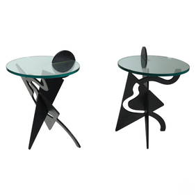
Pucci De Rossi Pair of Steel Battista Side TablesHill Auction Gallery 4.7(1k)See Sold PriceFeb 28, 2024
Putnam - First Map of the State of Ohio by Rufus PutnamTrillium Antique Prints & Rare Books4.5(30)See Sold PriceFeb 24, 2024
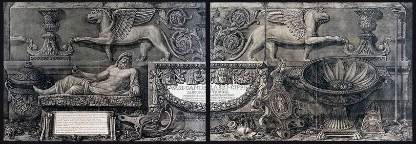
Passeri - 6 Etruscan Vase EngravingsTrillium Antique Prints & Rare Books4.5(30)See Sold PriceFeb 24, 2024
1750 Bowen Map of Bermuda and St. Kitts -- A New & Accurate Map of Bermudas or Sommer's Islands...Jasper524.5(9.8k)See Sold PriceFeb 27, 2024
1764 Bellin Map of Port Antonio, Jamaica -- Plan des Havres de Port Antonio et de Saint FrancoisJasper524.5(9.8k)See Sold PriceFeb 27, 2024
Southern Africa Cape of Good Hope-Madagascar ADMIRALTY sea chart 1935 (1955) mapJasper524.5(9.8k)See Sold PriceFeb 28, 2024
Gulf of Guinea. Ghana Togo Benin Nigeria. ADMIRALTY sea chart 1928 (1954) mapJasper524.5(9.8k)See Sold PriceFeb 28, 2024
South Namibia coast. Walvis Bay-Orange River ADMIRALTY sea chart 1881 (1954) mapJasper524.5(9.8k)See Sold PriceFeb 28, 2024