SoldValentia.Voyages and Travels to India,AtlasValentia (George Annesley, Viscount) Voyages and Travels to India...,Atlas only, second edition, 58 engraved maps and plates only (of 72), 9 folding, lightly foxed, water-stained, modern clothSee Sold Price
SoldValentia.Voyages &Travels to India..,4v,1811Valentia (George Annesley, Viscount) Voyages and Travels to India, Ceylon, the Red Sea, Abyssinia, and Egypt...4 vol. including Atlas, second edition, 72 engraved maps and plates, some foldingSee Sold Price
SoldValentia. Voyages and Travels to India...Valentia (George Annesley, Viscount) Voyages and Travels to India, Ceylon, the Red Sea, Abyssinia, and Egypt,3 vol., first edition, large paper copy, 69 engraved plates and maps, some folding,See Sold Price
SoldAnnesley Travels to India, CeylonAnnesley (George Viscount Valentia) Voyages and Travels to India, Ceylon, the Red Sea, Abyssinia and Egypt in the Years 1802, 1803..., 4 vol., including plate vol., 72 engraved plates and mapsSee Sold Price
SoldAnnesley (George, Viscount Valentia) Voyages andAnnesley Annesley (George, Viscount Valentia) Voyages and Travels to India, Ceylon, the Red Sea, Abyssinia, and Egypt..., 3 vol., first edition, half-titles, 3 engraved head-pieces and 69 plSee Sold Price
SoldGeorge, Viscount Valentia. Voyages and Travels tGeorge, Viscount Valentia. Voyages and Travels to India, Ceylon, The Red Sea, AbyssSee Sold Price
SoldThomas Jefferys (English, 1719-1771)Thomas Jefferys (English, 1719-1771) , "The Isthmus of Panama with the Coast from Great River on the Moskito Shore to Cartagena", London, Laurie & Whittle, 1794, from West India Atlas, 19 in. x 24 1/2See Sold Price
SoldThe Coast of West Florida and Louisiana, 1794by Thomas Jefferys (1719-1771), 1794, a hand-colored map and sea chart of the southern coast from Louisiana to western Florida from Jefferys' West India Atlas, detailing the trade routes uSee Sold Price
SoldThe West-India Atlas...The West-India Atlas: or, A Compendious Description of the West-Indies... JEFFERYS, Thomas (1719-1771). London: Robert Sayer and John Bennett, 1775. Folio (22 x 16 4/8 inches).Physical Description: FoSee Sold Price
SoldThe Western Coast of Louisiana and The Coast of New...The Western Coast of Louisiana and The Coast of New Leon from the West India Atlas. Thomas Jeffreys (c. 1719 – 1771). London: Laurie and Whittle, 1794. 21 x 27 4/8 inches. The most active and celebrSee Sold Price
SoldThomas Jefferys (English, 1719-1771) MapThomas Jefferys (English, 1719-1771), "The Isthmus of Panama with the Coast from Great River on the Moskito Shore to Cartagena", London, Laurie & Whittle, 1794, from West India Atlas, 19 in. x 24 1/2See Sold Price
Print Court of Gran Mogol Mughal India 1752 CopperBeautiful print of 1752 of the Court of Gran Mogol in India. Atlas: Histoire generale des voyages Author: Jaques Nicolas Bellin (1702-1720) Date: 1752 Technique: Copper etching Leaf Dimension: 25,5x37See Sold Price
Bellin: Antique View of Court of Gran Mughal India 1752Map: Beautiful print of 1752 of the Court of Gran Mogol in India. Atlas: Histoire generale des voyages Author: Jaques Nicolas Bellin (1702-1720) Date: 1752 Technique: Copper etching Leaf Dimension: 25See Sold Price
View Dabhol India 1750 circa Copper etching BellinBeautiful view of 1750 circa of the city of Dabhol, India. Atlas: Antonine de Prevost d Exile s, Histoire generale des voyages Author: Jaques Nicolas Bellin (1702-1720) Date: 1750 circa Technique: CopSee Sold Price
The Bermudas or Summer's Islands MapCopy of sheet from the West India Atlas, of the 18th Century. Map reprinted and hand colored in 1968 by The Meriden Gravure Barre Publishers. The Bermudas, or Summer's Islands. From a Survey by C. LemSee Sold Price
Early Caribbean Island Map PrintFrom the West India Atlas of the 18th Century, Map reprinted and hand colored in 1968 by the Meriden Gravure Company for Barre Publishers. Copy of 1775 map The Caribbee Islands The Virgin Island and tSee Sold Price
Bellin: Antique View Surat India 1765Map: Beautiful print of 1765 of the city of Surat in India. Atlas: Histoire generale des voyages Author: Jaques Nicolas Bellin (1702-1720) Date: 1765 Technique: Copper etching Leaf Dimension: 23,5x30,See Sold Price
MAP, Havana & Matanzas, Cuba, SayerHavana & Matanzas, Cuba. Robert Sayer, Plan of the City and Harbour of Havanna [on sheet with] Plan of the Bay of Matanzas, on the North Side of Cuba, from West-India Atlas, 1788 (dated). Hand Color.See Sold Price
The Bermudas or Summer's Islands MapCopy of sheet from the West India Atlas, of the 18th Century. Map reprinted and hand colored in 1968 by The Meriden Gravure Barre Publishers. The Bermudas, or Summer's Islands. From a Survey by C. LemSee Sold Price
SoldJefferys Map of the Texas CoastlineJEFFERYS, Thomas (1719-1771). The Western Coast of Louisiana and the coast of New Leon. Engraved map from The West India Atlas. London, 1794. 21" x 27 1/2" sheet, 33" x 39" framed. First published inSee Sold Price
Early Caribbean Island Map PrintFrom the West India Atlas of the 18th Century, Map reprinted and hand colored in 1968 by the Meriden Gravure Company for Barre Publishers. Copy of 1775 map The Caribbee Islands The Virgin Island and tSee Sold Price
Jeffreys Map of Gulf CoastJEFFERYS, Thomas (1719-1771). The Western Coast of Louisiana and the coast of New Leon. Copperplate engraving from The West India Atlas. London, 1794. 21 x 27 1/2 inches sheet, 33 x 39 inches framed FSee Sold Price
Laurie & Whilttle: Venezuela Ports, War of Jenkin’s EarPlan of the Road and Town of La Guayra on the Coast of Caraccas / Plan of Puerto Cavello on the Coast of the Caracas A scarce sheet from Laurie & Whittle's West India Atlas with plans of two major VenSee Sold Price
Bellin: Antique View Dabhol India 1750Map: Beautiful view of 1750 circa of the city of Dabhol, India. Atlas: Antonine de Prevost d Exile s, Histoire generale des voyages Author: Jaques Nicolas Bellin (1702-1720) Date: 1750 circa TechniqueSee Sold Price
1825 Sketches of INDIA & Peninsula WAR Sherer Napoleonic Portugal 2in1 NapoleonSchilb Antiquarian Rare Books4.8(421)See Sold PriceMar 31, 2024
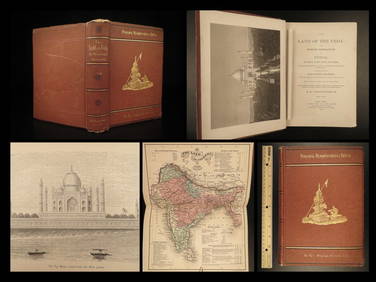
1872 INDIA Land of the Veda Travel Exploration Voyages Hindu Sepoy RebellionSchilb Antiquarian Rare Books4.8(421)See Sold PriceMar 31, 2024
Duval - Pair: Map of India & Map of MaldivesTrillium Antique Prints & Rare Books4.5(30)See Sold PriceFeb 24, 2024
Churchill & Nieuhof 1744 Folio Print. India - Malabar Man & WomanAlbion Auctions4.6(336)See Sold PriceMar 07, 2024
Churchill & Nieuhof 1744 Folio Print. India - Snake Charmer, MalabarAlbion Auctions4.6(336)See Sold PriceMar 07, 2024
Churchill & Nieuhof 1744 LG Folio Print. India - Pearl Fishery, Toutte CourynAlbion Auctions4.6(336)See Sold PriceMar 07, 2024
Churchill & Nieuhof 1744 LG Folio Print. India - Taking of Cochin, ShipsAlbion Auctions4.6(336)See Sold PriceMar 07, 2024
Churchill & Nieuhof 1744 Print. India - Nieuhof & Queen of Koylang, Bats & Malabar MammalsAlbion Auctions4.6(336)See Sold PriceMar 07, 2024
Blackie (Pub) 1882 Folio Map. West India Islands & Central AmericaAlbion Auctions4.6(336)See Sold PriceMar 01, 2024
ANTIQUE ILLUSTRATED HANDBOOK OF GEOGRAPHY AND TRAVEL IN ASIA, VOLUME 2, 1896NY Elizabeth 4.3(84)See Sold PriceMar 03, 2024
Sergio Villaquiran Tahj Mahal India Crown Of Palaces Travel WorldSeized Assets Auctioneers4.3(601)See Sold PriceFeb 24, 2024
Ganga Varanasi Benares Riverbank India Sergio Villarquiran Nature TravelSeized Assets Auctioneers4.3(601)See Sold PriceFeb 26, 2024
Early 1960s Ethnic Travel Photograph AlbumWilliam Bunch Auctions & Appraisals4.6(876)See Sold PriceFeb 27, 2024
Taj Mahal Certified Photograph Richard Silver India Travel World PlacesSeized Assets Auctioneers4.3(601)See Sold PriceFeb 29, 2024