SoldAn Early Eman. Bowen Engraved Map,An Early Eman. Bowen Engraved Map, plate stamped, "A New and Accurate Map of Turkey in Asia, Arabia, etc......". Matted and framed under glass, 14 1/2" high, 17 1/2" wide. Some foxing.See Sold Price
Sold1 piece. Hand-Colored Engraved Map. Bowen, Eman.1 piece. Hand-Colored Engraved Map. Bowen, Eman. An Accurate Map of The County of Kent Divided into its Lathes." London: J. Tinney, 1753. 20 1/2 x 27 1/2 inches; 520 x 698 mm, full margins. Slightly aSee Sold Price
SoldHistory (The) of China.History (The) of China.Upon the Plan of Mr Rollin's Antient History, vol. I (all published), folding hand-coloured engraved map by Eman: Bowen, map with small tear, Z8 torn and repaired withSee Sold Price
SoldAntique Engraved Map of Chester, EnglandAn antique hand colored map of the County of Chester, England. By Eman. Bowen. Framed under glass. Mat opening: 21 in x 27-1/2 in. Some light toning and spotting.See Sold Price
SoldENGRAVED MAP OF THE KNOWN WORLD, EMAN BOWEN 1744ENGRAVED MAP OF THE KNOWN WORLD, EMAN BOWEN 1744. SHEET 14 3/4 X 23 1/4"See Sold Price
SoldMap, Eman. Bowen, A New General Map of AmericaFramed hand-colored engraved map, ''A New General Map of America,'' circa 1747, by Eman. Bowen, overall: 16.25''h x 20.5''wSee Sold Price
SoldWorld.- Gibson (John) Atlas Minimus, or a New Set ofWorld.- Gibson (John) Atlas Minimus, or a New Set of Pocket Maps ... of the known World... Revis'd, Corrected and Improv'd by Eman: Bowen, engraved throughout with frontispiece, calligraphic title, prSee Sold Price
SoldAtlases.- Gibson (J.) Atlas Minimus, 1758.Gibson (John) Atlas Minimus, or a New Set of Pocket Maps ... of the known World ... revis'd, corrected and improv'd by Eman: Bowen, first edition, engraved title, frontispiece, preface leaf, index leaSee Sold Price
OGILBY, John. Britannia Depicta oOGILBY, John. Britannia Depicta o 139 ff, each leaf fully engraved by Eman. Bowen with script text, maps and decorative borders, last 137 ff numbered 1-273. 4to., 192 x 130 mm, bound in contemporary fSee Sold Price
A map of the world. 19th.Lithography titled „A map of the world with the Ship „Duke & „Dutchess Tract round it from 1708 to 1711.Author/compiler - Herman Moll.Engraved by Eman Bowen.From Illus. in: Woodes Rogers, A CruiSee Sold Price
SoldMAP-1750 New and Accurate Map of America By BowenHistoric Maps1750 "A New and Accurate Map of America..." By Bowen 1750 Engraved Hand-Colored Map entitled, "A New and Accurate Map of America..." engraved by Emanuel Bowen, Choice VerySee Sold Price
SoldEARLY HAND COLORED MAP OF CUBA, HISPANOLA & PORTO RICO,"A New and Acurate Map of the Island of Cuba, Drawn from the most approved Maps & Charts, and Regulated by Astron. Observat. By Eman Bowen" & "A New and Accurate Map of Hispaniola or St. Domingo and PSee Sold Price
Early 18thc Engraved Maps, Road to LondonOriginal early 18th century engravings, Emanuel Bowen ( 1714 - 1767 ) "Map of the Road from London to Dover in Kent". 7 1/4" X 9 3/4" along with "Map of the Road from London to Hith." 7 1/4" X 4 3/4".See Sold Price
Early 18thc Engraved Maps, Road to LondonOriginal early 18th century engravings, Emanuel Bowen ( 1714 - 1767 ) "Map of the Road from London to Dover in Kent". 7 1/4" X 9 3/4" along with "Map of the Road from London to Hith." 7 1/4" X 4 3/4".See Sold Price
Early 18thc Engraved Maps, Road to LondonOriginal early 18th century engravings, Emanuel Bowen ( 1714 - 1767 ) "Map of the Road from London to Dover in Kent". 7 1/4" X 9 3/4" along with "Map of the Road from London to Hith." 7 1/4" X 4 3/4".See Sold Price
SoldEarly 18thc Engraved Maps, Road to LondonOriginal early 18th century engravings, Emanuel Bowen ( 1714 - 1767 ) "Map of the Road from London to Dover in Kent". 7 1/4" X 9 3/4" along with "Map of the Road from London to Hith." 7 1/4" X 4 3/4".See Sold Price
Early 18thc Engraved Maps, Road to LondonOriginal early 18th century engravings, Emanuel Bowen ( 1714 - 1767 ) "Map of the Road from London to Dover in Kent". 7 1/4" X 9 3/4" along with "Map of the Road from London to Hith." 7 1/4" X 4 3/4".See Sold Price
Early 18thc Engraved Maps, Road to LondonOriginal early 18th century engravings, Emanuel Bowen ( 1714 - 1767 ) "Map of the Road from London to Dover in Kent". 7 1/4" X 9 3/4" along with "Map of the Road from London to Hith." 7 1/4" X 4 3/4".See Sold Price
Early 18thc Engraved Maps, Road to LondonOriginal early 18th century engravings, Emanuel Bowen ( 1714 - 1767 ) "Map of the Road from London to Dover in Kent". 7 1/4" X 9 3/4" along with "Map of the Road from London to Hith." 7 1/4" X 4 3/4".See Sold Price
Early 18thc Engraved Maps, Road to LondonOriginal early 18th century engravings, Emanuel Bowen ( 1714 - 1767 ) "Map of the Road from London to Dover in Kent". 7 1/4" X 9 3/4" along with "Map of the Road from London to Hith." 7 1/4" X 4 3/4".See Sold Price
Early 18thc Engraved Maps, Road to LondonOriginal early 18th century engravings, Emanuel Bowen ( 1714 - 1767 ) "Map of the Road from London to Dover in Kent". 7 1/4" X 9 3/4" along with "Map of the Road from London to Hith." 7 1/4" X 4 3/4".See Sold Price
Early 18thc Engraved Maps, Road to LondonOriginal early 18th century engravings, Emanuel Bowen ( 1714 - 1767 ) "Map of the Road from London to Dover in Kent". 7 1/4" X 9 3/4" along with "Map of the Road from London to Hith." 7 1/4" X 4 3/4".See Sold Price
Early 18thc Engraved Maps, Road to LondonOriginal early 18th century engravings, Emanuel Bowen ( 1714 - 1767 ) "Map of the Road from London to Dover in Kent". 7 1/4" X 9 3/4" along with "Map of the Road from London to Hith." 7 1/4" X 4 3/4".See Sold Price
Early 18thc Engraved Maps, Road to LondonOriginal early 18th century engravings, Emanuel Bowen ( 1714 - 1767 ) "Map of the Road from London to Dover in Kent". 7 1/4" X 9 3/4" along with "Map of the Road from London to Hith." 7 1/4" X 4 3/4".See Sold Price
Arrowsmith & Lewis - Map of PolynesiaTrillium Antique Prints & Rare Books4.5(30)See Sold PriceFeb 24, 2024
Arrowsmith & Lewis - Map of North AmericaTrillium Antique Prints & Rare Books4.5(30)See Sold PriceFeb 24, 2024
Arrowsmith & Lewis - Map of the World on Mercator's ProjectionTrillium Antique Prints & Rare Books4.5(30)See Sold PriceFeb 24, 2024
Arrowsmith & Lewis - Map of LouisianaTrillium Antique Prints & Rare Books4.5(30)See Sold PriceFeb 24, 2024
Arrowsmith & Lewis - Map of the United StatesTrillium Antique Prints & Rare Books4.5(30)See Sold PriceFeb 24, 2024
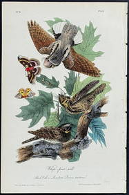
Audubon - Common Osprey Fish Hawk. 15Trillium Antique Prints & Rare Books4.5(30)See Sold PriceFeb 24, 2024
Map: An 18thC engraved map of Bedfordshire titled An Accurate Map of the County of Bedford DividedClaydon Auctioneers Ltd4.3(125)See Sold PriceFeb 26, 2024
Emory's Notes of a Military Reconnoissance larger issuePBA Galleries4.7(381)See Sold PriceMar 07, 2024
Western Africa by Edward Weller. Early British/French settlements 1860 old mapJasper524.5(9.8k)See Sold PriceFeb 28, 2024
WEST AFRICA II. NIGERIA. Bight of Benin-Lake Chad. Yariba Houssa. SDUK 1851 mapJasper524.5(9.8k)See Sold PriceFeb 28, 2024
NIGERIA early explorers' routes. Lake Chad. Yariba Houssa Borgou SDUK 1844 mapJasper524.5(9.8k)See Sold PriceFeb 28, 2024
NIGERIA w/ early explorers' routes. Lake Chad Yariba Houssa Borgou.SDUK 1844 mapJasper524.5(9.8k)See Sold PriceFeb 28, 2024
Western Africa by Edward Weller. Early British/French settlements 1859 old mapJasper524.5(9.8k)See Sold PriceFeb 28, 2024