Sold1870 County Map of Texas - Mitchell, Samuel AMitchell, Samuel Augustus. County map of Texas, hand-col. Philadelphia: W.H. Gamble, 1870One hundred mile scaleDimensions: 9 1/4" X 11 7/8"Note: Insert of Galveston Bay and vicinityInv.30See Sold Price
1870 County Map of Texas Mitchell, Samuel AugustusMitchell, Samuel Augustus. County map of Texas, hand-col. Philadelphia: W.H. Gamble, 1870One hundred mile scaleDimensions: 9 1/4" X 11 7/8"Note: Insert of Galveston Bay and vicinityInv.98See Sold Price
1870 County Map of Texas Mitchell, Samuel AugustusMitchell, Samuel Augustus. County map of Texas, hand-col. Philadelphia: W.H. Gamble, 1870One hundred mile scaleDimensions: 9 1/4" X 11 7/8"Note: Insert of Galveston Bay and vicinityInv.98See Sold Price
SoldCounty Map of Texas.Reserve Reduced! Title: County Map of Texas. Publication Date: 1861 Cartographer: MITCHELL, SAMUEL AUGUSTUS (JR.) Publisher: S. Augustus Mitchell, Jr. Size: 10.75 X 13.25 Map 29 from Mitchell's New GeSee Sold Price
SoldCounty Map of Texas.Title/Content of Map: County Map of Texas. Date Printed: 1870 Cartographer: MITCHELL, SAMUEL AUGUSTUS (JR.) Material/Medium: S. Augustus Mitchell, Jr. Size: 9.25X12 Inset of Galveston Bay and VicinitySee Sold Price
SoldMITCHELL, S[amuel] Augustus. County Map of Texas96. [MAP]. MITCHELL, S[amuel] Augustus. County Map of Texas. [below neat line, faintly printed] Entered According to Act of Congress in the Year 1860 by S. Augustus Mitchell in the Clerks Office of thSee Sold Price
SAMUEL AUGUSTUS MITCHELL - COUNTY MAP OF TEXAS, 1860Samuel Augustus Mitchell - County Map Of Texas, 1860 - 22 X 17 3/4 In. - This Giclée Print Is Gallery Stretched And Ready To Hang Or Lean Against A Wall, Or Display On An Easel. - A Giclée Print IsSee Sold Price
SAMUEL AUGUSTUS MITCHELL - COUNTY MAP OF TEXAS, 1860Samuel Augustus Mitchell - County Map Of Texas, 1860 - Giclée On Canvas - 22 X 17 3/4 In. - A Giclée Print Is The Highest Quality Print Available Today. Because There Is No Visible Dot Screen PatterSee Sold Price
SAMUEL AUGUSTUS MITCHELL - COUNTY MAP OF TEXAS, 1860Samuel Augustus Mitchell - County Map Of Texas, 1860 - Giclée On Canvas - 22 X 17 3/4 In. - A Giclée Print Is The Highest Quality Print Available Today. Because There Is No Visible Dot Screen PatterSee Sold Price
SAMUEL AUGUSTUS MITCHELL - COUNTY MAP OF TEXAS, 1860Samuel Augustus Mitchell - County Map Of Texas, 1860 - Giclée On Canvas - 22 X 17 3/4 In. - A Giclée Print Is The Highest Quality Print Available Today. Because There Is No Visible Dot Screen PatterSee Sold Price
SAMUEL AUGUSTUS MITCHELL - COUNTY MAP OF TEXAS, 1860Samuel Augustus Mitchell - County Map Of Texas, 1860 - Giclée On Canvas - 22 X 17 3/4 In. - A Giclée Print Is The Highest Quality Print Available Today. Because There Is No Visible Dot Screen PatterSee Sold Price
SAMUEL AUGUSTUS MITCHELL - COUNTY MAP OF TEXAS, 1860Samuel Augustus Mitchell - County Map Of Texas, 1860 - Giclée On Canvas - 22 X 17 3/4 In. - A Giclée Print Is The Highest Quality Print Available Today. Because There Is No Visible Dot Screen PatterSee Sold Price
SAMUEL AUGUSTUS MITCHELL - COUNTY MAP OF TEXAS, 1860Samuel Augustus Mitchell - County Map Of Texas, 1860 - Giclée On Canvas - 30 X 24 1/4 In. - A Giclée Print Is The Highest Quality Print Available Today. Because There Is No Visible Dot Screen PatterSee Sold Price
SoldCounty Map of the State of TexasCounty Map of the State of Texas, Samuel Augustus Mitchell Co., 1880. This decorative double-page colored county map has the attractively engraved grape vine border that characterized virtually all MiSee Sold Price
SoldMitchell: Antique County Map of Texas, 1870Map: County Map of Texas Cartographer: S. A. Mitchell Place & Date: Philadelphia / 1870 Size: 13 1/4" x 10 3/4" Condition: full color; light overall age toning The beautifully detailed and colored couSee Sold Price
Utan & Nevada post-Pacific RailroadHeading: (Utah & Nevada) Author: Mitchell, Samuel Augustus Title: County Map of Utah and Nevada Place Published: Philadelphia Publisher: Date Published: c.1870 Description:See Sold Price
SoldUtan & Nevada post-Pacific RailroadHeading: (Utah & Nevada) Author: Mitchell, Samuel Augustus Title: County Map of Utah and Nevada Place Published: Philadelphia Publisher: Date Published: c.1870 Description:See Sold Price
Utan & Nevada post-Pacific RailroadHeading: (Utah & Nevada) Author: Mitchell, Samuel Augustus Title: County Map of Utah and Nevada Place Published: Philadelphia Publisher: Date Published: c.1870 Description:See Sold Price
Mitchell: County Map of TexasDetailed and colored county map of Texas from the 1870 edition of Mitchell's popular New General Atlas of the world. Framed by the vine motif border typical of Mitchell maps of the mid-1860s to 1881,See Sold Price
SoldTwo Copies of Samuel Augustus Mitchell (1790-1868), "Two Copies of Samuel Augustus Mitchell (1790-1868), " County Map of Arkansas, Mississippi, and Louisiana," 1870, hand colored, H.-15 1/8 in., W.- 23 1/8 in. (2 Pcs.)See Sold Price
SoldCounty Map of Texas by Mitchell 1860Title: County Map of Texas Author: Mitchell, S[amuel] Augustus Description: Lithographed map, hand-colored. 27x34 cm. (10½x13½"), hinged to mat.With inset of Galveston Bay and vicinity. Heading: zzfSee Sold Price
SoldCounty Map of Texas, S. A. Mitchell, 1860Reserve Reduced! Authentic handcolored map of Texas with 1860 date but from Mitchell’s New General Atlas published 1864 by S. Augustus Mitchell. Detailed early map of Texas, immediately prior to theSee Sold Price
SoldMitchell: County Map of Texas, 1862County Map of Texas, S. Augustus Mitchell, 1862. 10.75 x 13.375 inches. Steel engraved map, with hand colored wash and outlines. Inset map of Galveston Bay, and Vicinity. Colored by county and territoSee Sold Price
Sold73. Ireland in Provinces And Counties / County Map ofReserve Reduced! Title/Content of Map: 73. Ireland in Provinces And Counties / County Map of ScotlandDate: 1860 Cartographer: MITCHELL, SAMUEL AUGUSTUS (JR.) Material/Medium: S. Augustus Mitchell, Jr.See Sold Price
Crams Map of North Dakota-Complete Railroad System and County Map-1907JM Hobby Supply and Railroad Artifact Auctions4.4(127)See Sold PriceFeb 24, 2024
DUNLEVIE c1856 Map Counties Of Gaspe & Bonaventure Quebec Canada SCARCE! #1Luis Porretta Fine Arts4.3(10)See Sold PriceMar 02, 2024
Vintage County Map Of NY State Plate EngravingThe Benefit Shop Foundation Inc.4.3(2.9k)See Sold PriceFeb 28, 2024
Portfolio of 15 County Maps by Robert Morden (English 1650-1703)Nadeau's Auction Gallery4.7(409)See Sold PriceFeb 24, 2024
1849 Mitchell School ATLAS 24 MAPS America Holy Land France Africa Egypt AsiaSchilb Antiquarian Rare Books4.8(428)See Sold PriceMar 31, 2024
3 3/4" Pedernales Drill. Light Grey Chert. Coryell Co, TX. Rogers COATony Putty Artifacts4.7(404)See Sold PriceMar 09, 2024
3 3/4" Oakalla. Grey Color Chert. Texas. Rogers COATony Putty Artifacts4.7(404)See Sold PriceMar 09, 2024
4 9/16" Ensor knife. Tan Chert. Hays Co, Texas. Rogers COATony Putty Artifacts4.7(404)See Sold PriceMar 09, 2024
4" Angostura. Travis County, Texas. Stermer COATony Putty Artifacts4.7(404)See Sold PriceMar 09, 2024
2 15/16" Ensor. Grey Banded Flint. Ex Terry Allen. Arnold COATony Putty Artifacts4.7(404)See Sold PriceMar 09, 2024
Mitchell - Map of the City of Washington (Washington, DC)Trillium Antique Prints & Rare Books4.5(32)See Sold PriceFeb 24, 2024
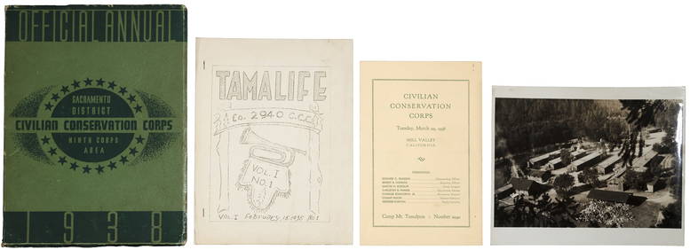
[Michigan ] 1879-1880 Iron Cliffs Co. Bonds (3)Grant Zahajko Auctions, LLC4.7(1k)See Sold PriceMar 06, 2024


![MITCHELL, S[amuel] Augustus. County Map of Texas (1 of 1)](https://p1.liveauctioneers.com/514/10700/2579974_1_x.jpg?height=282&quality=70&version=1160418848)


![[Michigan ] 1879-1880 Iron Cliffs Co. Bonds (3) (1 of 2)](https://p1.liveauctioneers.com/5755/320282/172114288_1_x.jpg?height=282&quality=70&version=1708463029)
