SoldTwo engraved and hand-colored maps of Egypt1) J. Jansson; "Aegypti Recentior Descriptio …" (Amsterdam: 1666) about 16 X 20 in., p.m.; 2) J. Blaeu, "Nova Aegypti Tabula" circa 1670, about 17 1/4 X 20 1/2 in., p.m.; Property from the Hans GoedSee Sold Price
SoldPIETER SCHENK (Dutch, 1660-1719)PIETER SCHENK (Dutch, 1660-1719); Two hand-colored engraved maps: ''Haemisphae Latumau Spherarum'' and ''Haemisphae Graphicum Coeliet'' (framed); 16 3/4'' x 19 3/4'' (plate)See Sold Price
SoldJacques Nicolas Bellin MapsJacques Nicolas Bellin , "Plan de La Nouvelle Orleans" and "Carte des Embouchures du Mississipi", two hand-colored engraved maps, from Le Petit Atlas Maritime, 1764, 7 1/2 in. x 11 in., framed . ProveSee Sold Price
SoldMathew Carey, Two MapsMathew Carey, "Louisiana" and "Missouri Territory formerly Louisiana", Philadelphia, 1814, two hand-colored engraved maps from General Atlas, the first world atlas published in the US, 15 1/4 in. x 17See Sold Price
Sold(MAP) SEUTTER, MATTHAEUS A group of two hand-colo(MAP) SEUTTER, MATTHAEUS A group of two hand-colored engraved maps. Augsburg: [c. 1740 or later.] America Meridionalis per sua Renga Province. Hand-colored engraved map of South America. Nova Orbis siSee Sold Price
Sold(MAP) VISSCHER, NICOLAUS. A group of 2 maps, 1678.(MAP) VISSCHER, NICOLAUS A group of two hand-colored engraved maps, [Amsterdam, c. 1678] Magnae Britanniae Tabula, with engraved cartouche featuring Hercules slaying cerebus to the right and an armoriSee Sold Price
SoldFour New York maps including hand colored lithographFour New York maps including hand colored lithograph "New York City, Brooklyn, Jersey City, Hoboken, etc." published by G. Woolworth Colton, two hand colored engraved maps of Yonkers "Westchester Co.See Sold Price
SoldNorth America. Nicolas Sanson d'Abbeville (1600-16North America. Nicolas Sanson d'Abbeville (1600-1667) L'Amerique Septentriolae Divisee en ses Prinipales Parties. Amsterdam: Hubert Jaillot, 1692. Large hand-colored engraved map, two sheets pasted toSee Sold Price
SoldJEFFERYS, THOMAS. An Exact Chart of the RiverJEFFERYS, THOMAS. An Exact Chart of the River St. Laurence. Two-sheet engraved map, 600x955 mm, ample margins; hand-colored in outline. London: Sayer, 1775 The fifth state, with the Sayer imprint beloSee Sold Price
SoldTwo Framed Hand-colored Engraved Maps, 19th/20thTwo Framed Hand-colored Engraved Maps, 19th/20th Century, Including a map of Morea olim Peloponnesus by Gerardus Mercator and of Deventer by Johannes Blaeu. Largest framed dimensions: h: 21 1/2 x w: 2See Sold Price
SoldHerman Moll hand colored copper engraved map (twoHerman Moll hand colored copper engraved map (two sheets joined together) Map of East Indies and the Adjacent Countries, with the Settlement's Factories and Territories Explaining what belongs to EnSee Sold Price
SoldTwo 17th Century Maps, Spain and MoroccoTwo framed, two page, hand colored, engraved maps, one is from an atlas by Willem and Joan Blaeu, titled "Legionis Regnum et Asturiarum Principatus", the other is from an atlas by Jan Jansson, drawn bSee Sold Price
SoldGrp: 2 Maps Sardinia and Sicily Giacomo GastaldiTwo copies of "Tavola Nuova di Sardigna et di Sicilia," from Giacomo (Jacopo) Gastaldi's (ca. 1500-1566) 1548 edition of Ptolemy. Two engraved maps of Sardinia and Sicily, Italy, one hand colored. DimSee Sold Price
SoldHERMAN MOLL HAND COLORED ENGRAVED MAPS 18TH C. TWOHERMAN MOLL, HAND COLORED ENGRAVED MAPS, 18TH C., TWO, GREAT BRITAIN, IRELAND, GALLOWAY:Under glass and matted in matched frames. Lyons Ltd., Antique Prints label. Visible image size 7 3/4" x 10 1/4".See Sold Price
SoldTWO ANTIQUE FRENCH HAND-COLORED ENGRAVED MAPSfrom Atlas National Illustre', one depicting the Ain region of France, the other the general areas of Paris and the Seine river, detailing the areas boundaries, vital statistics and commerce, both witSee Sold Price
SoldGroup of Two Maps of the United States, each a haGroup of Two Works A. American School, 19th Century Map of Florida Hand-colored engraving, 1855, published by J.H. Coulton & Co.; apparently in good condition. Framed.* Sight sizSee Sold Price
SoldFINLEY, ANTHONY. Composite Atlas with title: "FINLEY, ANTHONY. Composite Atlas with title: "Southern & Western States with Virginia, Pennsylvania & New Jersey. Anthony Finley. 1824." 21 hand-colored engraved maps from the two 1824 editions of FinSee Sold Price
SoldJan Jansson (Dutch, 1588-1664)Jan Jansson (Dutch, 1588-1664), "Somersettensis Comitatus Somerset Shire" and "Suthsexia vernacule Sussex", c. 1650, two hand-colored engraved copperplate maps, from the Atlas Noveus, with beautiful cSee Sold Price
SoldHand Colored Engraved Map,Hubert JaillotAfter Hubert Jaillot (1632-1712) "Amerique Septentrionale divisee on ses principales parties". Hand colored engraved map of North American under the French power of Louis XIV. [Sight: 22 1/2" H x 35"See Sold Price
Sold[Battle of New Orleans Map][Battle of New Orleans Map] , "Plan of an Attack made by the British Forces on the American Lines in Advance of Orleans on the 8th January 1815", engraved map, hand-colored in blue and red, ND but c.See Sold Price
SoldPinkerton's Polynesia from Dobson in Phil. 1818Heading: Author: Pinkerton, John Title: Polynesia Place Published: Philadelphia Publisher:Dobson Date Published: [1818] Description: Copper-engraved map, hand-colored. 50x6See Sold Price
SoldMap of North America c.1750Title: North America Author: Jefferys, Thomas Description: Copper-engraved map, hand-colored (later). 18x23 cm. (7x9").Little map of North America with pictorial cartouche featuring Native Americans iSee Sold Price
SoldGall & Inglis Map of N. AmericanGall and Inglis, Scottish, fl. 1810-1960. Engraved map with hand colored accents is entitled "Gall & Inglis' Map of North America 1850". Not examined out of the frame. Some creasing and toning. ImageSee Sold Price
SoldMitchell: County Map of Texas, 1862County Map of Texas, S. Augustus Mitchell, 1862. 10.75 x 13.375 inches. Steel engraved map, with hand colored wash and outlines. Inset map of Galveston Bay, and Vicinity. Colored by county and territoSee Sold Price
17th Century Hand Colored Engraved Map of GermanyGlobal Auctions Company4.3(36)See Sold PriceMar 03, 2024
Wilson - Wood Thrush, Red-breasted Thrush or Robin, & Nuthatches. 2Trillium Antique Prints & Rare Books4.5(30)See Sold PriceFeb 24, 2024
Wilson - Grosbeak, Warbler, Siskin, & Flycatcher. 17Trillium Antique Prints & Rare Books4.5(30)See Sold PriceFeb 24, 2024
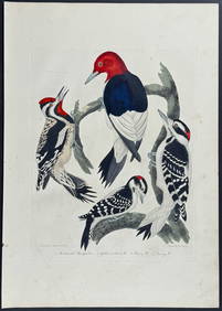
Wilson - Woodpeckers - Red-headed, Yellow-bellied, Hairy, & Downy. 9Trillium Antique Prints & Rare Books4.5(30)See Sold PriceFeb 24, 2024
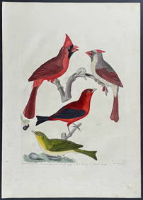
Wilson - Cardinal Grosbeak & Red Tanager. 11Trillium Antique Prints & Rare Books4.5(30)See Sold PriceFeb 24, 2024
Wilson - Mottled Owl, Lark, Creeper, & Warbler. 19Trillium Antique Prints & Rare Books4.5(30)See Sold PriceFeb 24, 2024
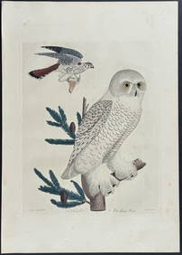
Wilson - Snow Owl (Snowy Owl) & Sparrow Hawk. 32Trillium Antique Prints & Rare Books4.5(30)See Sold PriceFeb 24, 2024
Wilson - Ivory-billed Woodpecker, Red-headed & Pileated Woodpeckers. 29Trillium Antique Prints & Rare Books4.5(30)See Sold PriceFeb 24, 2024
Wilson - Carolina Parrot & Flycatchers. 26Trillium Antique Prints & Rare Books4.5(30)See Sold PriceFeb 24, 2024


![[Battle of New Orleans Map] (1 of 6)](https://p1.liveauctioneers.com/268/176988/89092166_1_x.jpg?height=282&quality=70&version=1599167660)