Mount & Page, Virginia, Maryland, Pennsilvania, East &MOUNT & PAGE. Virginia, Maryland, Pennsilvania, East & West New Jersey. London: Mount & Page, c. 1773. Engraved, uncolored. 22 ¼ x 33 ¼ inches (unframed). An important navigational chart of the ChesSee Sold Price
SoldMOUNT & PAGE. Virginia, Maryland, PennsilvaniaMOUNT & PAGE. Virginia, Maryland, Pennsilvania, East & West New Jersey. Engraved folding two-sheet map joined, 510x805 mm, ample margins; repaired tear and abrading to map surface along right edge (75See Sold Price
SoldTHORNTON, John and William FISHER (after). VirginiTHORNTON, John and William FISHER (after). Virginia, Maryland, Pennsilvania, East & West New Jersey.London: Mount & Page, [c. 1743 or later]. Engraved map (510 x 805 mm). Condition: tissue-bSee Sold Price
SoldGrierson - Virginia, Maryland, etc.George Grierson (ca.1678 - 1753), after work by John Thornton (1641 - 1708) Virginia; Maryland; Pennsilvania; East & West; New Jarsey; Dublin Sold by Geo. Grierson; at the Two Bibles in Essex Street,See Sold Price
Sold[The English Pilot]. [John Thornton and William[The English Pilot]. [John Thornton and William Fisher]. See Sold Price
Mount & Page: Antique Map of East Coast of England 1740A chart for the Newcastle Trade describing the sea coasts of England from the South Foreland to Newcastle with the soundings, sands, shoals, harbours, buoys, beacons and seamarks, upon ye said coasts.See Sold Price
MAP: United States - East Coast. Maryland - Virginia Chesapeake BayDescription: United States - East Coast. Maryland - Virginia Chesapeake Bay. Smith Point to Cove Point. Published at Washington D.C. US Department of Commerce, National Oceanic Service. Measurement apSee Sold Price
SoldZatta. IL MARYLAND, IL JERSEY MERIDIONALE... Map.[United States] Antonio Zatta. IL MARYLAND, IL JERSEY MERIDIONALE, LA DELAWARE, E LA PARTE ORIENTALE DELLA VIRGINIA, E CAROLINA SETTENTRIONALE. Double-page engraved map of Virginia, Maryland, DelawareSee Sold Price
NOAA Nautical Chart/Ocean Survey Chesapeake BayNOAA formally C. & G.S.,United States - East Coast Maryland - Virginia "CHESAPEAKE BAY SMITH POINT TO COVE POINT", stamped upper center 1st Ed., July 1913 D-1954 -8418. Stamped lower right 12230 (formSee Sold Price
Sold''Carte de la Caroline... Virginie,'' [late 1790'[United States: Mid-Atlantic]. Tardieu. Carte De La Caroline Meridionale Et Septentrionale Et De La Virginie. Double-page engraved map of Virginia, Maryland, Delaware, and the Carolinas. ''P.F. TardieSee Sold Price
Mount & Page: Antique Coast Profile of East Scotland[A new description of the East Coast of Scotland]' The following places are shown or referred to on the coastal profile chart: Tantaland (Tantallon) Bass Rock Isle of May Bowens Boddam Peterhead New ASee Sold Price
Mount & Page: Antique Map of England East Coast, 1740TITLE/CONTENT OF MAP: 'A chart for the Newcastle Trade describing the sea coasts of England from the South Foreland to Newcastle with the soundings, sands, shoals, harbours, buoys, beacons and seamarkSee Sold Price
SoldCARY, JOHN. A New Map of Part of the United StCARY, JOHN. A New Map of Part of the United States of North America, exhibiting the Western Territory, Kentucky, Pennsylvania, Maryland, Virginia &c. Double-page engraved map, 520x600 mm, wide marginsSee Sold Price
SoldCARY, JOHN. A New Map of Part of the United States ofCARY, JOHN. A New Map of Part of the United States of North America, Exhibiting the Western Territory, Kentucky, Pennsylvania, Maryland, Virginia &c. Double-page engraved map of the Great Lakes and WeSee Sold Price
North Sea Coast ChartNORTH SEA coast chart. East Anglia Holland Flanders. MOUNT/PAGE/COLLINS 1771 map Size: Approx 46.0 x 57.5cm, 18 x 22.5 inches (Large); Please note that this is a folding map. Please note that this lotSee Sold Price
SoldJohann Baptist Homann map of Virginia, Maryland"VIRGINIA MARYLANDIA et CAROLINA" by Johann Baptist Homann, 1714. Colored areas include Virginia, Carolina, Maryland, West New Jersey, and East New Jersey. State lines colored. Important settlements mSee Sold Price
SoldSPEED, JOHN. A Map of Virginia and Maryland.SPEED, JOHN. A Map of Virginia and Maryland. Double-page engraved map, 385x500 mm, wide margins, English text on verso; browned along the fold and at sheet edges, 60-mm chip in right margin extendingSee Sold Price
SoldSPEED, JOHN. A Map of Virginia and Maryland.SPEED, JOHN. A Map of Virginia and Maryland. Double-page engraved map, 385x500 mm, wide margins, English text on verso; minor browning along the fold and in margins, few nicks at edges. Not a strong iSee Sold Price
SoldSpeed--- A Map of Virginia and Maryland ca. 1676[Virginia]. John Speed. A Map Of Virginia And Maryland. Double-page map engraved by F. Lamb. Lon: Thomas Bassett and Richard Chiswell. 14 7/8 x 19 1/2 inches. Oriented to the West. 9th and last majorSee Sold Price
SoldSpeed: Map of Virginia and Maryland, 1676[Virginia]. John Speed. A Map Of Virginia And Maryland. Double-page map engraved by F. Lamb. Lon: Sold by Thomas Bassett and Richard Chiswell, [1676]. 14 5/8 x 19 1/8 inches. Oriented to the West. TexSee Sold Price
Sold18TH CENTURY VIRGINIA AND MARYLAND MAP18TH CENTURY VIRGINIA AND MARYLAND MAP, double-page hand-colored engraved folio, titled "Carte de la Virginie et du Maryland", Robert de Vaugondy, Paris. Based on a map by Joshua Fry and Peter JeffersSee Sold Price
The Channel and City of DublinThe Channel and City of Dublin, Mount and page, circa 1740, Chart of the east coast of Ireland with large inset showing Dublin Harbour with city planSee Sold Price
Collins: Map of East Kent Coast. Dover-thanet, 1774Map: A Large Chart of the Downs, shewing the sands, shoals, depths of water & anchorage with all the leading marks to avoid dangers. Sold by Mount & Page, Tower Hill, London. The chart, which is orienSee Sold Price
SoldA New Map of Virginia Maryland...[Revised Description][Virginia/Maryland] A NEW MAP OF VIRGINIA MARYLAND AND THE IMPROVED PARTS OF PENNSYLVANIA AND NEW JERSEY. Engraved map, uncolored, 19 1/8 x 21 7/8 in., double-page. 2nd state: FirSee Sold Price
Charles Russell Train (DC,MD,1879-1968) oil paintingBroward Auction Gallery4.8(277)See Sold PriceMar 10, 2024
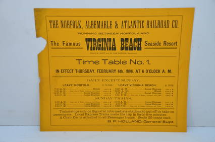
Norfolk Albemarle and Atlantic RR February 1896 Public TimetableJM Hobby Supply and Railroad Artifact Auctions4.4(126)See Sold PriceFeb 24, 2024
New York Central RR Wall Mount LampJM Hobby Supply and Railroad Artifact Auctions4.4(126)See Sold PriceFeb 24, 2024
BOTH TITLE PAGES OF COLLINS" COASTAL SURVEY, 1776, IN MATCHING FRAMESThomaston Place Auction Galleries4.4(386)See Sold PriceFeb 24, 2024
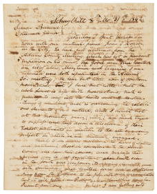
[CIVIL WAR]. BUTLER, Benjamin Franklin (1818-1893). Secreta...Potter & Potter Auctions4.6(539)See Sold PriceMar 07, 2024
[BASEBALL]. Original Photographic Team Portrait of the East...Potter & Potter Auctions4.6(539)See Sold PriceMar 07, 2024
[NEW YORK STATE]. Scrapbook of photographs of Lake George a...Potter & Potter Auctions4.6(539)See Sold PriceMar 07, 2024
[ENSLAVEMENT & ABOLITION]. CDV of Rev. Josiah Henson, the "Original 'Uncle Tom.'" Philadelphia, PA:Freeman's | Hindman4.4(1.6k)See Sold PriceFeb 27, 2024
Lot of 12 Vintage 1953 & 1954 General Mills Promotional Tin License PlatesBodnar's Auction Sales4.6(609)See Sold PriceMar 28, 2024
NORTH AFRICA. 'Biledulgerid', a former North African country. MALLET 1683 mapJasper524.5(9.8k)See Sold PriceFeb 28, 2024
Baltimore Classical Giltwood Mirror with Reproduction MateBrunk Auctions4.6(463)See Sold PriceMar 08, 2024
Two Books About George WashingtonRapid Estate Liquidators and Auction Gallery4.5(1.1k)See Sold PriceMar 01, 2024
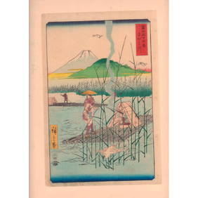
Hiroshige (Japanese, 1797-1858) Woodblock Print, SagamigawaLion and Unicorn4.7(1.8k)See Sold PriceMar 14, 2024


![[The English Pilot]. [John Thornton and William (1 of 1)](https://p1.liveauctioneers.com/906/39074/16758164_1_x.jpg?height=282&quality=70&version=1364588521)


![[CIVIL WAR]. BUTLER, Benjamin Franklin (1818-1893). Secreta... (1 of 2)](https://p1.liveauctioneers.com/928/318880/171360942_1_x.jpg?height=282&quality=70&version=1707501302)
![[BASEBALL]. Original Photographic Team Portrait of the East... (1 of 1)](https://p1.liveauctioneers.com/928/318880/171361392_1_x.jpg?height=282&quality=70&version=1707501302)
![[NEW YORK STATE]. Scrapbook of photographs of Lake George a... (1 of 5)](https://p1.liveauctioneers.com/928/318880/171361558_1_x.jpg?height=282&quality=70&version=1707501302)

![[ENSLAVEMENT & ABOLITION]. CDV of Rev. Josiah Henson, the "Original 'Uncle Tom.'" Philadelphia, PA: (1 of 2)](https://p1.liveauctioneers.com/197/319238/171467958_1_x.jpg?height=282&quality=70&version=1707520367)