Sold1818 A CORRECT MAP OF VIRGINIA By M. Carey + SonsHistoric Maps 1818 “A CORRECT MAP OF VIRGINIA” By M. Carey 1818 Hand-Colored Copper Plate Engraved Map titled, “A CORRECT MAP OF VIRGINIA” Published by M. Carey & Sons, Philadelphia, Framed, CSee Sold Price
Sold1818 A CORRECT MAP OF VIRGINIA By M. Carey + SonsHistoric Maps 1818 “A CORRECT MAP OF VIRGINIA” By M. Carey 1818 Hand-Colored Copper Plate Engraved Map titled, “A CORRECT MAP OF VIRGINIA” Published by M. Carey & Sons, Philadelphia, Framed, CSee Sold Price
Sold1818 “A CORRECT MAP OF VIRGINIA” By M. CareyHistoric Maps 1818 “A CORRECT MAP OF VIRGINIA” By M. Carey 1818 Hand-Colored Copper Plate Engraved Map titled, “A CORRECT MAP OF VIRGINIA” Published by M. Carey & Sons, Philadelphia, Framed, CSee Sold Price
SoldBirbeck, Morris Letters from IllinoisPhil; M. Carey & Son 1818, 2nd Edition 126 pp. 2 folding maps; Birbeck founded the town of New Albion, Illinois. This book of letters to friends in England contains information regarding economic andSee Sold Price
SoldLetters from Illinois, Morris Birkbeck 1818Heading: Author: Birkbeck, Morris Title: Letters from Illinois Place Published: Philadelphia Publisher:M. Carey and Son Date Published: 1818 Description: xvii, [1], 126 pp.See Sold Price
Letters from Illinois, Morris Birkbeck 1818Heading: Author: Birkbeck, Morris Title: Letters from Illinois Place Published: Philadelphia Publisher:M. Carey and Son Date Published: 1818 Description: xvii, [1], 126 pp.See Sold Price
SoldM L Weems THE LIFE OF GEORGE WASHINGTON WITH CURIOUSM L Weems THE LIFE OF GEORGE WASHINGTON WITH CURIOUS ANECDOTES 1820 Leatherbound Gilt Engraved Illustrated Plates Fold-Out Map M Carey and Sons Intact Portrait History Biography United States GeneralSee Sold Price
SoldHAND COLORED ATLAS MAP BOOK 1821 M. CAREY & SONSAntique Atlas with hand coloring. Published by M. Carey & Sons, Philadelphia. Titled, "Ancient and Modern History of the Principal Royal Family. Leather corners and spine with some bends, some toningSee Sold Price
SoldNORFOLK, VIRGINIA ENGRAVINGNORFOLK, VIRGINIA ENGRAVING, faded color, titled "Norfolk: From Gosport, Virginia", published by M. Carey & Son, Philadelphia, engraved by John Hill (1770-1850), after Joshua Shaw. Matted, not framed.See Sold Price
Sold1820 M. Carey & Son Map of IrelandDESCRIPTION: 1820 Matthew Carey & Son map of Ireland drawn for the illustration of Lavoisne's Genealogical Historical Chronological and Geographical Atlas by J. Aspin. In a green mat with a gilt frameSee Sold Price
Sold1 vol. (Bible in English.) The Holy Bible, contai1 vol. (Bible in English.) The Holy Bible, containing the Old and New Testaments. Philadelphia: M. Carey & Son, 1818. 2 vols. in 1. 12mo, contemp. sheep; scuffed, occasionally rubbed. Early owner's inSee Sold Price
SoldM. Carey & Son STATISTICAL MAP ... OF IRELAND 1820[Ireland/Carey & Son] Geographical and Statistical Map of Ireland. Ireland; Drawn from the Best Authorities. "For the illustration of Lavoisne's Genealogical, historical, chronological & geographicalSee Sold Price
SoldBARTON. Vegetable Materia Medica. 1817-18BARTON, William P. C. (1786-1856) Vegetable Materia Medica of the United States; or Medical Botany. Philadelphia: M. Carey & Son, 1817-1818. Two volumes in one. Quarto (11 x 8 ¾ inches, 275See Sold Price
SoldBARTON. Vegetable Materia Medica of the United StaBARTON, William P. C. Vegetable Materia Medica of the United States; or Medical Botany. Philadelphia: M. Carey & Son, 1817-1818. 2 vols in 1. Quarto (275x220 mm). 50 hand-colored engravedSee Sold Price
Sold3 COLORED ANTIQUE MAPS OF TURKEY, 2 BY M. CAREY3 HAND COLORED ANTIQUE MAPS OF TURKEY, 2 BY M. CAREY & SON, 20" X 16" & 1 BY JOHNSON, 12" X 16":The larger ones with center folds; Johnson map is c. 1860; all framed.See Sold Price
SoldGEOGRAPHICAL & STATISTICAL MAPS OF DENMARK, SWEDEN & NODenmark, Sweden and Norway after the fall of Napolean 1820 by M. Carey & Son, hand-colored map surrounded by statistical data. Sight size 17 x 21 inches, overall 26.75 x 29.See Sold Price
SoldGEOGRAPHICAL & STATISTICAL MAP OF RUSSIA 1820The Russian Empire after the fall of Napolean 1820 by M. Carey & Son, hand-colored map surrounded by statistical data. Sight size 16.5 x 21 inches, overall 26.75 x 29.See Sold Price
SoldPETERSBURG, VIRGINIA HAND-COLORED PRINTPETERSBURG, VIRGINIA HAND-COLORED PRINT, titled "Bolling's Dam, Petersburgh Virginia." in margin, above "Published by M. Carey & Son Philadelphia.", conservation framing. Mid 19th century. 11 1/2" x 1See Sold Price
Geographical and Statistical Map of Russia, 1820Map: Geographical and Statistical Map of Russia. Publication Date: 1820 Authors: M. CAREY & SON, GROS, C. Publisher: M. CAREY & SON Size: Quarto – 10.25 H x 15.25 W Inches "Map of the Russian EmpireSee Sold Price
Sold1820 HISTORICAL MAP OF THE ROMAN EMPIRE BY M. CAREY & SHistorical map of the Roman empire by M. Carey and Son, Phila. Matted, 16.75 x 20.75 inch sight size. Not examined outside of wrappings, appears good, crease and some toning.See Sold Price
Sold1818 MAP OF NEW SOUTH WALES, AUSTRALIAWith insets of Howes' and Norfolk Islands. From M. Carey's General Atlas. Professionally matted, 11.25 x 9.25 inch sight size.See Sold Price
Sold1821 Carey & Lea Map of North and South America1821 Carey & Lea map of North and South America. 1821 Geographical, Historical, and Statistical Map of America. from the third Philadelphia Edition. Printed by T. H. Palmer for M. Carey & Son, from thSee Sold Price
SoldAntique Map of the Incursions of the Barbarians, 1820Map: Geographical and Historical Map of the Incursions of the Barbarians. Publication Date: 1820 Authors: THOM. H. PALMER, FOR M. CAREY & SON, GROS, C. Publisher: THOM. H. PALMER, FOR M. CAREY & SON SSee Sold Price
SoldThom. H. Palmer: Map of the Roman Empire, 1820Map: Map of the Roman Empire Maker: Thom. H. Palmer, for M. Carey & Son, Gros, C. Size: Quarto - 10.75 H x 15.00 W Inches "Intended for the Elucidation of Lavoisne's historical atlas. By C. Gros. 1820See Sold Price
19th Century Historical Plate "VU DU CHATEAU ERMENONVILLE" 10 1/4 CA 1830Rbfinearts4.4(575)See Sold PriceFeb 24, 2024
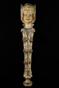
ILLIONS SUPREME CAROUSEL FIGURAL DIVIDER PANELJohn McInnis Auctioneers,LLC4.6(504)See Sold PriceFeb 25, 2024
1937 Holland, Michigan, Tulip Time Map Guide, FramedLakeshore Event Center4.6(105)See Sold PriceMar 02, 2024
Portfolio of 15 County Maps by Robert Morden (English 1650-1703)Nadeau's Auction Gallery4.7(405)See Sold PriceFeb 24, 2024
1818 RARE Geography Made Easy MAPS Jedidiah Morse Boston Indians Atlas AsiaSchilb Antiquarian Rare Books4.8(422)See Sold PriceMar 31, 2024
W.M. Porter & Sons Nickel Plated Railroad Conductors LanternRail & Road Auctions4.6(165)See Sold PriceMar 08, 2024
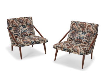
A pair of Gio Ponti for M. Singer and Sons lounge chairsJohn Moran Auctioneers, Inc.4.7(459)See Sold PriceFeb 27, 2024
6 Vintage Childrens Books - Hardbacks - Whinney the Pooh, Johnny AppleseedNorth American Artifact Auctions4.6(184)See Sold PriceApr 20, 2024
[LITHOGRAPHY]. [GEO. S. HARRIS & SONS CIGAR BOX LABELS & TR...Potter & Potter Auctions4.6(544)See Sold PriceMar 07, 2024
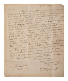
RANDOLPH, Thomas Mann (1768-1828), Virginia Governor and Thomas Jefferson's son-in-law. AutographFreeman's | Hindman4.4(1.6k)See Sold PriceFeb 27, 2024
JOHN J. AUDUBON (1785-1851) LITHOGRAPH, 1948, 19IN x 25IN (48cm x 64cm)The Rug Life4.3(12)See Sold PriceMar 07, 2024
Carey, pub. 1796 - Map of GeorgiaTrillium Antique Prints & Rare Books4.5(30)See Sold PriceFeb 24, 2024
Carey, pub. 1796 - Map of The State of South CarolinaTrillium Antique Prints & Rare Books4.5(30)See Sold PriceFeb 24, 2024
Carey, pub. 1796 - Map of KentuckyTrillium Antique Prints & Rare Books4.5(30)See Sold PriceFeb 24, 2024
Carey, pub. 1796 - Map of the Tennassee State formerly part of North Carolina (Tennessee)Trillium Antique Prints & Rare Books4.5(30)See Sold PriceFeb 24, 2024
Buckinghamshire local interest : a quantity of Victorian and later mounted monochrome photographsClaydon Auctioneers Ltd4.3(125)See Sold PriceFeb 26, 2024
1816 MAP SOUTHERN PART OF RUSSIA or MUSCOVY in EUROPE copper engraving ANTIQUEJasper524.5(9.8k)See Sold PriceFeb 27, 2024
1816 MAP NORTHERN PART OF RUSSIA or MUSCOVY in EUROPE copper engraving ANTIQUEJasper524.5(9.8k)See Sold PriceFeb 27, 2024
New and Correct Map of North America With the West India Islands,Jasper524.5(9.8k)See Sold PriceFeb 27, 2024
5 Reference Books on Pre-Columbian Archeology & ArtArtemis Fine Arts4.8(1.4k)See Sold PriceFeb 26, 2024
"Map of the Parishes of Iberville Most of West Baton Rouge and Including Parts of the Parishes ofCrescent City Auction Gallery4.3(231)See Sold PriceMar 09, 2024


![[LITHOGRAPHY]. [GEO. S. HARRIS & SONS CIGAR BOX LABELS & TR... (1 of 1)](https://p1.liveauctioneers.com/928/318880/171361059_1_x.jpg?height=282&quality=70&version=1707501302)