SoldLarge silk print of maps of the world, a collectioLarge silk print of maps of the world, a collection of Kensitas cigarette silks printed with world flags, an Errimar stamp album and a collection of loose ephemeraSee Sold Price
SoldNEEDLE WORK WORLD MAP SAMPLERNEEDLE WORK WORLD MAP SAMPLER, H 18", W 27":Silk on silk embroidery and print on silk. On stretcher, 18" x 25". Printed in ink. Late 18th c.See Sold Price
SoldLarge Continental northern world Celestial mapLarge Continental northern world Celestial map, 20th c., print on paper, 72.5"h x 68"w (sight), matted and framed under glass Provenance: Ford Foundation Collection - The Ford Foundation, establishedSee Sold Price
SoldOLIVER for HERMES "LES AMERIQUES" SCARF, FRANCE, 1992Silk twill w/ multi-color print, Christopher Columbus, Native Americans & animals in front of world map, design by "Kermit Oliver", 34" x 35", (round discolored area at center top edge) very good.See Sold Price
SoldVintage Piscator World Map silk embroideryVintage Piscator World Map silk embroidery. This is not a print or etching. It is a rare multimedia on silk embroidery including gold leaves after 17th century Commander's Map. In a mahogany frame witSee Sold Price
SoldGross, Alexander 1920 Large Map. World HemispheresLarge Lithograph Map Published 1920, London for "The Daily Telegraph Victory Atlas of the World" by Alexander Gross. Centre fold as published. Paper Size: 25 x 19.5 inch (64 x 49cm) Good ConditionSee Sold Price
SoldBartholomew, John 1922 Large Map of LondonLarge Lithograph Map Published 1922 by The Times, London for "The Times Survey Atlas of the World" Maps by John George Bartholomew of the Edinburgh Geographical Institute. Centre fold as issued. PaperSee Sold Price
SoldBartholomew, John 1922 Large Map of the North PoleLarge Lithograph Map Published 1922 by The Times, London for "The Times Survey Atlas of the World" Maps by John George Bartholomew of the Edinburgh Geographical Institute. Centre fold as issued. PaperSee Sold Price
SoldBartholomew, John 1922 Lot of 4 Large Maps of AfricaCentral Africa - East and West, Egypt and North West Africa. Large Lithograph Maps Published 1922 by The Times, London for "The Times Survey Atlas of the World" Maps by John George Bartholomew of theSee Sold Price
SoldGross, Alexander 1920 Lot of 4 Large World MapsIncl Time Zones, Wind, Production and Religions/Races. Large Lithograph Maps Published 1920, London for "The Daily Telegraph Victory Atlas of the World" by Alexander Gross. Centre fold as published. PSee Sold Price
SoldBartholomew, John 1922 Lot of 4 Large Maps of EuropeLarge Lithograph Maps Published 1922 by The Times, London for "The Times Survey Atlas of the World" Maps by John George Bartholomew of the Edinburgh Geographical Institute. Centre fold as issued. PapeSee Sold Price
SoldLarge ms. Japanese World MapHeading: (World) Author: Title: [Manuscript World map] Place Published: Publisher: Date Published: No date [19th century] Description: Ink on paper, backed with silk. 135.See Sold Price
SoldBartholomew, John 1922 Large Map of New ZealandLarge Lithograph Map Published 1922 by The Times, London for "The Times Survey Atlas of the World" Maps by John George Bartholomew of the Edinburgh Geographical Institute. Centre fold as issued. PaperSee Sold Price
SoldBartholomew, John 1922 Group of 3 Large Maps of ChinaLarge Lithograph Map Published 1922 by The Times, London for "The Times Survey Atlas of the World" Maps by John George Bartholomew of the Edinburgh Geographical Institute. Centre fold as issued. PaperSee Sold Price
SoldBartholomew, John 1922 Lot of 4 Large World MapsPopulation, Commerce, Vegetation/Ocean Currents, and Bathy-Orographical. Large Lithograph Maps Published 1922 by The Times, London for "The Times Survey Atlas of the World" Maps by John George BartholSee Sold Price
SoldBartholomew, John 1922 Pair of Large Maps of JapanLarge Lithograph Map Published 1922 by The Times, London for "The Times Survey Atlas of the World" Maps by John George Bartholomew of the Edinburgh Geographical Institute. Centre fold as issued. PaperSee Sold Price
SoldBartholomew, John 1922 Pair Large Maps of East Indies"Farther India" showing Siam, Indonesia, Singapore, Malaysia. Together with "Malay Archipelago" Large Lithograph Map Published 1922 by The Times, London for "The Times Survey Atlas of the World" MapsSee Sold Price
SoldBartholomew, John 1922 Lot of 4 Maps. Oceans & WorldIncl North & South Atlantic, Indian Ocean and World Commerce. Large Lithograph Maps Published 1922 by The Times, London for "The Times Survey Atlas of the World" Maps by John George Bartholomew of theSee Sold Price
SoldBartholomew, John 1922 Lot of 5 Large Maps of FranceLarge Lithograph Maps Published 1922 by The Times, London for "The Times Survey Atlas of the World" Maps by John George Bartholomew of the Edinburgh Geographical Institute. Centre fold as issued. PapeSee Sold Price
SoldMexico 1920-22 Pair of Large Maps by Gross, BartholomewLarge Lithograph Maps Published 1920, London for "The Daily Telegraph Victory Atlas of the World" by Alexander Gross and 1922 by The Times, London for "The Times Survey Atlas of the World" Maps by JohSee Sold Price
SoldBartholomew, John 1922 Lot of 4 Large UK MapsLarge Lithograph Maps Published 1922 by The Times, London for "The Times Survey Atlas of the World" Maps by John George Bartholomew of the Edinburgh Geographical Institute. Centre fold as issued. PapeSee Sold Price
SoldBartholomew, John 1922 Lot of 4 Large Maps of AfricaCentral Africa - East and West, Egypt and North West Africa. Large Lithograph Maps Published 1922 by The Times, London for "The Times Survey Atlas of the World" Maps by John George Bartholomew of theSee Sold Price
SoldBartholomew, John 1922 Lot of 8 Large Maps of CanadaLarge Lithograph Maps Published 1922 by The Times, London for "The Times Survey Atlas of the World" Maps by John George Bartholomew of the Edinburgh Geographical Institute. Centre fold as issued. PapeSee Sold Price
SoldBartholomew, John 1922 Lot of 5 Large Maps of FranceLarge Lithograph Maps Published 1922 by The Times, London for "The Times Survey Atlas of the World" Maps by John George Bartholomew of the Edinburgh Geographical Institute. Centre fold as issued. PapeSee Sold Price
HERMES Muffler/Scarf Large Pink White Square Print Silk Carre90 LIBERTE EGALITE FRATERNITEBidhaus4.3(773)See Sold PriceFeb 26, 2024
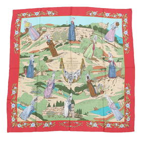
HERMES Muffler/Scarf Large Silk Red Beige Square Print Carre90 COSTUMES DES DEPARTEMENTS DepartmentBidhaus4.3(773)See Sold PriceFeb 29, 2024
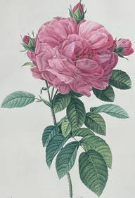
Redoute, Rare, Large Folio - Rose - Rosa Gallica flore giganteoTrillium Antique Prints & Rare Books4.5(33)See Sold PriceFeb 24, 2024
Framed Space Age Rand McNally Map of Planets Poster, 1958PUBLIC SALE4.7(227)See Sold PriceMar 02, 2024
Pre-SECOND WORLD WAR AFRICA. European colonies & German mandates 1942 old mapJasper524.5(9.9k)See Sold PriceFeb 28, 2024
World War 2 Europe Battle of the Atlantic 1939-43 Axis Expansion limits 1959 mapJasper524.5(9.9k)See Sold PriceFeb 28, 2024
Operation Torch Nov 1942-May 1943. World War 2. Western Mediterranean 1966 mapJasper524.5(9.9k)See Sold PriceFeb 28, 2024
A 19TH CENTURY JAPANESE MEIJI PERIOD WOODBLOCK PRINT together with a painted silk watercolour. LargeHannam's Auctioneers Ltd4.3(399)See Sold PriceFeb 29, 2024
Henri-Joseph Redouté - Large Folio Botanical Print - Plants in Egypt - Fagonia latifoliaProverde Auctions4.3(3)See Sold PriceFeb 28, 2024
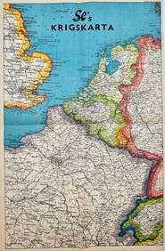
Vintage Map - Krigskarta - War Map - Second World War, published 1940Proverde Auctions4.3(3)See Sold PriceFeb 28, 2024