SoldBritish Admiralty.- - A group of 57 admiralty charts ofincluding Beira Harbour, Mouths of the River Kwara or Niger, Zanzibar Harbour, Algoa Bay, and others, engravings, lithographs, touches of hand-colouring, manuscript annotations, various sizes, largestSee Sold Price
SoldBritish Admiralty. a group of 13 coastal charts ofBritish Admiralty. a group of 13 coastal charts of the Eastern Mediterranean,8 single-page charts including Iskanderún, Latakiyah, Saida (Sidon), Sûr (Tyre), Acre, Haija and elsewSee Sold Price
British Admiralty charts of Japanese watersBritish Admiralty. a group of detailed naval charts of Japanese coastal waters and harbours,7 electrotyped charts, v.s., 510 x 695mm. to 1160 x 710mm., vertical folds, a few minor splits, surfSee Sold Price
South Pacific – Fiji Islands, Easren Group BritishTitle/Content of Map: South Pacific – Fiji Islands, Easren Group British Admiralty Chart 440, published 1883 Date: 1883 Cartographer: British Admiralty Material/Medium: thick paper Size: standard VeSee Sold Price
British Admiralty Charts.- - A group of 16 nauticallithographs, various sizes, largest c. 670 x 1180 mm., rolled, the majority backed with linen, one or two with discoloured varnish, occasional spotting, browning, rust spots, surface dirt, sheet loss,See Sold Price
SoldChina Sea.- a group of coastal chartsChina Sea.- a group of coastal charts,British Admiralty charts of the coasts of China, Korea, the Gulf of Thailand, the port of Saigon, and elsewhere, based on Japanese government charts fromSee Sold Price
Admiralty Charts.- [British Isles], - A group of19 lithographed electrotyped charts, folding, occasional points picked out in colour, some autograph notations, some spotting and light soiling mostly to margins, v.s ., 1920s-40s; sold not subject toSee Sold Price
SoldBritish Admiralty.- - A mixed group of 56 admiraltyincluding The Bay of Bengal, Trinidad Island, The Narrows and St George's Harbour, Bermuda, Port of Rangoon, New Zealand, Dublin, Mexico, and others, engravings, lithographs, touches of hand-colouringSee Sold Price
SoldScotland and North England.- Admiralty ChartsScotland and Northern England.- Admiralty Charts,A group of sea charts including Mull of Kintyre to Ardnamurchan, Loch Linnhe - Southern and Northern Parts, Aberdeen to Banff, Berwick to AberdSee Sold Price
Fiji Islands – Pacific Ocean British Admiralty ChartVery detailed, unused and authentic chart of Ngau Island and Mambulitha Reef in the Fiji or Viti Island Group. With beautiful view on the island. Authentic sea chart, no modern copy. On thick paper, fSee Sold Price
SoldAdmiralty Charts.-British Admiralty Charts.- 8 charts of Malaysia and Singapore,including Approaches to Singapore, Singapore Strait, Malacca Strait and elsewhere, first dated between 1898 and 1930, with correctSee Sold Price
Gulf of Mexico, West Indies and Caribbean Sea. from the Most Recent Spanish and British AdmiraltyPublication Date: 1870-07-01 Title: Gulf of Mexico, West Indies and Caribbean Sea. from the Most Recent Spanish and British Admiralty Charts. Sheet V. Cartographer: ANONYMOUS Publisher: U.S. NAVY. HYDSee Sold Price
British Admiralty Chart of San Francisco Harbor, 1885Map: 1885 British Admiralty Chart of San Francisco Harbor -- North America; West Coast; San Francisco Harbour from United States Coast Survey 1877 Cartographer: British Admiralty Year / Place: 1885, LSee Sold Price
1885 British Admiralty Chart of San Francisco Harbor --Title/Content of Map: 1885 British Admiralty Chart of San Francisco Harbor -- North America; West Coast; San Francisco Harbour from United States Coast Survey 1877 Date Printed: 1885, London CartograpSee Sold Price
SoldBritish Admiralty: Antique Chart of San FranciscoTitle/Content of Map: 1885 British Admiralty Chart of San Francisco Harbor -- North America; West Coast; San Francisco Harbour from United States Coast Survey 1877 Date Printed: 1885, London CartograpSee Sold Price
SoldUnited States – Nantucket Island British AdmiraltyTitle: United States – Nantucket Island British Admiralty Chart 2489, published 1896 Date: 1896 Cartographer: British Admiralty Size: 28x41 in Hardly used sea chart of the the treacherous coast ofSee Sold Price
SoldLarge British Admiralty chart of world, 1874Heading: Author: Carrington, R.C. Title: Chart of the World Place Published: London Publisher:Published by the Admiralty Date Published: 1874 Description: Engraved map. 70xSee Sold Price
United States – Nantucket Island, British AdmiraltyTitle: United States – Nantucket Island, British Admiralty Chart 2489, published 1896 Date: 1878 Cartographer: British Admiralty Materials: thick paper Size: standard 71x104 cm (28x41 in) AdditionalSee Sold Price
Crooked Island Passage Bahamas 1828 British Admiralty ChartScarce original 1828 British Admiralty Nautical Chart: A Survey of the Crooked Island Passage. By Mr. Anthony De Mayne, 1827 and 28. London Published according to Act of Parliament at the HydrographicSee Sold Price
Tasmania, Australia British Admiralty Chart 960,Title: Tasmania, Australia British Admiralty Chart 960, published 1889 Date: 1889 Cartographer: British Admiralty Material/Medium: thick paper Size: 28x48 in Very nice engraved, very detailed and unusSee Sold Price
Rio de la Plata, Uruguay British Admiralty Chart 3651,Title: Rio de la Plata, Uruguay British Admiralty Chart 3651, published 1906 Date: 1906 Cartographer: British Admiralty Material/Medium:thick paper Size:71x52 cm Additional Info:Hardly used, small scaSee Sold Price
Montevideo, Uruguay, Rio de la Plata British AdmiraltyTitle: Montevideo, Uruguay, Rio de la Plata British Admiralty Chart 2001, published 1895 Date: 1895 Cartographer: British Admiralty Material/Medium:thick paper Size:71x104 cm Additional Info:Unused, sSee Sold Price
Plans on the Coast of California, British AdmiraltyTitle: Plans on the Coast of California, British Admiralty chart 2885, published1923 Date: Published: 1923. Edition: 1994 Cartographer: British Admiralty Material/Medium: thick paper Size:standard 71xSee Sold Price
Korea – West Coast British Admiralty Chart 3699,Title/Content of Map: Korea – West Coast British Admiralty Chart 3699, published 1908 Date Printed: 1908 Cartographer: British Admiralty Material/Medium: thick paper Size: standard 71x104 cm (28x41See Sold Price
Natural History - British Promicroceras Fossil Ammonite GroupTimeLine Auctions Ltd.4.6(183)See Sold PriceMar 08, 2024
Natural History - British Fossil Belemnite GroupTimeLine Auctions Ltd.4.6(183)See Sold PriceMar 08, 2024
Natural History - British Promicroceras Fossil Ammonite GroupTimeLine Auctions Ltd.4.6(183)See Sold PriceMar 08, 2024
Natural History - British Microderoceras Fossil Ammonite GroupTimeLine Auctions Ltd.4.6(183)See Sold PriceMar 08, 2024
Natural History - British Promicroceras Fossil Ammonite GroupTimeLine Auctions Ltd.4.6(183)See Sold PriceMar 09, 2024
Natural History - British Promicroceras Fossil Ammonite GroupTimeLine Auctions Ltd.4.6(183)See Sold PriceMar 09, 2024
World Coins - British Empire - Mixed Pennies Group [6]TimeLine Auctions Ltd.4.6(183)See Sold PriceMar 09, 2024
Robert Herdman-Smith (British, 1879-1945), Group of Three Geishas Color Etchings, consisting of:Crescent City Auction Gallery4.3(231)See Sold PriceMar 01, 2024
[SHEET MUSIC]. A Group of Nearly 57 Sheet Music Pieces and ...Potter & Potter Auctions4.6(545)See Sold PriceMar 07, 2024
[CIGARETTE LEATHER CARDS]. A Group of 57 Leather Cards from...Potter & Potter Auctions4.6(545)See Sold PriceMar 07, 2024
Blur Damon Albarn Signed Vinyl LP Exact Photo ProofShakespeare Auctions4.3(1)See Sold PriceFeb 25, 2024
VARIOUS ARTISTS [BRITISH TRAVEL GUIDES]. Group of 6 map booklets and flyers. 1930s.Swann Auction Galleries4.4(70)See Sold PriceFeb 29, 2024
West Indies. South Coast of Jamaica from Port Royal to Pedro Bluff.Jasper524.5(9.9k)See Sold PriceFeb 27, 2024
Southern Africa Cape of Good Hope-Madagascar ADMIRALTY sea chart 1935 (1955) mapJasper524.5(9.9k)See Sold PriceFeb 28, 2024
Gulf of Guinea. Ghana Togo Benin Nigeria. ADMIRALTY sea chart 1928 (1954) mapJasper524.5(9.9k)See Sold PriceFeb 28, 2024
South Namibia coast. Walvis Bay-Orange River ADMIRALTY sea chart 1881 (1954) mapJasper524.5(9.9k)See Sold PriceFeb 28, 2024
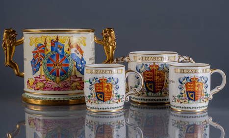
GROUP OF BRITISH ROYAL PORCELAIN MEMORABILIAPridham's Auctions & Appraisals4.7(223)See Sold PriceMar 02, 2024
British Mini Medal Group, Pip Squeak & WilfredRapid Estate Liquidators and Auction Gallery4.5(1.1k)See Sold PriceFeb 29, 2024


![World Coins - British Empire - Mixed Pennies Group [6] (1 of 1)](https://p1.liveauctioneers.com/1191/317894/170617541_1_x.jpg?height=282&quality=70&version=1706620797)


![[SHEET MUSIC]. A Group of Nearly 57 Sheet Music Pieces and ... (1 of 1)](https://p1.liveauctioneers.com/928/318880/171361496_1_x.jpg?height=282&quality=70&version=1707501302)
![[CIGARETTE LEATHER CARDS]. A Group of 57 Leather Cards from... (1 of 1)](https://p1.liveauctioneers.com/928/318880/171361526_1_x.jpg?height=282&quality=70&version=1707501302)


![VARIOUS ARTISTS [BRITISH TRAVEL GUIDES]. Group of 6 map booklets and flyers. 1930s. (1 of 2)](https://p1.liveauctioneers.com/199/319703/171640571_1_x.jpg?height=282&quality=70&version=1707943705)