MAP - Nova Designatio Insulae Jamaicae Ex AntillanisMAP Nova Designatio Insulae Jamaicae Ex Antillanis Americae Septentrionalis. Hand-colored engraving. 19-1/2 x 22-1/4 inches.See Sold Price
SoldAntique Map Jamaica Nova Designatio Insulae JamaicaeArtist: Seutter Title: Antique Map of Jamaica per Johannem Sellerum made and sold by John Sellers in his shops London Date: circa 1675 Medium: hand colored engraving Dimensions: 16.5 x 21 inchesSee Sold Price
SoldSeutter Antique Hand Coloured Map of JamaicaMatthaeus Seutter (1678-1756) Antique Hand Coloured Map of Jamaica Titled Nova Designatio Insulae Jamaicae. Map measures 20 inches H x 23 within matting, frame measures 28 x 31 inches.See Sold Price
SoldSeutter (M) Nova Designatio Insulae JamaicaeSeutter (M) Nova Designatio Insulae JamaicaeJamaica with large pictorial cartouche showing native figures at work (uncoloured), engraved map with hand-colouring, 490 x 555mm., central verticalSee Sold Price
Sold(JAMAICA.) Seutter, Matthaeus. Nova Designatio Insulae(JAMAICA.) Seutter, Matthaeus. Nova Designatio Insulae Jamaicae. Double-page engraved map of Jamaica with a decorative title cartouche showing figures processing sugar cane. 20¾x23½ inches sSee Sold Price
Rugen / Germany 1611Map Title: Nova Famigerabilis Insulae Ac Ducatus Rugiae Descriptio..(Rich in Heraldry Rugen/ Germany) Published: Mercator-Hondius, Amsterdam Date: 1611 Size: 14.75 x 19 inches. Highly decorative map oSee Sold Price
Sold1 piece. Hand-Colored Woodcut Map. Muenster, Seba1 piece. Hand-Colored Woodcut Map. Muenster, Sebastian. [Nova Insulae] Tavola dell'isole nuove,..." [Basel or Cologne], [1558-1575]. 10 3/8 x 12 3/8 inches; 263 x 340 mm - map & title, margins. GeneraSee Sold Price
SoldModern Hand Colored Map - Nova Totius Orbis Mappa, exModern Hand Colored Map - Nova Totius Orbis Mappa, ex optimis auctoribus desumta, Studio Petri Kaeri. Nicely matted and framed. Good condition. Overall measures 33" x 44-3/8". Shipping: Third party (eSee Sold Price
SoldHistorical map of Rügen ''NovHistorical map of Rügen ''Nova famigerabilis insulae Rugiae descriptio (...)'', col. copper engraved map by Lubino for Hondius around 1610 with cartouches, sailing ships and sea monsters, slightlySee Sold Price
SoldOrtelius Antique Map: Hiberniae Brittannicae InsulaeTitle/Content of Map: Hiberniae Brittannicae Insulae Nova Descriptio Date Printed: 1588 Cartographer: Abraham Ortelius Material/Medium: No color, strong impression. Spanish text on verso. From the firSee Sold Price
SoldIreland.- Ortelius (Abraham) Eryn - Hiberniae,Ireland.- Ortelius (Abraham) Eryn - Hiberniae, Britannicae Insulae, Nova Descriptio - Irlandt, map of Ireland, with north oriented to the right, strap-work title and scale cartouches, with a ship offSee Sold Price
SoldIreland.- Ortelius (Abraham) Eryn - Hiberniae,Ireland.- Ortelius (Abraham) Eryn - Hiberniae, Britannicae Insulae, Nova Descriptio - Irlandt, map of Ireland, with north oriented to the right, strap-work title and scale cartouches, with a ship offSee Sold Price
SoldORTELIUS, ABRAHAMHiberniae/Britannicae/Insulae. Nova/Descriptio. Framed map of Ireland by Abraham Ortelius, 1584 I Latin edition. The first collection of maps to be bound together although the name Atlas was to be useSee Sold Price
SoldORTELIUS, ABRAHAMHiberniae/Britannicae/Insulae. Nova/Descriptio. Framed map of Ireland by Abraham Ortelius, 1584 Latin edition. The first collection of maps to be bound together although the name Atlas was to be usedSee Sold Price
SoldGreek Islands.- a mixed group of maps and plansGreek Islands.- a mixed group of maps and plans,including Tobias Conrad Lotter's Graeciae Antiquae Designatio Nova ..., and with maps by or after Kauffer, Tardieu, d'Anville, and others, engraSee Sold Price
SoldOrtelius: Map of Cyprus, 1575Map: 1575 Ortelius Map of Cyprus -- Cypri Insulae Nova De Script 1575 Cartographer: A. Ortelius Year / Place: 1575 Antwerp Map Dimensions: 14 x 20 in. This unique and very interesting map of Cyprus isSee Sold Price
SoldWeigel: Antique Map of Guadeloupe & Martinique, 1718Map: Insulae Antillae Franciae Superiores cum vicinis insulis ex commentarus manuscriptis et variis navigantium observationibus descriptae a Petitio Geometra Regio Cartographer: Weigel Place & Date: NSee Sold Price
SoldIreland.- Ortelius (Abraham) Eryn. Hiberniae,Ireland.- Ortelius (Abraham) Eryn. Hiberniae, Britannicae Insulae, Nova Descriptio. Irlandt, the first map of Ireland to include any geographic details, based on Mercator's 1564 wall map of the BritisSee Sold Price
SoldTwo framed maps including Abraham Ortelius CypriTwo framed maps including Abraham Ortelius Cypri Insulae Nova Descript 1573 hand colored engraved map and La Judee ou Palestine, George du Rey Paris map. sight size 11 1/4" x 13" and 14" x 19 1/2"See Sold Price
SoldMap of IrelandMap of Ireland, Hiberniae Britannicae Insulae, Nova D'eseripto, Irlanot, Published 1572 Size: 39 x 52 cm.See Sold Price
SoldOrtelius, Map of Ireland, c.1574[Ireland]. Ortelius. Eryn. Hiberniae Brittanicae Insulae, Nova Descriptio. Double-page engraved map of Ireland, oriented to the west, from Ortelius's ''Theatrum Orbis Terrarum,'' Antwerp: 1574. 13 7/8See Sold Price
SoldSebastian Münster, mapSebastian Münster Novae Insulae XXVI Nova Tabula from the Cosmographia 1540 / c. 1562hand-colored woodcut11.75 h × 14.75 w in (30 × 37 cm) Double-page woodcut map of the Western HemisSee Sold Price
SoldSebastian Munster map of AmericaCartographer: Sebastian Munster Title: Novae Insulae XXVI Nova Tabula Subject: America Published: Basel Date: 1545 Description: Based on Ptolemy. This is a rare second state; the first state of the maSee Sold Price
MAP, Caspian Sea & Kamchatka, HomannCaspian Sea, Kamchatka & Japan. Johann Baptist Homann, Geographica Nova ex Oriente Gratiosissima, Duabus Tabulis Specialissimis Contenta, Quarum una Mare Caspium, Altera Kamtzadaliam seu Terram JedsoSee Sold Price
OFFER VAN ABRAHAM Book Of Genesis in Engravings c1700 Amsterdam Very rare!Luis Porretta Fine Arts4.3(10)See Sold PriceMar 02, 2024
JOHANNES GRABE c1707 Hebrew Septuagint Alexandrian Codis 2 x VolumesLuis Porretta Fine Arts4.3(10)See Sold PriceMar 02, 2024
EARLY 18TH C. DUTCH CHART OF PACIFIC OCEAN BY FREDERIK DE WIT (1629-1706) WITH CALIFORNIA AS ANThomaston Place Auction Galleries4.4(386)See Sold PriceFeb 24, 2024
ABRAHAM ORTELIUS (1527-1598) MAP OF ROMAN GAUL (FRANCE)Thomaston Place Auction Galleries4.4(386)See Sold PriceFeb 24, 2024
MAP - PIETER SCHENK / VALK / JANSSEN Hand Colored superb Map Central Italy c1702Luis Porretta Fine Arts4.3(10)See Sold PriceMar 02, 2024
Archaeological Books - Earle - The Alfred JewelTimeLine Auctions Ltd.4.5(183)See Sold PriceMar 06, 2024
Nova Totius Full Color Geographical World MapThe Benefit Shop Foundation Inc.4.3(2.9k)See Sold PriceFeb 28, 2024
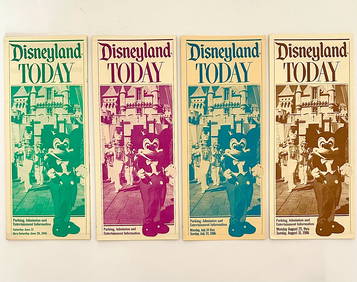
Lot of 4 EX Rare 1986 DISNEYLAND PARKS Foldout Brochures - READ ONSouth Florida Auction & Estate Sale Services Inc4.5(520)See Sold PriceMar 08, 2024
17th Century Hand Colored Engraved Map of GermanyGlobal Auctions Company4.3(36)See Sold PriceMar 03, 2024
De Jode, Rare, pub. 1593 - Map of Italy (Italiae Totius Orbis olim Domatricis Nova ExactissTrillium Antique Prints & Rare Books4.5(30)See Sold PriceFeb 24, 2024
1749-1771 HISTORY OF ROMAN EMPERORS 12 VOLUMES antique ILLUSTRATED w/ MAPSJasper524.5(9.8k)See Sold PriceFeb 27, 2024
1558 SCANDINAVIA SWEDEN ILLUSTRATED HISTORY Gothorum Sveonumque historia antiqueJasper524.5(9.8k)See Sold PriceFeb 27, 2024
1499 INCUNABULA FOLIO antique Sacred letters of St.Paul interpretation INCUNABLEJasper524.5(9.8k)See Sold PriceFeb 27, 2024
3 Vintage The World Lithographs, By JanssonThe Benefit Shop Foundation Inc.4.3(2.9k)See Sold PriceMar 13, 2024