Map L'AFRICA - Maps, MapsGuglielmo Sansone (1634-1703), copper engraving, handcoloured, illustration of the African continent, Paris, 1677, engraved by G. de Rossi, Rome, passepartout, glazed and framed, very good condition MSee Sold Price
1792 Elwe Map odf Africa -- L'Afrique Divisee en sesTitle/Content of Map: 1792 Elwe Map odf Africa -- L'Afrique Divisee en ses Empires, Royaumes, et Etats Date: 1792, Amsterdam Cartographer: J Elwe Size: 18 X 23.1 in. This is an outstanding, double-pagSee Sold Price
1792 Elwe Map of Africa -- L'Afrique Divisee en sesTitle/Content of Map: 1792 Elwe Map of Africa -- L'Afrique Divisee en ses Empires, Royaumes, et Etats Cartographer: J Elwe Year/Place: 1792, Amsterdam Size: 18 X 23.1 in. This is an outstanding, doublSee Sold Price
1792 Elwe Map of Africa -- L'Afrique Divisee en sesTitle/Content of Map: 1792 Elwe Map of Africa -- L'Afrique Divisee en ses Empires, Royaumes, et Etats Date: 1792, Amsterdam Cartographer: J Elwe Size: 18 X 23.1 in. This is an outstanding, double-pageSee Sold Price
Soldde la Tour: Antique Map of Africa, 1777Title/Content of Map: 'L'Afrique' Africa 'Zimbaoe'. The river Niger is shown without outlet into the sea Date Printed: 1777 Image Size: Approx 18.5 x 16.5cm, 7.25 x 6.25 inches (Medium); Please note tSee Sold Price
SoldL'Africa. Map by Sanson, revised by De Rossi.[De Rossi] L’Africa Nuovamente corretta, et accresciuta secondo le realtioni piu moderne. Double-page map of Africa by Guillaume Sanson, revised by Giovanni Giacomo de Rossi. Rome: De Rossi, 1687. FSee Sold Price
Sold1792 Elwe Map of Africa -- L'Afrique Divisee en sesTitle/Content: 1792 Elwe Map of Africa -- L'Afrique Divisee en ses Empires, Royaumes, et Etats Cartographer: J Elwe Year/Place: 1792, Amsterdam Size: 18 X 23.1 in. Description: This is an outstanding,See Sold Price
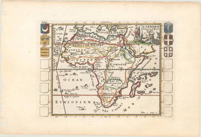
L'Africa. DE ROSSI / SANSON 1677 old antique vintage map plan chartTitle: L'Africa. DE ROSSI / SANSON 1677 old antique vintage map plan chart Description: L'Africa [Africa] by Published by Giovanni Giacomo de Rossi. G. Sansone, Giorgio Widman Sculp. (1677). Antique 1See Sold Price
1718 Chatelain Map of Africa -- Nouvelle Carte deTitle/Content of Map: 1718 Chatelain Map of Africa -- Nouvelle Carte de l'Afrique avec des Remarques et des Tables pour Trouver sans Peine les Differents Peuples de cette Partie du Monde… CartographSee Sold Price
1682 duVal Maps of Northern Africa -- Barbarie versTitle/Content of Map: 1682 duVal Maps of Northern Africa -- Barbarie vers L'Occident [on sheet with] Barbarie Vers L'Orient Cartographer: P duVal Year/Place: 1682 c., Paris Size: 4 X 4.8 in. This is aSee Sold Price
Santini / Janvier: Antique Map of Africa, 1784Title/Content of Map: 'L'Afrique divisée en ses principaux Etats assujettie aux Observations Astronomique par le Sr. Janvier Géographe. À Venise par Francois Santini rue St. Justine près la dite lSee Sold Price
Santini / Janvier: Antique Map of Africa, 1784TITLE/CONTENT OF MAP: 'L'Afrique divisée en ses principaux Etats assujettie aux Observations Astronomique par le Sr. Janvier Géographe. À Venise par Francois Santini rue St. Justine près la dite lSee Sold Price
1770 Bonne Map of Northwest Africa -- PartieTitle/Content of Map: 1770 Bonne Map of Northwest Africa -- Partie Occidentale De L'Ancien Continent, Depuis Lisbonne Jusqu'a La Riviere De Sierra Leona: Avec l'Isle Madere, les Isles Canaries, et celSee Sold Price
SoldAntique Map of AfricaCarte Des Costes de L'Afrique. Map by Mortier, Amsterdam, c. 1700. 24 1/2" x 20 1/2".See Sold Price
L'afrique Francoise Ou Du Senegal, French W. Africa MapL'afrique Francoise Ou Du Senegal'. French West Africa. 1727 Map by Guillaume de l'Isle. Approx 52.0 x 65.0cm, 20.5 x 25.5 inches (Large); Please note that this is a folding map. Large antique 18th ceSee Sold Price
SoldGiovanni Battista Ramusio Map of West Africa 1606Giovanni Battista Ramusio (1485-1557), "Parte De L'Africa," Venice, 1606. Woodcut map of part of West Africa. The delicate detail of the map includes illustrations of sea Monsters, ships, African peopSee Sold Price
Sold1792 Elwe Map of Southern Portion of Africa -- Carte deTitle/Content of Map: 1792 Elwe Map of Southern Portion of Africa -- Carte de l'Afrique Meridionale ou Pays entre la Ligne & le Cap de Bonne Esperance, et l'Isle de Madagascar Cartographer: J Elwe YeaSee Sold Price
1792 Elwe Map of Southern Portion of Africa -- Carte deTitle/Content of Map: 1792 Elwe Map of Southern Portion of Africa -- Carte de l'Afrique Meridionale ou Pays entre la Ligne & le Cap de Bonne Esperance, et l'Isle de Madagascar Date: 1792, Amsterdam CaSee Sold Price
1682 duVal Maps of Northern Africa -- Barbarie versTitle: 1682 duVal Maps of Northern Africa -- Barbarie vers L'Occident [on sheet with] Barbarie Vers L'Orient Cartographer: P duVal Year/Place: 1682 c., Paris Dimensions: 4 X 4.8 in. Descriptions: ThisSee Sold Price
SoldEarly Map Egypt Nubia AfricaDe l'Egipte. Antique map by Clouet, Paris, 1730. Egypt, Nubia, Abyssinia, Middle East, Asia. . 16" x 24.See Sold Price
de la Tour: Antique Map of Southern Africa, 1771Title/Content of Map: 'Partie de l'Afrique audelà de l'Equateur, Comprenant le Congo, la Cafrerie &c. Par Mr. Brion Ingr. Géoge. du Roy. A Paris, Chez le Sr. Desnos Ingén. Géogre. pour les GlobesSee Sold Price
de la Tour: Antique Map of Northern Africa, 1771Title/Content of Map: 'Partie de L'Afrique en deça de I'Equateur, Comprenant L'Egypte, la Barbarie, La Nigritie &c. Par Mr. Brion Ingr. Géogr. du Roi. A Paris chez Desnos Ingr. Géog. pour les GlobeSee Sold Price
SoldFOUR EUROPEAN HAND COLORED ENGRAVED MAPS18th through 20th Century. Comprising, the English Counties of Devonshire and Dorsetshire, a large map of Africa and a Dutch "De L' Academi des Royale Scieneces L' Amerique'. Largest (Africa) site meaSee Sold Price
1792 Elwe Map of Southern Portion of Africa -- Carte deTitle: 1792 Elwe Map of Southern Portion of Africa -- Carte de l'Afrique Meridionale ou Pays entre la Ligne & le Cap de Bonne Esperance, et l'Isle de Madagascar Date: 1792, Amsterdam Cartographer: J ESee Sold Price
WEST AFRICA Niger/Gambia rivers tribes towns. 'Pays des Negres'. MALLET 1683 mapJasper524.5(9.9k)See Sold PriceFeb 28, 2024
NORTH & WEST AFRICA. Sahara Niger river 'Zaara ou le Desert'. MALLET 1683 mapJasper524.5(9.9k)See Sold PriceFeb 28, 2024
Carte du Canal de Mosambique…. Madagascar Bonne Esperance. BONNE 1780 mapJasper524.5(9.9k)See Sold PriceFeb 28, 2024
Le Canal de Mosambique, l'Isle de Madagascar… Mozambique. Africa. BONNE 1788 mapJasper524.5(9.9k)See Sold PriceFeb 28, 2024
WEST AFRICA. Guinea. Nigeria Ghana Benin Togo Sierra Leone. MALLET 1683 mapJasper524.5(9.9k)See Sold PriceFeb 28, 2024
WEST CENTRAL AFRICA. Congo Angola Gabon Cameroon Sao Tome. MALLET 1683 old mapJasper524.5(9.9k)See Sold PriceFeb 28, 2024
NORTH AFRICA. 'Biledulgerid', a former North African country. MALLET 1683 mapJasper524.5(9.9k)See Sold PriceFeb 28, 2024
WEST AFRICA/MAGHREB Tribes Garamantes Getgulie 'Ancienne Libye'. MALLET 1683 mapJasper524.5(9.9k)See Sold PriceFeb 28, 2024
Le Canal de Mosambique, l'Isle de Madagascar… Mozambique. Africa. BONNE 1790 mapJasper524.5(9.9k)See Sold PriceFeb 28, 2024
Partie Occidentale de l’Afrique. West Africa coast Canary islands BONNE 1788 mapJasper524.5(9.9k)See Sold PriceFeb 28, 2024
NORTH AFRICA. Barbary. Morocco Tunisia Libya Egypt. 'Barbarie'. MALLET 1683 mapJasper524.5(9.9k)See Sold PriceFeb 28, 2024
NORTH AFRICA. Morocco Tunisia Libya. 'Mauritanie'. Malta Melita. MALLET 1683 mapJasper524.5(9.9k)See Sold PriceFeb 28, 2024
Carte de L'Algérie et de la Régence de Tunis' ANDRIVEAU-GOUJON Algeria 1850 mapJasper524.5(9.9k)See Sold PriceFeb 28, 2024
ANCIENT NORTH AFRICA. Greek colonies. "La Libye, L'Egypte…". TARDIEU 1830 mapJasper524.5(9.9k)See Sold PriceFeb 28, 2024
NUBIA. 'Nubie'. Nile Valley. Sudan Ethiopia Egypt. MALLET 1683 old antique mapJasper524.5(9.9k)See Sold PriceFeb 28, 2024
SUB-SAHARAN AFRICA. 'Ancienne Ethiopie'. Ancient Ethiopia. MALLET 1683 old mapJasper524.5(9.9k)See Sold PriceFeb 28, 2024
COLONIAL GABON & CONGO. Afrique équatoriale française. Brazzaville plan 1938 mapJasper524.5(9.9k)See Sold PriceFeb 28, 2024
SOUTHERN AFRICA Monomotapa (Mutapa Kingdom) Cafrerie (Kaffraria) MALLET 1683 mapJasper524.5(9.9k)See Sold PriceFeb 28, 2024
Partie Occidentale de l'Ancien Continent… W Africa Macaronesia. BONNE 1780 mapJasper524.5(9.9k)See Sold PriceFeb 28, 2024
L'Afrique Françoise ou du Senegal'. French West Africa. DE L’ISLE 1727 mapJasper524.5(9.9k)See Sold PriceFeb 28, 2024