Sold(1787) Map of North America from Best AuthoritiesHistoric Maps "Map of North America Drawn from the Latest and Best Authorities" Engraved for Jonathan Harrison by G. Terry (1787) Federal Period, Handcolored "Map of North America Drawn from the LatesSee Sold Price
Map of North America from the Best Authorities, 1800Map: North America from the Best AuthoritiesOrigin: London Date: 1800 Medium: Copper-engraved Size: 8 x 10 inches Little map of North America, with the River of the West, also called the Oregon, havinSee Sold Price
SoldGeneral Map of North America from the Best AuthoritiesCirca 1796 Antique Map, Title: "A General Map of North America from the best Authorities". Citation: Amos Doolittle, Sculp. Approximate size: 9-3/4" x 8-3/8". Please note that this lot has a confidentSee Sold Price
SoldGeneral Map of North America from the Best AuthoritiesTitle/Content of Map: General Map of North America from the Best Authorities Date Printed: 1797 Cartographer: DOOLITTLE, AMOS Size: 7.3X8.75 "Doolittle Sculp." From Morse's American Geography. Quite bSee Sold Price
SoldGeneral Map of North America from the Best AuthoritiesTitle/Content of Map: General Map of North America from the Best Authorities Date Printed: 1796 Cartographer: MORSE, JEDIDIAH Size: 7.3X8.75 "Engraved for third edition of Morse's Universal Geography:See Sold Price
North America from the Best Authorities, 1892Title/Content of Map: North America from the Best Authorities Date Printed: 1800 Material/Medium: paper Size: approx.8x10 inches 800, copper-engraved. Map of North America, with the River of the West,See Sold Price
SoldNorth America From the Best AuthoritiesCopper-engraved map. 19.5x23.5 cm. (7¾x9¼"). Much of the west is still speculative, with the possibility of a Northwest Passage via Slave Lake in Canada. Author: Anon. Heading: (North America) PlaceSee Sold Price
SoldGuthrie, William 1798 Map. Canada North America"British Colonies in North America from the best Authorities" Copper Engraved Map Published 1798, London for "A New Geographical, Historical and Commercial Grammar..." by William Guthrie. The maps areSee Sold Price
SoldGuthrie, William 1798 Map. General Map of North America"A General Map of North America from the best Authorities" Copper Engraved Map Published 1798, London for "A New Geographical, Historical and Commercial Grammar..." by William Guthrie. The maps are bySee Sold Price
SoldANTIQUE NORTH AMERICA MAP C. 1780, WILLIAM GUTHRIEFramed antique map, c. 1780, "A General Map of North America from the best Authorities", believed to be from "A New Geographical, Historical, and Commercial Grammar and Present State of the Several KiSee Sold Price
SoldASSORTED 18TH CENTURY MAPS, LOT OF FIVEASSORTED 18TH CENTURY MAPS, LOT OF FIVE, engravings on paper, including Jedidiah Morse "A General Map of North America from the best Authorities", England/Wales, Germany and Belgium. Not framed. 1745-See Sold Price
A Map of the Northern and Middle States; ComprehendingTitle/Content of Map: A Map of the Northern and Middle States; Comprehending the Western Territory and The British Dominions in North America. from The Best Authorities. Cartographer: G. ALLEN/MORSE'SSee Sold Price
c. 1763, A NEW MAP OF NORTH AMERICA(c. 1763), A NEW MAP OF NORTH AMERICA FROM THE BEST AUTHORITIES, by John Lodge, Choice Extremely Fine. 13.75" x 15.25," hand-colored in outline. From a periodical with the resulting typical folds. ExpSee Sold Price
Sold1792 NORTHEASTERN UNITED STATES HAND-COLORED MAP,1792 NORTHEASTERN UNITED STATES HAND-COLORED MAP, "A Map of the Northern and Middle States; Comprehending the Western Territory and the British Dominions in North America from the best Authorities", SSee Sold Price
SoldLate 18th - Early 19th Century British Map of NortLate 18th - Early 19th Century British Map of North America, A General Map of North America from the best Authorities, likely from an atlas, as upper left corner marked Page 777; trimmed to 8 x 9.25See Sold Price
SoldAFTER BAKER ISLINGTON ENGRAVER HAND COLORED MAPAFTER BAKER ISLINGTON, ENGRAVER, HAND COLORED MAP, H 8", W 9 1/4", "NORTH AMERICA FROM THE BEST AUTHORITIES":Framed. Date map was printed is unknown.See Sold Price
SoldMap of North America 300 years old (113585)This is a great color map, c.1700, titled "North America From the Best Authorities." See San Francisco Bay labelled as "Sir Francis Drake Harbor,"; the center of the West labelled "Quivira" (land of gSee Sold Price
SoldBaker map of North America c.1800Title: North America from the Best Authorities Author: Baker, Benjamin Description: Copper-engraved map. 19x3x23 cm. (7½x9").Little map of North America, with the River of the West, also called the OSee Sold Price
Four maps of North AmericaTitle: Four maps of North America Author: ** Description: Includes: Anon. A General Map of North America from the best Authorities. Copper-engraved, hand-colored in outline. 18.5x23 cm. c.1800. * ArroSee Sold Price
SoldMap: William Guthrie, "North America From the BestMap: William Guthrie, "North America From the Best Authorities," c. 1803, copper engraving, presented in a linen mat, shrink wrapped, H.- 8 in., W.- 9 1/2 in.See Sold Price
Map of North America c.1795Title: A General Map of North America from the Best Authorities Author: Guthrie, William Description: Copper-engraved map, hand-colored (later). Engraved by Russell. 18x23 cm. (7x9").From Guthrie's GeSee Sold Price
Sold1793 AMOS DOLITTLE Engraved Map of North AmericaHistoric Maps Amos Doolittle Engraved Map Titled "A General Map of North America from the best Authorities" Boston 1793 c. 1793, Engraved Copper Plate Map Engraved by Amos Doolittle, sculp., titled, "See Sold Price
SoldMap: William Guthrie, "North America From the BestMap: William Guthrie, "North America From the Best Authorities," c. 1803, copper engraving, presented in a linen mat, shrink wrapped, H.- 8 in., W.- 9 1/2 in.See Sold Price
Four maps of North AmericaTitle: Four maps of North America Author: ** Description: Includes: Anon. A General Map of North America from the best Authorities. Copper-engraved, hand-colored in outline. 18.5x23 cm. c.1800. * ArroSee Sold Price
LARGE EARLY 18TH C. DUTCH CHART OF UPPER NORTH AMERICA, PIERRE MORTIER (1661-1711), FRAMEDThomaston Place Auction Galleries4.4(389)See Sold PriceFeb 24, 2024
BLACK PANTHER SEXY WILD CAT BRONZE SCULPTURE BY MILOHouse of Treasure4.4(51)See Sold PriceFeb 29, 2024
Handmade ''Walking Panther'' Bronze SculptureWeatherham Estate Treasures3.9(157)See Sold PriceMar 07, 2024
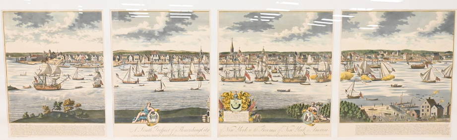
A South Prospect of Ye Flourishing City of New York in the Province of New York, North AmericaNadeau's Auction Gallery4.7(405)See Sold PriceFeb 24, 2024
1873 RELIGIOUS DENOMINATIONS OF THE WORLDNorth American Artifact Auctions4.6(184)See Sold PriceApr 20, 2024
1982 Billy Squire Emotions In Motion North America Tour Jersey ShirtMynt Auctions4.6(689)See Sold PriceFeb 27, 2024
Arrowsmith & Lewis - Map of North AmericaTrillium Antique Prints & Rare Books4.5(30)See Sold PriceFeb 24, 2024
Map: An 18thC engraved and hand coloured map of North America and South America, titled DeClaydon Auctioneers Ltd4.3(125)See Sold PriceFeb 26, 2024
New and Correct Map of North America With the West India Islands,Jasper524.5(9.8k)See Sold PriceFeb 27, 2024
Map of United States of North America, 1785Antiques Online Auctions4.6(410)See Sold PriceMar 14, 2024